Halema'uma'u
In December 2020, three volcanic vents opened at the bottom of Halema'uma'u crater and boiled away an entire lake. The water -- 167 feet deep, containing over 125 million gallons -- had only appeared the year before, the first recorded lake in the crater's history. Within hours, it was replaced by glowing lava. This is what Halema'uma'u does. The pit crater within Kilauea's summit caldera does not hold still. Its name means "house of the 'ama'u fern," but ferns are among the last things you will find here.
Two Centuries of Liquid Fire
British missionary William Ellis published the first English description of the crater in 1823, recording a vast lake of molten lava. That lake persisted for decades, shrinking gradually until it drained entirely after an earthquake swarm in December 1894. Mark Twain hiked to the caldera floor in 1866 and described the spectacle in vivid terms that would help define Kilauea in the Western imagination. After the lava disappeared, Halema'uma'u was left as a circular pit crater 360 meters wide -- quiet, steaming, but far from finished.
The Explosions of 1924
Beginning on the night of May 9, 1924, Halema'uma'u erupted explosively for two and a half weeks. Columns of ash and debris shot up to 9 kilometers high. Rocks weighing as much as 14 tons were ejected from the crater. In the community of Glenwood, 16 kilometers away, store gutters collapsed under the weight of muddy ash. On May 18, one person was killed by falling debris -- crushed while observing the eruption from what had seemed a safe distance. By the time the explosions ceased on May 27, the crater had nearly tripled in diameter to approximately 1,000 meters and deepened to about 285 meters. The quiet era was over, but the explosive era was just a prelude.
The Return of the Lava Lake
After 25 years of silence, Halema'uma'u woke again on March 19, 2008. At 2:58 in the morning, an explosion blew a hole 20 to 30 meters wide in the crater wall, scattering debris across a third of a square kilometer and damaging the Crater Overlook. It was the first explosive eruption since 1924, and within months, a lava lake became visible 130 feet below the lip of the newly formed Overlook Crater. For the next decade, the lake persisted -- rising, falling, occasionally spilling onto the crater floor. In May 2015, it overflowed for the first time, adding a 30-foot layer of fresh lava. Webcams broadcast the glow worldwide, and Halema'uma'u became one of the most-watched volcanic features on the planet.
Collapse and Rebirth
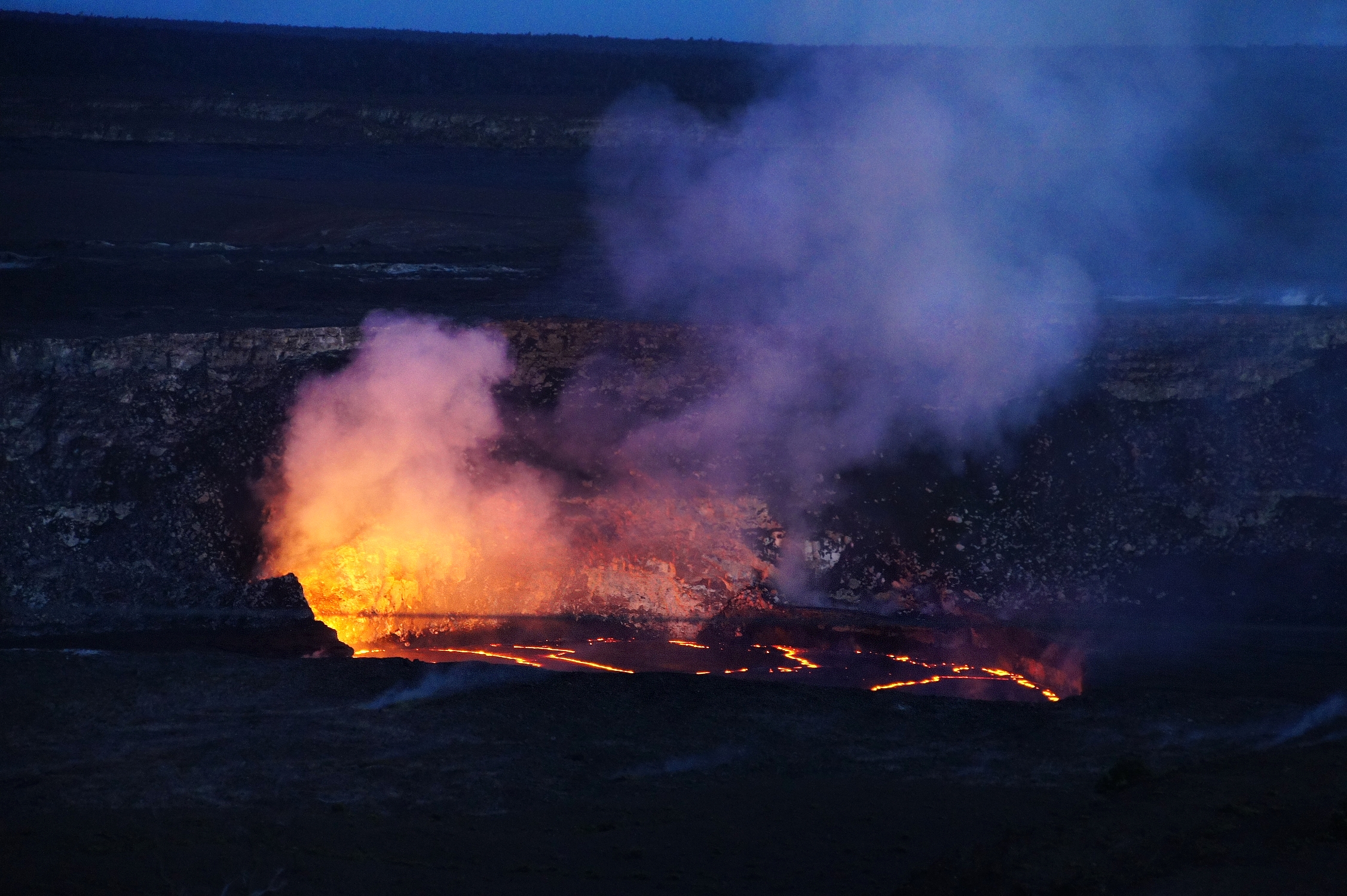
In May 2018, the lava lake drained as magma migrated to feed eruptions 40 kilometers away in lower Puna. The lake dropped 722 feet in less than a week before disappearing entirely. What followed was worse: explosive collapse events, ash clouds, earthquakes. The crater roughly doubled in size, its floor dropping 600 meters below the caldera rim. Then, in the summer of 2019, water appeared at the bottom -- warm, yellow with dissolved minerals, rising steadily. Scientists believe the 2018 collapse dropped the crater floor below the water table for the first time. The lake grew to six acres and 167 feet deep before the December 2020 eruption replaced it with lava. Eruptions have continued in pulses since then, and in December 2024, lava fountains exceeding 450 meters in height were recorded.
A Crater That Defies Prediction
Halema'uma'u has been a lava lake, an explosion crater, a quiet pit, a water lake, and a lava lake again -- all within recorded history. Hawaiian tradition holds that it is the home of Pele, and offerings are still placed at its rim. Scientists at the Hawaiian Volcano Observatory have watched it from progressively greater distances as the crater has grown more dangerous; the observatory's original buildings at the rim were damaged in 2018 and demolished in 2024. What makes Halema'uma'u compelling is not just its violence but its variability. No two decades here look the same. The crater reinvents itself with a persistence that makes permanence feel like a human invention.
From the Air
Halema'uma'u crater at 19.41°N, 155.286°W, within Kilauea Caldera. The crater is visible as a large circular depression within the broader caldera; active glow or steam plumes may be visible depending on current eruption status. Nearest airport is Hilo International (PHTO), approximately 30 miles northeast. Caution: volcanic emissions including SO2 gas and ash may affect visibility and air quality. Recommended viewing altitude 5,000-8,000 feet AGL.