Hanstholm Fortress
Four gun barrels, each weighing 110 tons, pointed north across the Skagerrak from the windswept coast of northwestern Denmark. Together with their sister battery at Kristiansand in Norway, they formed the jaws of a trap: a corridor of artillery fire designed to seal off an entire strait from the Allied navies. Only a ten-nautical-mile gap remained uncovered by their range. That gap was filled with mines. The Hanstholm Fortress was the Atlantic Wall's northern anchor, and the scale of what Nazi Germany built here remains difficult to grasp even when you are standing in the middle of it.
Hitler's Barrier Strategy
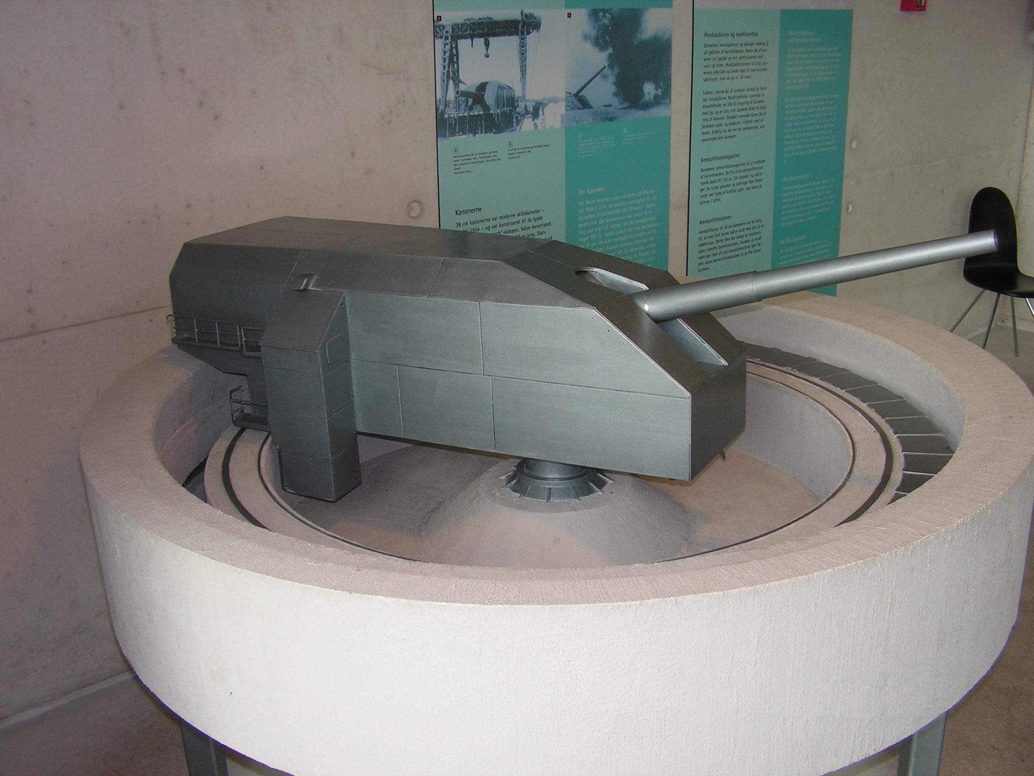
The decision to fortify Hanstholm came directly from Hitler in May 1940, barely a month after Denmark's occupation. The purpose was strategic and absolute: block the Skagerrak, and you block access to the Kattegat, the Baltic Sea, and the sea lanes supplying Eastern Norway. By May 1941, two of the planned guns were already in place. The fortress belonged to the sprawling Atlantic Wall, the chain of coastal fortifications stretching from Norway to the Spanish border, but Hanstholm was no ordinary battery. Its four 38 cm S.K.C/34 naval guns were among the most powerful coastal weapons deployed anywhere. Each gun position weighed 650 tonnes in total, shielded behind 3.5 meters of reinforced concrete. The fortress was defended by German Naval Artillery Battalion 118, supported by anti-aircraft batteries that bristled from the surrounding dunes.
Battleship Guns on Solid Ground
The 38 cm guns were never meant for a Danish clifftop. They were naval weapons, the same type mounted on the Bismarck-class battleships, originally intended for the battleship Gneisenau. When Gneisenau took damage in a bomb raid, the decision was made to put the guns where they could not be sunk: in concrete. Each could fire a 495 kg projectile to a range of 55 kilometers, or hurl an 800 kg shell 42 kilometers. The rate of fire was one round every ninety seconds, a rhythm of destruction that would have turned the Skagerrak into a killing zone for any convoy attempting to pass. Medium-sized 17 cm guns supplemented the main battery, creating overlapping fields of fire across the strait. From Hanstholm to Kristiansand, the water was covered. No Allied fleet ever attempted to force the passage.
After the Silence
The guns at Hanstholm never fired in anger at an invading fleet. The Allies bypassed the Skagerrak entirely, landing in Normandy instead. When the war ended, the fortress became an embarrassment of surplus firepower. Between 1951 and 1952, the massive 38 cm guns were scrapped, their barrels cut apart and their mountings dismantled. What could not be easily removed was the concrete: the bunkers, the gun pits, the command posts, the magazines. These structures were simply too massive and too deeply embedded in the landscape to demolish economically. They remained where they were, slowly being reclaimed by dune grass and coastal winds.
Fortress in a National Park
Today the remains of Hanstholm Fortress sit within Thy National Park, Denmark's first national park, creating a strange juxtaposition of preserved wilderness and preserved war machinery. The museum that now occupies the site preserves one uninstalled 38 cm gun barrel, the circular remains of the gun pits, models of how the original installations looked, German anti-aircraft guns, and even an anchor mine from the minefields that completed the Skagerrak barrier. Walking the fortress grounds, you move between bunkers half-buried in sand and wildflower meadows, between rusting steel and nesting seabirds. The contrast is the point. Hanstholm is a place where the ambitions of total war met the indifference of the Danish coast, and the coast is winning.
From the Air
Located at 57.12N, 8.62E on the northwestern tip of Jutland, Denmark. The fortress grounds are visible as cleared areas and bunker structures along the coastal cliffs within Thy National Park. Nearest airport is Thisted Airport (EKTS), approximately 15 km to the southeast. Best viewed at 3,000-5,000 feet to see the scale of the fortification complex along the coastline. On a clear day, the Skagerrak strait stretches northward toward Norway, with the sister fortress at Kristiansand (Movik) approximately 120 km across the water.