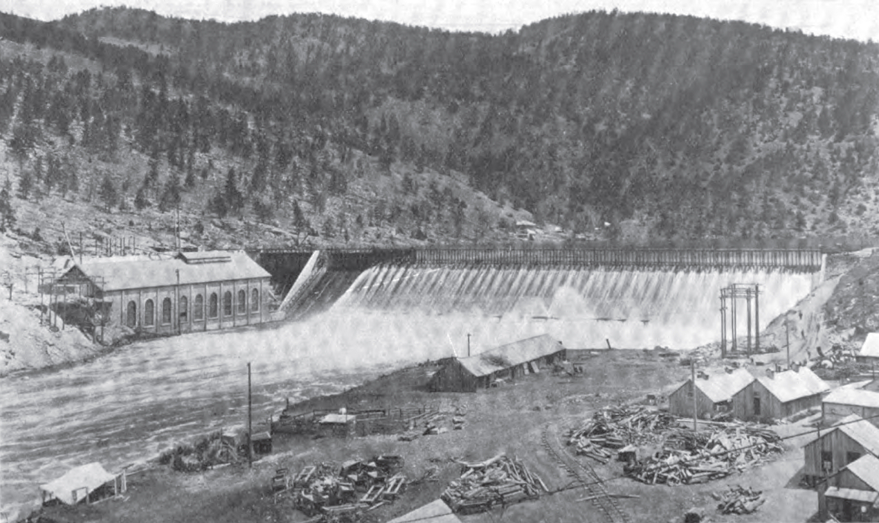
Hauser Dam
At 2:30 in the afternoon on April 14, 1908, silt-heavy water began gushing from the base of Hauser Dam. Six minutes later, a section of the structure tore loose, sending a wall of water roaring down the Missouri River toward the small town of Craig. The dam that Samuel Thomas Hauser had built to resurrect his fortune after the Panic of 1893 had just destroyed itself. But the story of Hauser Dam is not one of failure. It is a story of a man in his sixties who refused to give up, of engineering lessons learned the hard way, and of a second dam that still generates power today.
A Governor's Gamble
Samuel Thomas Hauser was not a man easily defeated. As Territorial Governor of Montana from 1885 to 1887, he had built an empire spanning banking, mining, railroads, ranching, and smelting. Then the Panic of 1893 swept through the American economy, and Hauser watched his fortune crumble. Rather than retire into obscurity, the sixty-something entrepreneur spotted opportunity in a new industry: hydroelectric power. He founded the Missouri River Power Company, which merged with another firm in February 1906 to create the United Missouri River Power Company. The dam bearing his name was declared operational on February 12, 1907, just thirteen months later. It cost $1.5 million, an enormous sum for its time.
Six Minutes to Disaster
The first Hauser Dam was a steel structure built on masonry footings atop gravel, with its ends anchored into bedrock on both sides of the river. Engineers James McKittrick and Gerry had argued repeatedly over the design, and Gerry ordered strengthening modifications. It was not enough. On that April afternoon, water pressure undermined the masonry footings, though the steel dam itself remained structurally sound. When the breach opened, six minutes was all it took for a large section to tear away. The remaining portions, still anchored to bedrock, held back enough water to reduce the flood's destructiveness. By 7:00 p.m., floodwaters reached Craig, though the narrow canyons of the Missouri had dissipated much of their energy. Great Northern Railway tracks from Craig to Ulm disappeared under water.
Rising from the River
Three months after the collapse, United Missouri River Power began reconstruction. Jesse Baker Snow, a noted engineer from New York, oversaw the new design. The second Hauser Dam opened in spring 1911, incorporating hard-won lessons from the failure. This rebuilt structure remains in operation today, a run-of-the-river dam that generates 17 megawatts through six turbines. Its reservoir, Hauser Lake, stretches behind the dam with a surface that supports rainbow and brown trout, walleye, and perch. The lake has become one of Montana's most popular weekend fishing destinations, regularly stocked with fish by state wildlife managers.
The Price of Power
The collapse nearly bankrupted Samuel Hauser. Cost overruns on the downstream Holter Dam project, waning investor confidence, and liability from the flood pushed him to the brink. He sold his stake to John D. Ryan, who merged the company with several others in October 1912 to form the Montana Power Company. Ownership has changed hands several times since, with NorthWestern Energy completing an $890 million purchase of eleven Montana hydroelectric facilities, including Hauser Dam, in November 2014. The dam that Hauser built to save his fortune ultimately outlived him and the company he founded, continuing to harness the Missouri River for Montana's electrical grid.
A Lake Born from Catastrophe
Hauser Dam's impounded waters did more than generate electricity. The reservoir inundated the lower portion of Prickly Pear Creek, creating nearby Lake Helena as an unintended consequence. This chain of water bodies northeast of the state capital now provides recreation, fisheries, and a visual reminder of how human engineering reshapes landscapes. From the air, the narrow reservoir appears as a blue ribbon threading through Montana's hills, its waters calm where the Missouri once rushed free.
From the Air
Hauser Dam sits at 46.765N, 111.887W on the Missouri River, approximately 15 miles northeast of Helena, Montana. The dam and Hauser Lake are clearly visible from altitude, with the narrow reservoir extending upstream. Helena Regional Airport (KHLN) lies about 12 nautical miles southwest. Best viewed at 3,000-5,000 feet AGL for perspective on how the dam fits into the Missouri's canyon system. The upstream Holter Dam and downstream Canyon Ferry Dam are visible on clear days, creating a chain of reservoirs.