Hawaiian-Emperor Seamount Chain
Trace a line on a map from the Aleutian Trench off Kamchatka to the youngest volcano growing beneath the sea southeast of the Big Island, and you have sketched the path the Pacific Plate has followed for 81 million years. The Hawaiian-Emperor seamount chain is that line made physical: more than 80 volcanoes strung across 6,200 kilometers of ocean floor, from ancient drowned mountains named after Japanese emperors to the still-erupting peaks that break the surface as the Hawaiian Islands. Somewhere around the middle of this chain, the line bends sharply, a kink that geologists have debated for decades, arguing over whether the Pacific Plate changed direction, the hotspot drifted, or both happened at once.
A Conveyor Belt of Fire
In 1963, Canadian geologist John Tuzo Wilson proposed an elegant explanation for the Hawaiian island chain. A fixed hotspot of volcanic activity, rooted deep in the Earth's mantle, punches through the Pacific Plate as the plate drifts northwest. Each volcano rides the plate away from the hotspot like luggage on a conveyor belt, growing active as it passes over the magma source, then going dormant as it moves beyond reach. The islands and seamounts form a timeline written in basalt: the Big Island of Hawaii, with four active volcanoes, sits directly over the hotspot today. Kure Atoll, 2,300 kilometers to the northwest, is a barely-there ring of coral around a volcano that last erupted roughly 30 million years ago. Still farther north, the Emperor Seamounts have sunk entirely below the surface, their ages reaching back 85 million years to a time when dinosaurs still walked the continents.
The Bend That Won't Be Explained
About halfway along the chain, the Emperor Seamounts and the Hawaiian ridge meet at an angle of roughly 120 degrees, a conspicuous bend that has appeared in geology textbooks for decades as evidence that the Pacific Plate abruptly changed direction about 47 million years ago. The explanation was tidy and satisfying until researchers began testing it. Paleomagnetic data from ancient lava flows on the Emperor Seamounts showed that the hotspot itself may have drifted southward over time, complicating the picture. Tarduno and colleagues proposed that circulation patterns in the solid but slowly flowing mantle, a kind of mantle wind, could have carried the plume, making the bend a record of hotspot movement rather than plate motion. Other researchers, including Niu, suggested a "trench jam" caused by buoyant seamounts arriving at a northern subduction zone and resisting descent into the mantle, forcing the plate to pivot. The current best-supported model combines both effects: a genuine change in plate direction plus modest north-south drift of the hotspot itself.
From Shield Volcano to Seafloor Ghost
Every volcano in the chain follows the same lifecycle, though at different speeds and stages. Over the hotspot, a seamount grows through a submarine pre-shield stage, piling up lava until it breaks the ocean surface. Active eruptions build a massive shield volcano. As the plate carries the volcano away from the magma source, eruptions weaken and eventually cease. Erosion carves the peak while the seafloor slowly subsides beneath its weight. The volcano shrinks from island to atoll island, from atoll to reef, and finally to a flat-topped seamount called a guyot, a drowned mesa resting hundreds or thousands of meters beneath the waves. The Kamaehauakanaloa Seamount, formerly known as Loihi, is the youngest member of the chain, still growing 35 kilometers southeast of the Big Island in the submarine pre-shield stage. If the pattern holds, it will break the surface in tens of thousands of years and become the next Hawaiian island.
Emperors Beneath the Waves
The oldest confirmed seamount in the chain, Detroit Seamount, dates to 81 million years ago. Meiji Seamount, still farther north, is likely older. Many of the Emperor Seamounts are named after Japanese emperors, a convention that gives the northern half of the chain a roster of imperial names attached to submerged volcanic ruins. These ancient peaks have long since subsided below the reach of sunlight and coral. The chain terminates at the Kuril-Kamchatka Trench, a subduction zone where the Pacific Plate dives beneath the North American Plate and the seamounts are finally destroyed, swallowed back into the mantle that created them millions of years before. From the 1960s to the 1980s, the seamounts were heavily bottom-trawled by fishing vessels, particularly Japanese ships targeting armorhead fish. Trawling has continued at lower rates, regulated by the North Pacific Fisheries Commission.
A Monument in the Middle of the Ocean
In 2006, President George W. Bush designated the Papahanaumokuakea Marine National Monument, encompassing the northwestern Hawaiian Islands, as one of the largest protected areas in the world. The proclamation limited tourism and called for a phase-out of commercial fishing by 2011, recognizing that the chain's ecological value extends far beyond its volcanic geology. The atolls and shallow banks of the northwestern islands harbor monk seals, green sea turtles, and millions of nesting seabirds in an environment largely free of human habitation. Beneath the surface, the seamounts create oases of marine biodiversity, their slopes concentrating nutrients and currents in ways that attract life to what would otherwise be the open-ocean equivalent of a desert. The chain is simultaneously a geological record, a marine sanctuary, and a reminder that the Earth's interior has been reshaping the surface of the Pacific for longer than most mountain ranges on land have existed.
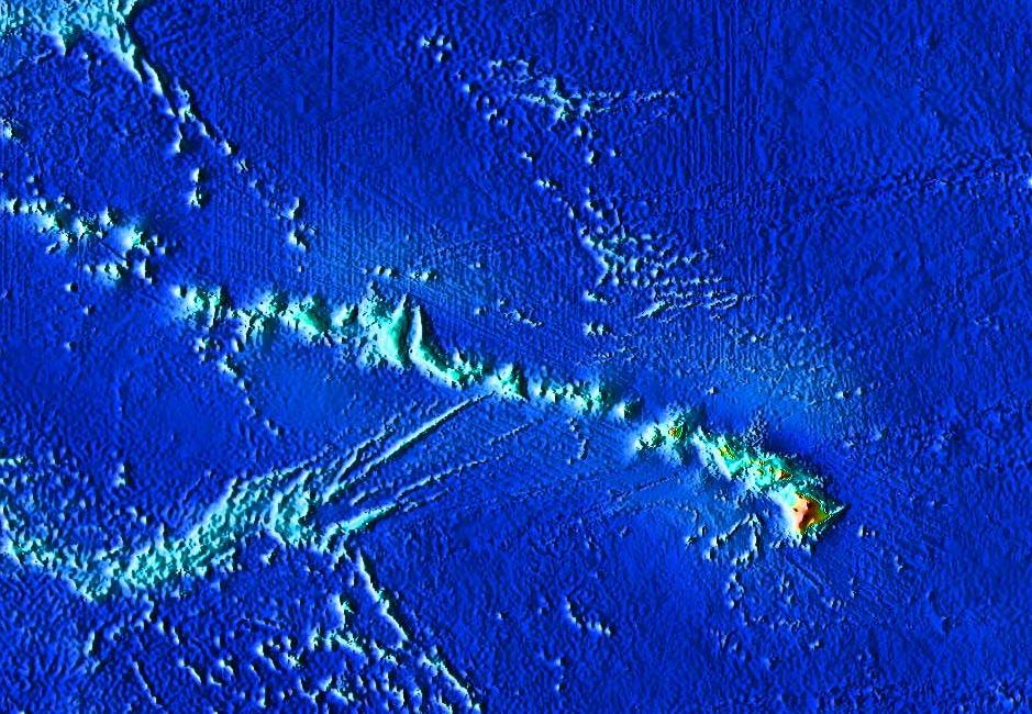
From the Air
The Hawaiian-Emperor seamount chain stretches approximately 6,200 km across the North Pacific, from near the Kamchatka Peninsula (roughly 55N, 168E) to the Big Island of Hawaii (19.82N, 155.47W). The Hawaiian Islands portion is the only segment visible above water. From cruising altitude over the central Pacific, the northwestern Hawaiian Islands appear as scattered atolls and low reef islands. Nearest major airports to the Big Island end: Ellison Onizuka Kona International (PHKO) and Hilo International (PHTO). The Emperor Seamounts are entirely submerged and not visible, but the chain's path can be traced on bathymetric maps as a clear ridge line across the ocean floor.