Hell Gate
The name is a mistranslation that stuck. When Dutch explorer Adriaen Block navigated this churning stretch of the East River sometime between 1614 and 1616, aboard the Onrust during his circumnavigation of Long Island, he called it Hellegat, borrowing the name from a waterway at the mouth of the Scheldt in his native Zeeland. In Dutch, it meant "bright gate." But where tides from Long Island Sound, the Harlem River, and New York Harbor collide against submerged rocks, there was nothing bright about the passage. English speakers heard "Hell Gate" and decided the translation fit better than the original.
A Graveyard for Ships
For more than two centuries, Hell Gate earned its anglicized name. The strait sits where Astoria, Queens, faces Randall's and Wards Islands, and the convergence of tidal currents from multiple directions created whirlpools and surges that could spin a ship sideways and drive it onto submerged reefs. Rocks with names like Pot Rock, Flood Rock, and Hallet's Point lurked just beneath the surface, their positions shifting unpredictably with the tides.
In the 1850s, roughly two percent of all ships attempting the passage ran aground. Merchants petitioned the New York State legislature repeatedly for relief. In 1832, the legislature was presented with a proposal to dig a canal through Hallet's Point to bypass Hell Gate entirely. Their solution was more modest and arguably more reckless: they hired pilots trained to navigate the shoals and considered the problem managed for the next fifteen years. Meanwhile, ships continued to founder, and fortunes continued to sink.
The French Engineer and the Leviathan Problem
In 1849, Benjamin Maillefert, a French engineer specializing in underwater blasting, began clearing the worst rocks. Ebenezer Meriam organized a public subscription to pay him six thousand dollars to reduce Pot Rock to a depth of 24 feet at low water. Maillefert made progress, but the channel remained treacherous.
The urgency grew as ships grew. Isambard Kingdom Brunel's SS Great Eastern, popularly known as the Leviathan, represented a new generation of vessels whose deep drafts demanded more water beneath their keels than the harbor's main channels through the Narrows could reliably provide. Sand from littoral drift was silting up those approaches, reducing their depth year by year. New York faced a stark commercial reality: if the harbor's back door through Hell Gate could not be widened and deepened, the city risked losing its status as America's premier port to rivals with deeper water.
The Biggest Blast on Earth
Congress appropriated twenty thousand dollars for the Army Corps of Engineers to continue where Maillefert had left off, but the money vanished without appreciable results. The Civil War intervened, and it was not until the late 1860s that the Corps received a proper mandate. Colonel James Newton estimated the project would cost one million dollars, set against annual shipping losses of two million. The math was clear.
Newton began undermining the reefs from below, tunneling into the rock and packing the cavities with explosives. Hallet's Point was blasted in 1876. Then he turned to Flood Rock, a nine-acre reef that was the channel's worst hazard. After years of tunneling, on October 10, 1885, Newton's daughter set off the charge. The detonation sent a geyser of water and rock into the sky, watched by spectators that included Civil War general Philip Sheridan and abolitionist Henry Ward Beecher. It was reported as the largest peacetime, man-made explosion until the advent of the atomic bomb. The East River shuddered, and Hell Gate began to lose its fearsome reputation.
Bridges Over Tamed Water
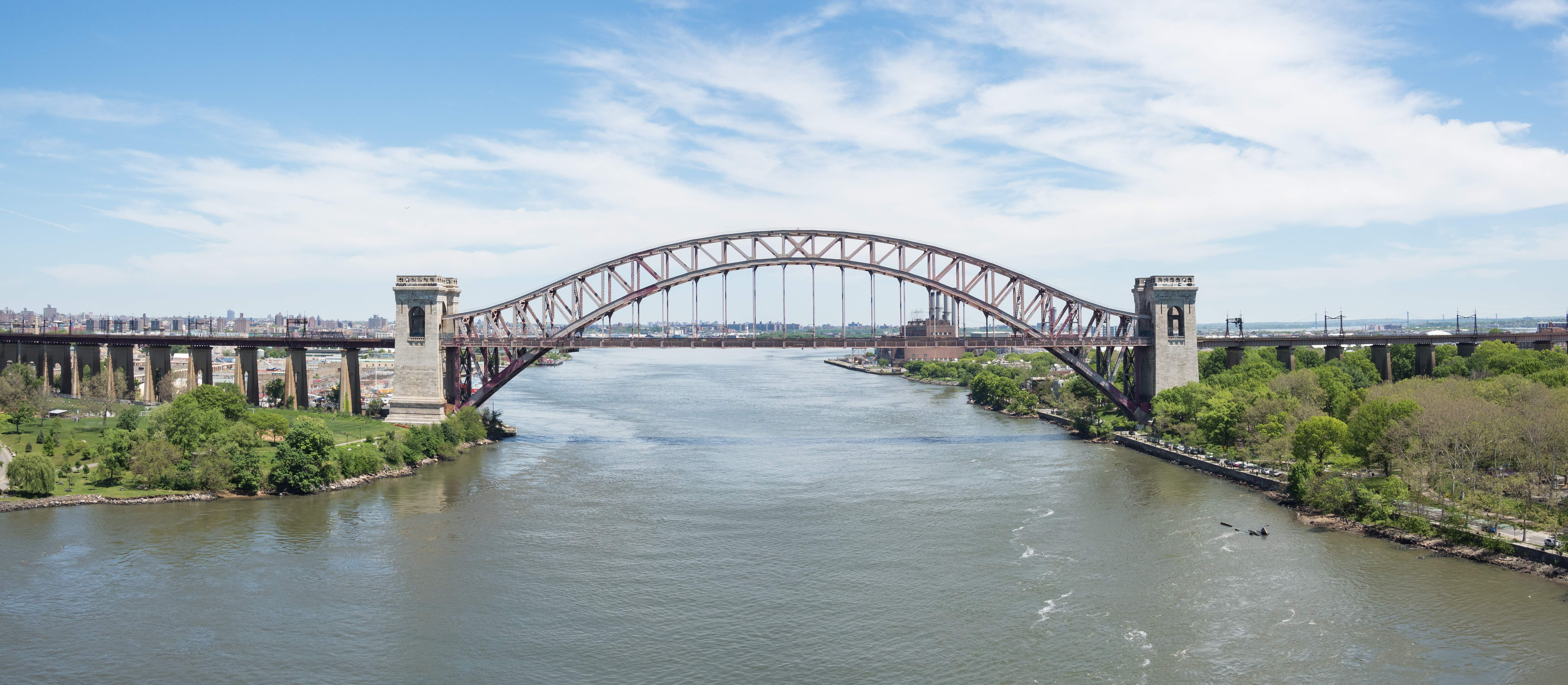
With the rocks cleared, Hell Gate became a strategic corridor rather than a navigational nightmare. In 1917, the New York Connecting Railroad Bridge, now called the Hell Gate Bridge, arced over the strait, connecting Wards Island to Queens and providing a direct rail link between New England and New York City. Its distinctive steel arch, painted a deep red since it first opened and bearing the unofficial name Hell Gate Red, was designed by Gustav Lindenthal and became one of the city's most recognizable silhouettes.
In 1936, the Triborough Bridge, now the Robert F. Kennedy Bridge, added vehicular connections among Manhattan, the Bronx, and Queens, with Hell Gate churning beneath. The strait that once destroyed ships now carries Amtrak trains between Boston and Washington. Kayakers and sailors still treat it with respect, timing their passages to the tidal windows. But the whirlpools that terrified Adriaen Block and swallowed merchant vessels for two hundred years have been tamed by dynamite and engineering, leaving behind a name that remembers what the water once was.
From the Air
Hell Gate is located at approximately 40.781N, 73.925W, in the East River between Astoria, Queens, and Randall's/Wards Islands. The Hell Gate Bridge (distinctive steel arch) and the Robert F. Kennedy Bridge (Triborough) are the primary visual landmarks. Best viewed from 1,500-3,000 feet altitude approaching from the south along the East River. The converging currents are sometimes visible as disturbances in the water surface. Nearby airports: KLGA (LaGuardia, very close to the north), KJFK (John F. Kennedy International), KEWR (Newark Liberty International).