Hernando Island
In 1962, Prince Wilhelm zu Wied of Koblenz on the Rhine paid $80,000 for an island. Not a tropical resort island or a Mediterranean retreat, but a 2,710-acre patch of pine and fir in British Columbia's Salish Sea that had been logged, farmed, and mostly abandoned over the previous half-century. A decade later, the prince sold to a syndicate. By 1975, fifty shareholders had bought the ownership company, and Hernando Island had become something rare: a cooperatively owned community where each of 52 shares corresponds to a specific lot, and the island itself -- with its caretaker, dock, helipad, community garden, and tennis courts -- belongs to everyone who lives there.
Names From a Ship That Never Landed
The Tla'amin Nation, formerly called Sliammon, held Hernando as part of their traditional territory long before any European ship appeared on the horizon. Archaeological excavations have unearthed underground houses built for fortification -- defensive structures suggesting a history far more complex and contested than the island's current tranquility implies. In 1792, Spanish explorers Cayetano Valdes and Dionisio Alcala Galiano sailed through these waters and named the island after Hernan Cortes, the conqueror of Mexico. They named neighboring Cortes Island for the same man. The Spanish never settled here, never built so much as a dock, yet their names adhered to the landscape like barnacles -- persistent and immovable despite having no local roots.
The Shay That Crossed the Island
Non-native settlers arrived in the 1880s to farm and log, but most had moved on by the early 1900s. The exception was Michael Manson, a politician whose family accumulated extensive landholdings and managed the Campbell River Lumber Company's operations on the island. In 1912, the company acquired Locomotive No. 2, a Shay geared engine bought from the bankruptcy trustee of the Lenora Mt. Sicker Railway on Vancouver Island. The Shay presumably retained its original three-foot gauge -- narrow enough to twist through the forest on tight curves. This logging railway hauled timber across Hernando to the pier at Stag Bay, where logs were dumped into the ocean and towed to a mill. The locomotive operated until 1920, when it was wrecked and scrapped. After logging ceased, some Manson family members stayed on as farmers, but the island's industrial chapter was over.
Stag Bay and the Steamboat Era
In the 1890s, Stag Bay was Hernando's only good anchorage -- a sandy stretch along an otherwise rocky shore. A weekly steamboat service connected the island to the wider world starting in the early 1890s and lasted until about 1910. The government built a 665-foot wharf in 1895, a substantial structure for a small island. When that wharf deteriorated beyond repair, a floating 450-foot replacement went in at Stag Bay in 1903. For a brief window between 1893 and 1899, Hernando even had a post office and a school -- markers of a community that believed it was growing. The post office closed, the school shuttered, and the steamboats eventually stopped coming.
Island Time, Cooperatively
The cooperative structure that emerged in the 1970s gives Hernando its distinctive character today. Property ownership is represented by shares in the co-op rather than conventional land titles, and the community maintains shared infrastructure including a dock, helipad, community garden, and recreational courts. Reaching the island requires either a water taxi from Campbell River -- Way West Water Taxis and Discovery Launch operate scheduled summer services -- or a floatplane via CorilAir. There are no ferries, no bridges, no roads connecting Hernando to anywhere else. Due north lies Cortes Island and the Twin Islands. Southwest is Mitlenatch Island, the seabird sanctuary. Southeast is Savary Island. Hernando sits among them all, 92 percent tree-covered, its 21 kilometers of coastline enclosing a community that chose isolation and made it work.
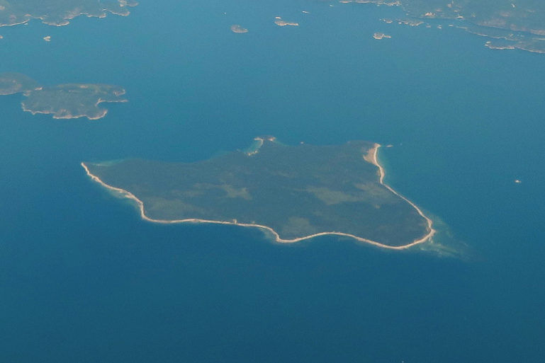
From the Air
Located at 49.98°N, 124.92°W in the Discovery Islands of BC's Salish Sea, between Campbell River and Powell River. Hernando is a distinct forested island visible at low altitude, with 92% tree cover of pine and fir. Maximum elevation is only 85 meters. Look for the dock and helipad near Stag Bay on the island's east side. Cortes Island lies due north, Mitlenatch Island to the southwest, Savary Island to the southeast. Campbell River Airport (CYBL) is the nearest major facility, approximately 20 nm to the east. Best viewed at 1,500-3,000 feet AGL. The island's 21 km coastline is predominantly rocky with sandy sections at Stag Bay.