Hida Mountains
In the 1870s, English geologist William Gowland trudged through the mountains of central Honshu and saw something that reminded him of home -- or rather, of Europe's most celebrated range. He called what he found the "Japanese Alps," and the name stuck. But Gowland was specific: he meant only the Hida Mountains, the northernmost and most dramatic of the three ranges that would eventually inherit the title. The Kiso Mountains (Central Alps) and Akaishi Mountains (Southern Alps) received the label later, almost as afterthoughts. The Hida range came first because it demanded the comparison most forcefully.
The Shape of a Y
Seen on a map, the Hida Mountains form a massive Y sprawling across four prefectures: Nagano, Toyama, Gifu, and a sliver of Niigata. The southern peaks compose the stem, running north until the range splits into two parallel arms separated by one of the steepest V-shaped valleys in Japan. The western arm, the Tateyama Peaks, is dominated by Mount Tsurugi and Mount Tate, whose sacred status has drawn pilgrims for centuries. The eastern arm, the Ushiro Tateyama Peaks, is anchored by Mount Shirouma and Mount Kashimayari. Between them, the Kurobe River has carved a gorge so deep and narrow that building the Kurobe Dam -- Japan's tallest at 186 meters -- required seven years of construction and claimed 171 lives.
Glaciers That Should Not Exist
For decades, scientists believed no glaciers survived in East Asia south of Kamchatka. The latitude was too low, the climate too temperate. Then researchers took a closer look at Mount Tsurugi and Mount Tate in the western Hida range and found three small glaciers clinging to existence on their high slopes. The explanation lies in geography: the Hokuriku region receives some of the heaviest snowfall on Earth, fed by moisture-laden winds sweeping off the Sea of Japan. That extraordinary precipitation, piling meters of snow on peaks that barely clear 3,000 meters, creates conditions just cold and wet enough for ice to persist year after year. These are not remnants of the last ice age -- they are active glaciers, grinding slowly forward, a quiet rebuke to the assumption that this part of the world had moved past such things.
A Roster of Giants
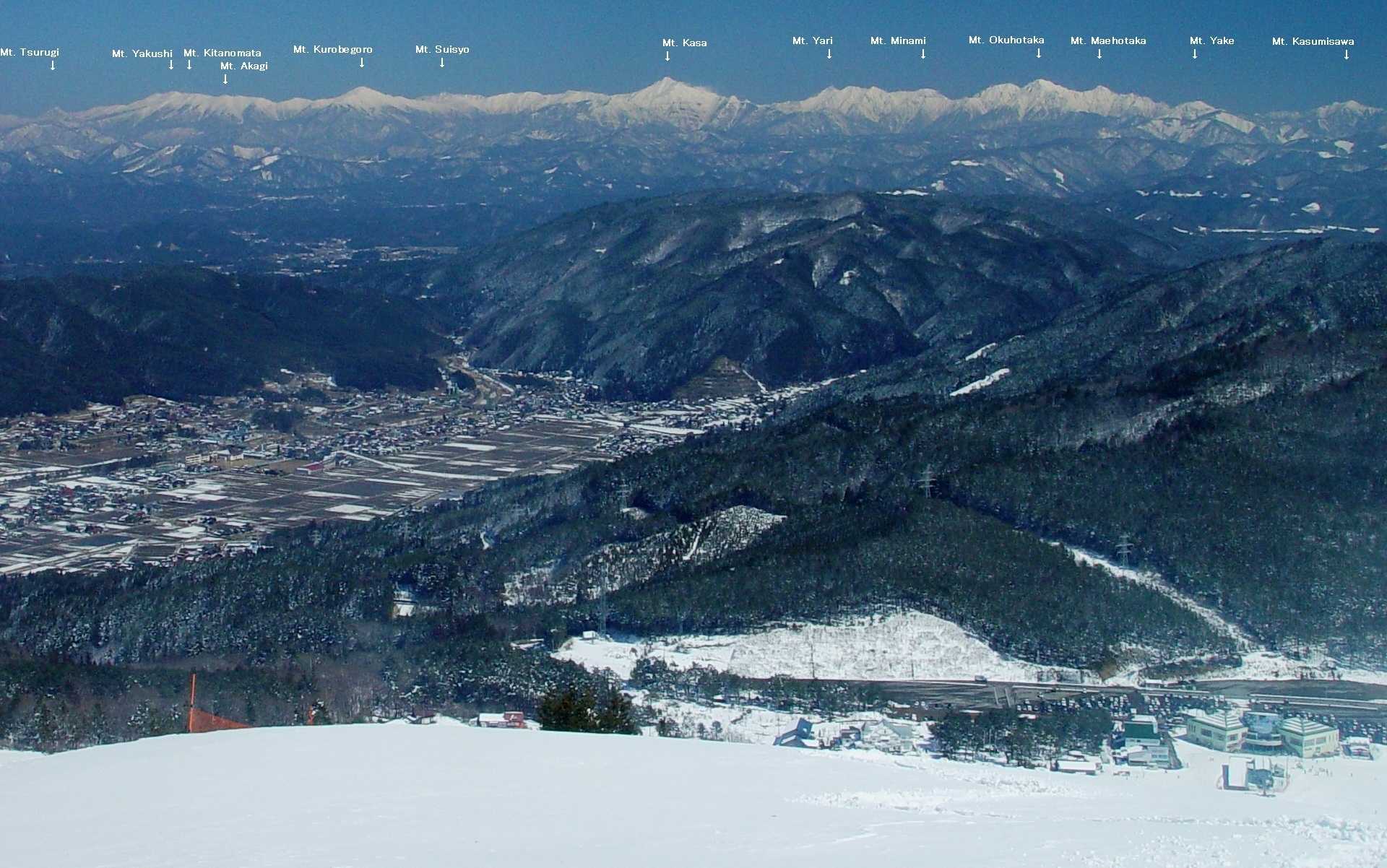
The Hida Mountains contain some of Japan's most celebrated summits. Mount Hotaka -- specifically Oku-Hotaka-dake at 3,190 meters -- stands as the range's highest point and the third-tallest peak in all of Japan, surpassed only by Mount Fuji and Mount Kita. Mount Yari, the spear-shaped pyramid at 3,180 meters, ranks fifth nationally and draws climbers from across the world to its exposed ridgeline traverses. Mount Tate, one of Japan's three sacred mountains, anchors the western arm. Mount Tsubakuro, Mount Noguchigoro, Mount Norikura -- each name carries weight in Japanese mountaineering circles. The range is threaded with multi-day hiking routes connecting these peaks, supported by a network of mountain huts that make the Hida Mountains surprisingly accessible despite their rugged terrain.
The Men Who Mapped the Alps
The Hida Mountains owe their international reputation to a succession of determined foreigners. Gowland, who coined the name Japanese Alps, was the first documented non-Japanese climber to summit Mount Yari in 1878. Walter Weston, the British missionary who arrived a decade later, took Gowland's phrase and broadcast it to the world through his 1896 book, Mountaineering and Exploration in the Japanese Alps. Weston's advocacy helped establish the Japanese Alpine Club in 1905 and was instrumental in the creation of Chubu-Sangaku National Park, which now protects much of the central Hida range. The park encompasses the Kamikochi valley, one of Japan's most pristine alpine environments, along with the high ridges and volcanic peaks that surround it. What Gowland named and Weston championed, Japan has preserved with characteristic thoroughness.
From the Air
The Hida Mountains (Northern Alps) stretch across central Honshu centered around 36.5N, 137.6E, spanning Nagano, Toyama, Gifu, and Niigata prefectures. The range forms a distinctive Y-shape visible from altitude, with peaks exceeding 3,000 meters including Oku-Hotaka (3,190 m) and Mount Yari (3,180 m). The Kamikochi valley is visible as a flat green corridor on the eastern side. The Kurobe Dam and its reservoir are prominent features in the central gorge. Nearest airports: Matsumoto Airport (RJAF) to the east, Toyama Airport (RJNT) to the northwest. Extremely rugged terrain with rapid weather changes -- maintain high altitude when crossing. Snow cover persists on upper slopes well into summer.