High Road to Taos
Every village along the High Road to Taos has a name that tells a story. Nambe means People of the Round Earth in Tewa. Truchas means trout, for the fish-filled river that sustained a frontier settlement built as a walled fortress against Apache and Comanche raids. Las Trampas translates to the traps. Chimayo is synonymous with healing earth and handwoven textiles passed down through generations of Spanish colonial families. This official New Mexico scenic byway winds through the Sangre de Cristo Mountains between Santa Fe and Taos, but calling it a road understates what it actually is: a living corridor through four centuries of human persistence in the high desert.
Where the Road Begins
The High Road starts north of Santa Fe in Pojoaque at the intersection of U.S. 285/84 and State Road 503. It quickly reaches Nambe Pueblo, founded in the 14th century, whose plaza is a registered National Historic Landmark. The original grand church on State Road 503 no longer stands -- a botched restoration attempt caused it to collapse. The pueblo encompasses land with waterfalls, lakes, and mountain terrain. Until about 1830, Nambe was known for a distinctive pottery style called Nambe Polychrome. Today, traditional pottery is making a comeback, with artisans working in black-on-black and red-on-white styles, while weaving is also reemerging. From Nambe, the road pushes through rolling badlands and wind-carved hoodoos before dipping into the green farming valley of Chimayo.
Pilgrims and Weavers of Chimayo
Chimayo draws visitors for two things: faith and fiber. The Santuario de Chimayo, a tiny adobe church built between 1811 and 1816, attracts pilgrims from across the United States and Mexico. On Good Friday, crowds swell into the thousands as walkers complete pilgrimages of dozens of miles to reach this small sanctuary in the valley. Nearby, the Rancho de Chimayo Restaurant occupies a historic adobe building, and the village is dotted with traditional weaving studios run by descendants of the original Spanish settlers. The handwoven textiles of Chimayo -- blankets, rugs, and garments in bold geometric patterns -- represent an unbroken craft tradition stretching back centuries. From Chimayo, State Road 76 begins its climb into the Sangre de Cristo Mountains.
Woodcarvers, Trout, and Fortress Walls
The mountain villages arrive in quick succession, each with its own character. Cordova is known for its woodcarvers, particularly those working in the Cordova Style pioneered by George Lopez: unpainted santos carved to reveal the natural grain and shape of the wood. Higher still, the village of Truchas perches on a mesa backed by snow-capped Truchas Peaks, a scattering of adobe houses that served as the set for the film adaptation of John Nichols's novel The Milagro Beanfield War. Truchas was established by royal land grant in 1754 specifically as a buffer against Apache and Comanche raiders. Its settlers built a walled compound around a central plaza and hand-dug miles of acequias to bring water from the river. Many residents still farm the land today, though others commute to jobs in Santa Fe or Los Alamos.
Land Grants and Mountain Churches
Beyond Truchas, the road enters the former Las Trampas Land Grant, now part of the Carson National Forest. Las Trampas itself was founded in 1751 by royal grant as Santo Tomas Apostol del Rio de las Trampas -- Saint Thomas, Apostle of the River of Traps. Despite smallpox epidemics and raids by Comanche and Apache, the settlers built the stately San Jose de Gracia Church, completed in 1776 and now a National Historic Landmark. Farther along, Picuris Pueblo occupies a strategic site at the confluence of two rivers and a major mountain pass leading to the Great Plains. Spanish explorer Juan de Onate called these people pikuria, meaning those who paint. Before Spanish contact, Picuris was one of the largest and most powerful pueblos in the region.
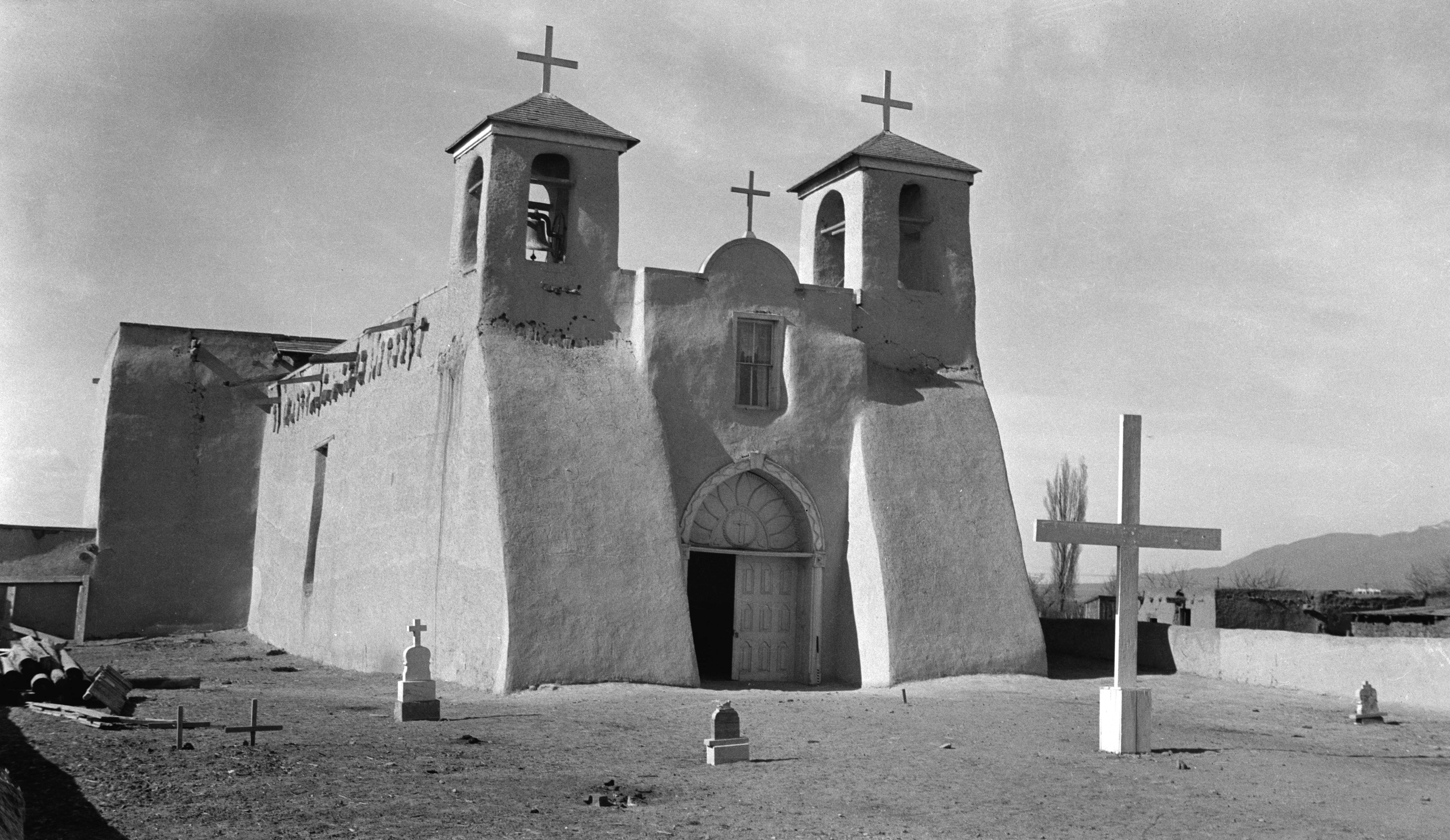
The Church at the End of the Road
The High Road officially ends where State Road 518 meets State Road 68 in Ranchos de Taos, but its symbolic terminus is a few blocks south at the San Francisco de Asis Mission Church. Constructed between 1772 and 1815, this adobe church is one of the most painted and photographed buildings in America. Georgia O'Keeffe rendered its massive rear buttresses in oils. Ansel Adams and Paul Strand captured them on film. The sculptural adobe forms seem to change shape and shadow with every shift in the New Mexico light. The journey from Santa Fe has taken travelers through Pueblo communities founded in the 14th century, Spanish colonial villages established by royal decree in the 18th century, and mountain forests that connect them all. The High Road is not merely scenic. It is a cross-section of northern New Mexico's layered past, visible in every church, plaza, and acequia along the way.
From the Air
The High Road to Taos runs roughly northeast from Santa Fe (KSAF) to Taos (KSKX), threading through the Sangre de Cristo Mountains at elevations ranging from approximately 6,000 to 8,500 feet. The byway begins near Pojoaque at approximately 35.89N, 106.02W. From the air, the route traces a winding path through mountain valleys and over high mesas, with the snow-capped Truchas Peaks (13,102 feet) prominent to the east. Key visual landmarks include the green valley of Chimayo, the mesa-top village of Truchas, and the distinctive adobe forms of the churches at Las Trampas and Ranchos de Taos. Watch for mountain weather and terrain-induced turbulence along the Sangre de Cristo range.