Hirakud Dam
Every summer, when the reservoir recedes, the temples come back. Stone walls and carved pillars emerge from the mud of Hirakud Reservoir like memories that refuse to stay buried -- remnants of Padmapur, one of the most populous towns in western Odisha before the dam swallowed it whole. Two inscribed stones, recovered from what is believed to be the Padmaseni temple, have rekindled interest in these submerged ruins. After nearly seven decades underwater, some structures remain intact, periodically vanishing beneath the waves only to resurface again. They are a reminder that Hirakud Dam, for all its engineering triumph, exacted a price that no cost estimate ever fully captured.
A Nation's First Ambition
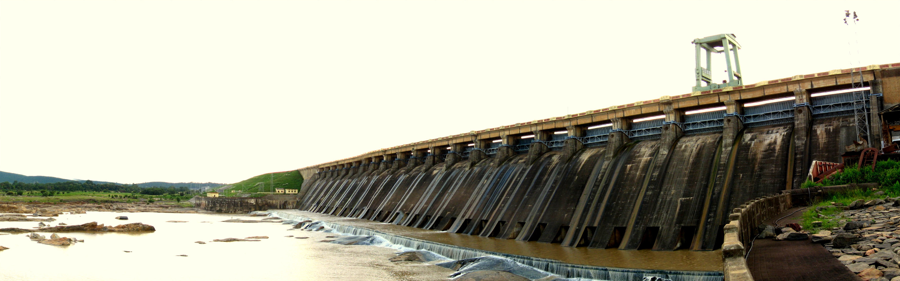
The foundation stone was laid on 15 March 1946, more than a year before Indian independence -- an act of faith in a future that had not yet arrived. Sir Hawthorne Lewis, the Governor of Odisha, presided over the ceremony, but it was Jawaharlal Nehru who would make Hirakud his own. On 12 April 1948, the new Prime Minister laid the first batch of concrete, inaugurating one of independent India's first major multipurpose river valley projects. The Mazumdar Committee, appointed in 1952, projected a cost of 92.80 crore rupees and completion by June 1955. The dam was finished in 1953, though Nehru did not formally inaugurate it until 13 January 1957. Power generation and irrigation began in 1956, reaching full capacity a decade later. What emerged was a colossus: 25.8 kilometers of dam and earthen dykes stretching across the Mahanadi, the main structure flanked by 21 kilometers of embankments closing low saddles between the hills. Behind it, a reservoir 55 kilometers long.
The River Tamed, the Delta Saved
To understand why India built Hirakud, you have to understand the Mahanadi. In the upper drainage basin, centered on the Chhattisgarh Plain, periodic droughts scorched crops. Downstream in the delta, the same river flooded catastrophically, destroying harvests across coastal Odisha. The dam was designed to solve both problems at once. By regulating 83,400 square kilometers of the Mahanadi's drainage, Hirakud controls floods in the delta and irrigates 75,000 square kilometers of farmland. Hydroelectric plants generate power from the stored water. The reservoir holds 5.818 cubic kilometers, with a gross capacity of 8.136 cubic kilometers. In 2021, the reservoir earned designation as a Ramsar wetland site of international importance -- recognition that what began as an engineering project had become an ecosystem in its own right.
The Human Cost of Progress
The statistics are stark. Nearly 150,000 people were affected by the Hirakud project. Around 22,000 families lost their homes. The original estimate set aside funds for compensation, but after revision the amount was reduced, and the total actually paid fell short even of that diminished figure. From 1956 onward, families were evacuated without receiving what they had been promised. Over 30,000 farmers once gathered around the dam in a human chain, protesting the allocation of water to industries while canal systems ran dry. Siltation has reduced the dam's water-holding capacity by 24 percent, compounding the tensions between those who depend on the reservoir and those who manage it. The villages that vanished beneath the water -- places like Padmapur -- were not abstractions. They were communities with temples, markets, and centuries of history, now visible only when the summer heat draws the waterline low enough to expose what remains.
Wings Over Still Water
Despite its industrial origins, the reservoir has become a sanctuary. The Debrigarh Wildlife Sanctuary flanks its shores, and each winter, migratory birds descend on the still waters in numbers that would have astonished the dam's engineers. Common pochards, red-crested pochards, and great crested grebes are among the 20 to 25 species regularly spotted on the reservoir. The dam even found a place on Indian currency: a hundred-rupee note issued on 26 December 1960, signed by RBI Governor H.V.R. Iyengar, featured Hirakud Dam and its hydroelectric station on the reverse, with thirteen regional languages printed alongside. A commemorative stamp followed in 1979. For a young nation searching for symbols of its ambition and capability, the longest earthen dam in the world served the purpose well.
From the Air
Hirakud Dam is located at 21.53N, 83.87E, about 10 km from Sambalpur in western Odisha. From the air, the 25.8 km dam and dyke system is unmistakable, stretching across the Mahanadi River valley with the 55 km reservoir visible behind it. The nearest airport is Jharsuguda (VEJH/JRG), approximately 50 km north, or the Hirakud Airstrip (VEHK) closer to Sambalpur. Best viewed at 3,000-5,000 feet AGL for full reservoir perspective. The Eastern Ghats provide visual reference to the south.