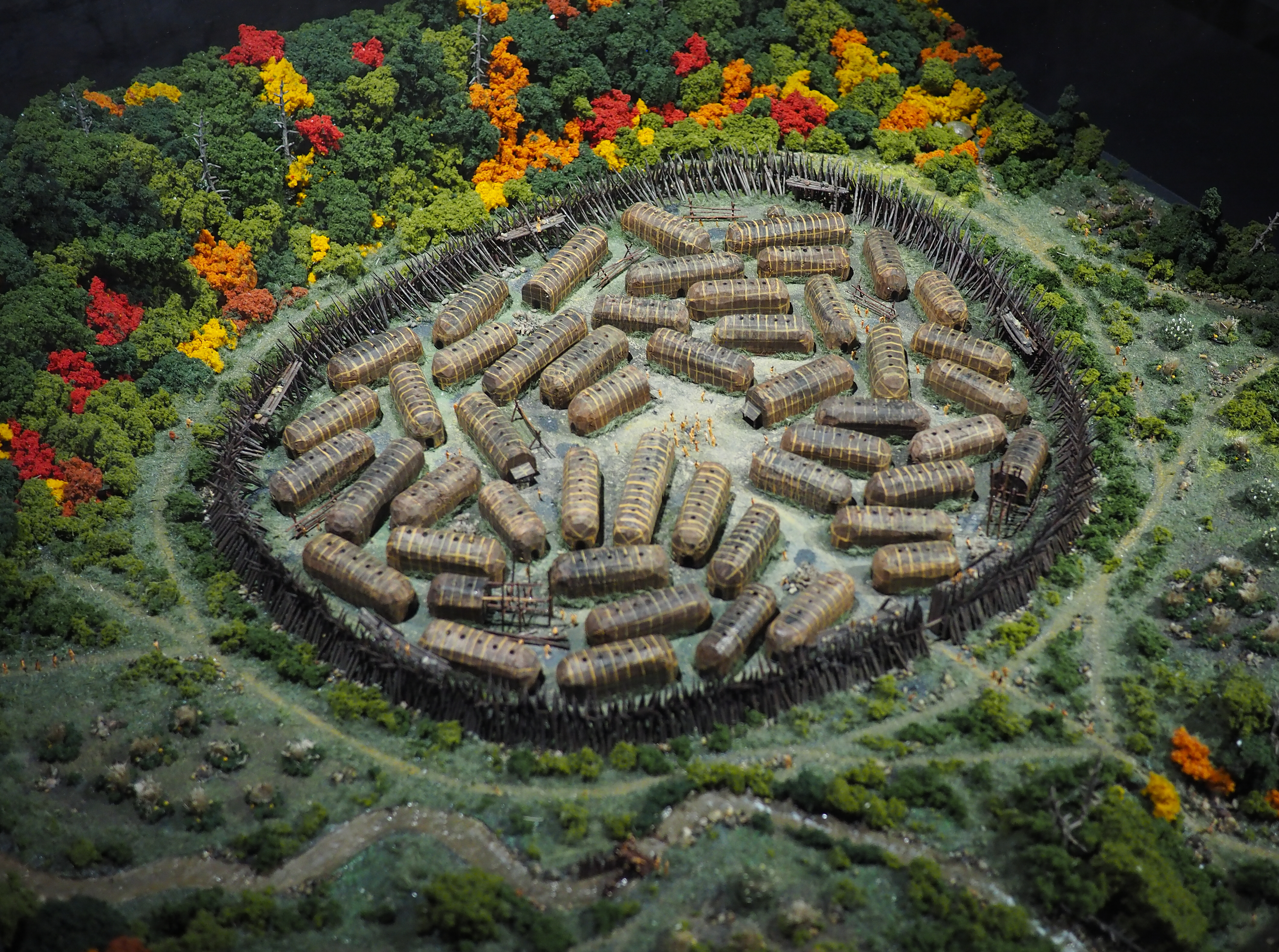
Hochelaga
The name itself is a puzzle. Most linguists trace Hochelaga to an Iroquoian word -- either osekare, meaning "beaver path" or "beaver dam," or osheaga, meaning "big rapids," a nod to the churning Lachine Rapids nearby. The Mohawk people upriver at Kahnawake prefer a different reading: "people of the shaking hands," a name they say arose from the bewilderment of watching Jacques Cartier wave his arms wildly from his boat as he first approached, or perhaps from encountering the strange European custom of the handshake. Whatever the word meant to those who spoke it, the place it named was real and substantial -- a fortified village of some 3,000 souls, ringed by a wooden palisade and surrounded by fields of corn, sitting on or near the mountain that Cartier would christen Mount Royal. That name, of course, became Montreal. The village that inspired it disappeared.
An October Morning in 1535
Jacques Cartier arrived by boat on October 2, 1535, but he waited until dawn the next day to approach the settlement on foot. With twenty marines and the rest of his men, he followed a worn path for about two leagues through rolling terrain until Hochelaga came into view -- roughly fifty longhouses of wood and bark, both rectangular and rounded, enclosed within a wooden palisade. Fields of cultivated corn stretched beyond the walls. The Iroquois greeted him warmly. Their chief raised an arm in welcome, while Cartier responded by raising his own, keeping the other hand on his sword. The scene impressed the French explorer far more than Stadacona, the settlement he had visited downriver near present-day Quebec City. Looking up at the forested peak looming over the village, Cartier declared it Mount Royal -- Mont Real -- in honor of King Francis I of France.
A Village That Vanished
When Cartier returned to the island in 1541, Hochelaga was gone. He mentioned two villages but named only one, Tutonaguy, and made no reference to the thriving settlement he had visited six years earlier. The disappearance has fueled centuries of speculation. War with Stadacona is one possibility. Migration westward toward the Great Lakes is another. Some historians point to devastating conflicts with the Iroquois Confederacy to the south or the Hurons to the west. Old World diseases, arriving with European contact, may have swept through the population. But according to Archeobec, Quebec's archaeological association, the most likely explanation is more mundane: the St. Lawrence Iroquois practiced a cycle of land exhaustion, moving their villages when surrounding soils could no longer sustain their crops. By the time Samuel de Champlain arrived decades later, both Algonquins and Mohawks hunted in the Saint Lawrence Valley and conducted raids, but neither group had established any permanent settlement on the island.
The Search Beneath the City
The exact location of Hochelaga remains one of Montreal's most tantalizing mysteries. William Douw Lighthall championed the Dawson site, discovered in 1860 near McGill University, which appears to correspond to an Indigenous village predating the French founding of Ville-Marie by one or two centuries. But the Dawson site lacked a palisade and seemed too small. Others have proposed Outremont, north of the mountain, arguing Cartier may have arrived via the Riviere des Prairies rather than the Saint Lawrence. Urbanist Pierre Larouche used topometric data from a 16th-century Italian illustration to place the village on the summit of Mount Royal itself -- though Cartier's own writings describe the mountain as adjacent to the village, not beneath it. Archaeological digs on the summit, around the basin, and in Jeanne-Mance Park east of Mount Royal have all come up empty. A stone marker placed in 1925 on land adjacent to McGill University commemorates the former village and is designated a National Historic Site of Canada, though everyone acknowledges it marks an approximation.
Venice Took Notice
Cartier's explorations did not go unnoticed in Europe. Giovanni Battista Ramusio, a Venetian statesman and secretary of the Council of Ten, was consumed by accounts of the New World. Venice, facing a crisis of access to the Indian subcontinent after the Ottoman Turks took Constantinople in 1453, saw potential in every new land discovered. Ramusio obtained a copy of Bref recit, the memoir Cartier had presented to King Francis I in 1545, and included detailed descriptions of the explorer's journeys in the third volume of his work, Delle navigationi et viaggi. The 1556 edition featured illustrations by Giacomo Gastaldi, including La Terra de Hochelaga Nella Nova Francia -- a European-style rendering of Cartier's visit to Mount Royal. A reproduction of this illustration by Paul-Emile Borduas, a member of the avant-garde Refus Global movement, now hangs in the Grand Chalet of Mount Royal Park.
Echoes in the Modern City
Hochelaga's name persists across Montreal in ways both formal and unexpected. The Hochelaga-Maisonneuve neighborhood carries it directly. A variant spelling lives on in the Osheaga Festival, one of Canada's largest music events. The 2017 film Hochelaga, Land of Souls imagines the sweep of history at the village site across the centuries. Even the Canadian sludge metal band Dopethrone titled their fourth album Hochelaga. Beneath all of this -- beneath the university campus, the park paths, the festival stages, and the city streets -- lies the unanswered question that has drawn archaeologists and historians for nearly five hundred years. Somewhere under Montreal, the remains of a fortified village where 3,000 people once lived, farmed, and welcomed a bewildered French explorer still wait to be found.
From the Air
Hochelaga's approximate location sits at 45.5698°N, 73.5381°W, on or near Mount Royal in central Montreal. From the air, Mount Royal is the dominant green hill in the heart of the island city, unmistakable at any altitude. The stone marker near McGill University is on the eastern slope. The nearest major airport is Montreal-Trudeau International (CYUL) approximately 12 nautical miles to the west. For the best perspective on the mountain and the surrounding urban grid that now covers the village site, approach from the south over the Saint Lawrence River at 3,000-4,000 feet AGL.