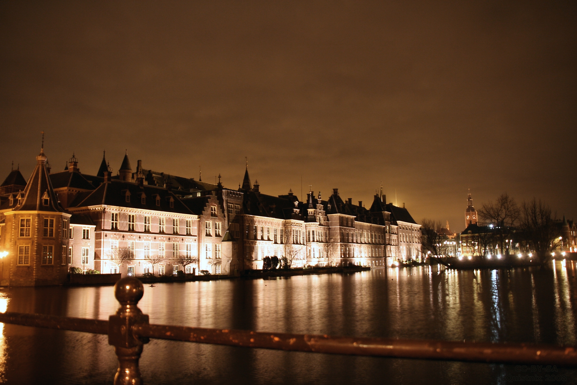
Hofvijver
Stand on the Lange Vijverberg on a still November morning and the Binnenhof appears twice - once in stone, once upside down in the water below. The Hofvijver is not really a pond, despite the name. It is what's left of a dune lake that fed the medieval counts of Holland their drinking water, and it has been holding up a reflection of Dutch power, in one form or another, for almost eight hundred years.
The Lake That Came First
Before there was a city of The Hague, there was a dune lake. Hidden inland from the North Sea coast, it was fed by two creeks running out of the forest - the Haagse Beek and the now-vanished Bosbeek - and the water sat in the natural hollow between sand ridges. The Haagse Beek still feeds the Hofvijver today; the pond is, in a strict hydrological sense, directly connected to the dunes at Kijkduin a few kilometres west. In 1248 William II, Count of Holland and elected king of Germany, picked an island in this lake (or perhaps just the shore - sources disagree) and put up a palace. The city of The Hague counts its founding from that decision. In 1948 the city celebrated its 700th birthday - which dates the pond as both the oldest body of water in The Hague and the reason there is a Hague at all.
Squared Off and Walled In
What started as a curving shoreline did not stay that way. In the 14th century, under Albert I of Bavaria, the lake was straightened into the rectangle you see now. Quays were built in the 17th century. The pond was lengthened in the 19th century. Until around 1800 the Binnenhof itself sat surrounded by water - the Hofvijver was the front moat, and the only way into government was over a drawbridge. The island floating at the centre of the rectangle today was created about three hundred years ago, by no one anyone bothered to record. It has a flagpole, some trees, no public access, and an occasional protest banner. Now and then someone has rowed across and occupied it for an afternoon. Nobody seems to mind.
The Underwater Gate
Look at the corner of the pond closest to the Binnenhof and you will see the Torentje - the Little Tower - a small stone turret jutting into the water. Since 1982 it has held the office of the prime minister of the Netherlands. The window glass is reasonably bullet-resistant. The walls are old and thick. But the water posed a problem nobody had thought about until 2004: someone in scuba gear could swim across the Hofvijver and pop up at the PM's foundations without anyone seeing. So a gate was installed at the lake bed. It is invisible from the bank. It is somewhere underneath the carp.
The Boy on the Bank
On the side of the pond opposite the Binnenhof stands a small bronze figure of a child pointing across the water at the palace. Jantje - Little John - is the subject of a nursery rhyme every Dutch schoolchild learns: a song about a boy from The Hague who lost his ball in a meadow and watched it roll, and roll, into the city. The real Jantje, the historians think, was probably John I, last Count of Holland of the original House of Holland, who inherited the county at age twelve and died at fifteen of dysentery without ever properly ruling. The lonely child-king became a song became a statue became a small boy in bronze standing forever on the bank, finger raised, as if asking the parliament across the pond to give him his ball back.
What the Water Holds
Along the Korte Vijverberg and the Lange Vijverberg, the streets that run along the pond's east and north sides, sit a chain of museums most Dutch cities would build a tourism campaign around: the Mauritshuis with its Vermeers and its Girl with a Pearl Earring; the Gevangenpoort with its 17th-century torture instruments; the Hague Historical Museum; the gallery built by Prince William V, the oldest public art museum in the country. From the water itself, you see only the back facades and the herons. In a hard winter the pond freezes, the prime minister's office looks out over Dutch schoolchildren skating between government buildings, and the Hofvijver does the only thing it has ever really done: hold a mirror up to the country, with a small island floating somewhere in the middle of the reflection.
From the Air
Coordinates 52.0802°N, 4.3118°E. The Hofvijver is a long, dark rectangle of water roughly 200 m east-west and 70 m north-south, immediately north of the Binnenhof courtyard. From the air it is one of the most recognizable features of central The Hague - a perfectly straight-edged rectangle of water with a single small wooded island near its eastern end. Best viewed at 1,500-2,500 ft. The Mauritshuis sits on the southeast corner, and the prime minister's Torentje juts out from the south bank at the western end. Nearest airport: Rotterdam The Hague (EHRD), about 11 nm south.