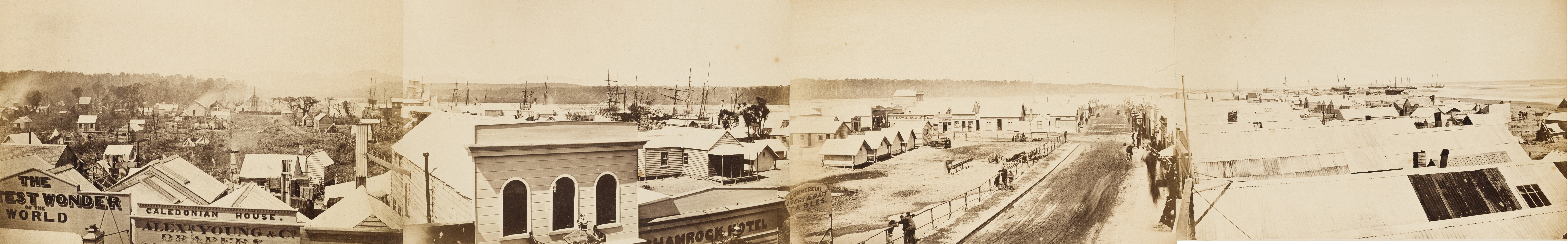
Hokitika
On the 16th of September, 1867, forty-one ships sat alongside the Hokitika wharf. The port ranked first in New Zealand - first in vessels entered, first in total value of exports. The cargo was gold, pulled from the rivers and hillsides of the West Coast in a rush that had swollen this empty stretch of coastline into one of the country's most populous centers in barely three years. Gold does that to a place. It also does what comes next: it leaves. Hokitika today has the quiet bearing of a town that once punched far above its weight and has made peace with a gentler present. The main street still follows the sand dunes that an amateur town planner used as his guide during the rush, resulting in a road so kinked the locals call it the Crooked Mile. Everything else has straightened out. The population dropped. The ships stopped coming. What remained was the landscape that was here before the gold and will be here long after - mountains, rainforest, wild coastline, and the greenstone jade that Maori have valued for far longer than anyone has valued gold.
The Crooked Mile
Revell Street, Hokitika's main commercial strip, does not run straight. When the town was laid out during the gold rush, the planner - an amateur by most accounts - aligned the road with the coastal sand dunes rather than imposing a grid. The result is a street that bends and kinks its way through town, earning the nickname the Crooked Mile. It should have been corrected decades ago, but Hokitika kept the curve, and today it gives the town center a character that grid-planned towns lack. The buildings along Revell Street reflect layers of ambition: the Carnegie Library building now houses the Hokitika Museum, the historic Government Buildings stand as reminders of a time when this was a regional capital of real importance, and the clock tower presides over a commercial district that has traded gold-rush hustle for the slower commerce of jade shops and cafes. The old fire station has been converted into a boutique hotel. Adaptation, not demolition, is the Hokitika way.
The Greenstone Trade
Pounamu - nephrite jade - is found only on the West Coast of the South Island, and its harvest and sale are governed by Ngai Tahu, the local Maori iwi. For Maori, pounamu is taonga, a treasure of deep spiritual and cultural significance, used for tools, weapons, and ornaments for centuries before European contact. Hokitika sits at the center of the pounamu trade today, with jade shops clustered along Weld and Tancred Streets. Buyers need to be alert: some shops sell Canadian jade carved in China, priced attractively but lacking the cultural provenance and geological specificity of genuine West Coast pounamu. For the real thing, the Te Waipounamu Maori Heritage Centre on the corner of Weld and Sewell Streets offers verified pounamu carvings and the chance to watch Ngati Waewae carvers at work, shaping stone that has been pulled from the rivers and mountains of this coast by Maori hands for generations.
Gateway to the Wild West
Hokitika's modern identity is as a staging point. The town sits on State Highway 6, roughly three hours from Christchurch via Arthur's Pass - a drive through the Southern Alps that ranks among New Zealand's most scenic road trips, with kea parrots harassing cars at the summit and the Waimakariri River gorge narrowing the road to a shelf above the rapids. From Hokitika, the highway runs south along the coast toward Franz Josef Glacier, two hours away, and Fox Glacier at two and a half hours. The Hokitika Gorge, with its electric-blue glacial water, lies 40 minutes inland. Greymouth, the West Coast's largest town, is 40 minutes north, with the reconstructed gold-mining settlement of Shantytown along the way. Lake Kaniere offers calm water and bush walks close to town. Hokitika is small enough that most of it can be explored on foot - a half-day's wander covers the main sights - but the surrounding landscape demands weeks.
Quiet After the Rush
The population decline after the gold rush was steep and sustained. Where tens of thousands had crowded the streets and shoreline in the 1860s, modern Hokitika is a town of roughly 3,000. The Westland District's population is growing again, driven by what locals call lifestyle inhabitants - people drawn by affordable land, dramatic scenery, and distance from the pressures of larger cities. Almost 30 percent of the district's ratepayers now live outside Hokitika proper, scattered through the valleys and coastal settlements that surround it. The town has found its equilibrium. It hosts the annual Wildfoods Festival, attracting visitors willing to sample huhu grubs, whitebait patties, and other culinary adventures that the West Coast specializes in. The airport handles small aircraft. Buses connect to Greymouth and Christchurch. The rhythm is unhurried, the weather is wet, and the mountains loom close enough to remind everyone that the landscape - not the town - is the main attraction.
From the Air
Located at 42.72°S, 170.97°E on the West Coast of New Zealand's South Island. Hokitika Airport (NZHK) has a paved runway suitable for small aircraft, situated near the coast north of town. Greymouth, 40 km north, has a larger airport. The town sits at the junction of State Highway 6 (coastal) and State Highway 73 (over Arthur's Pass to Christchurch). From the air, Hokitika is identifiable by its coastal position at the mouth of the Hokitika River, with the Tasman Sea to the west and the Southern Alps rising sharply to the east. The coastline runs roughly north-south here with wide grey sand beaches. Weather is characteristic West Coast: frequent rainfall, low cloud, and variable visibility. On clear days, the Southern Alps ridgeline is visible to the east, with Aoraki / Mount Cook and Mount Tasman prominent to the south-southeast. Lake Kaniere is visible approximately 15 km inland.