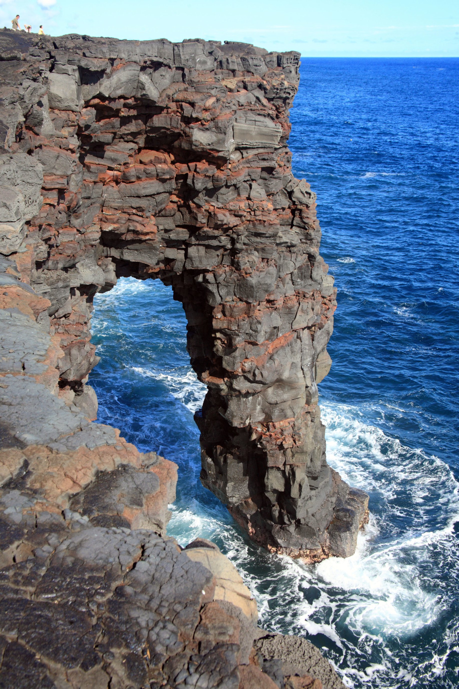
Holei Sea Arch
The Chain of Craters Road used to keep going. It once connected Kilauea's summit caldera to the coast and beyond, but lava flows from the Pu'u 'O'o vent have been burying sections of it since 1990. Today the road simply ends, and at the terminus stands one of the Big Island's most striking geological portraits: the Holei Sea Arch, a 90-foot natural bridge of black basalt where the cliff meets the Pacific. The arch exists because two forces are working on the same rock at different speeds -- Kilauea building the coastline with lava, and the ocean tearing it away with waves.
Lava Meets the Pacific
The Holei Sea Arch is a product of marine erosion working on young volcanic rock. Kilauea's lava flows built these coastal cliffs in layers, and the relentless surf of the Pacific has been carving into them ever since, exploiting weaknesses in the basalt where joints and cooling fractures meet the waves. The result is a soaring natural bridge, its underside hollowed out by the same forces that will eventually destroy it. The arch takes its name from the Holei Pali, the escarpment further upslope on Kilauea's flank -- one of several pali, or cliffs, that mark where the volcanic edifice has fractured and slumped under its own weight. From the arch, the Hilina Pali is visible in the distance, connecting this fragile coastal formation to the much larger story of Kilauea's unstable south flank.
End of the Road
Reaching the arch requires driving the full length of Chain of Craters Road from the Halema'uma'u caldera at Kilauea's summit, a winding descent through volcanic terrain that drops nearly 4,000 feet over roughly 20 miles. The road passes pit craters, old lava flows of varying ages, and petroglyphs carved into the rock by early Hawaiian inhabitants. Where it once continued along the coast, the pavement disappears beneath hardened lava from the Pu'u 'O'o eruption, which began in 1983 and reshaped miles of coastline. The arch stands near this abrupt end, a reminder that the geology here is not ancient history but an ongoing process. Visitors walk a short distance from the parking area to the cliff edge, where the arch is visible below.
A Temporary Monument
Sea arches are inherently impermanent structures. The same erosion that creates them continues to widen the openings until the span becomes too thin to support its own weight, and the bridge collapses into a pile of rubble at the base of the cliff. The Holei Sea Arch, at 90 feet, is dramatic in scale but fragile in geological terms. The surrounding cliffs are steep and undercut, and four people have fallen to their deaths from the overlook area in the past decade. There are no guardrails at the cliff edge -- the terrain is too unstable and the volcanic rock too prone to crumbling for permanent infrastructure. Within Hawaii Volcanoes National Park's Ka'u District, the arch serves as both a tourist attraction and a cautionary illustration of coastal geology in action.
Where Construction Meets Destruction
The Holei Sea Arch captures something essential about the Big Island: it is a place where the planet is simultaneously building and dismantling itself. Kilauea has been adding land to this coastline for centuries, sending rivers of molten basalt into the sea to create new cliffs and black-sand beaches. The Pacific, in turn, has been eating that land back, grain by grain and block by block. The arch is a snapshot of this contest frozen in rock -- for now. Looking north from the overlook, the slopes of Kilauea rise toward the summit, scarred by rift zones and pit craters. Looking south, nothing but open ocean stretches to Antarctica. Between those two vastnesses, the arch stands, a temporary bridge between the fire below and the water ahead.
From the Air
Holei Sea Arch at 19.29°N, 155.10°W, on the southern coast of the Big Island within Hawaii Volcanoes National Park. The arch is visible as a notch in the coastal cliffs at the terminus of Chain of Craters Road. Nearest airport: PHTO (Hilo International Airport), roughly 30 miles to the northeast. The coastal cliffs are approximately 90 ft high. Best viewed from low altitude (1,000-3,000 ft) approaching from the south, where the arch profile is most distinct against the cliff face.