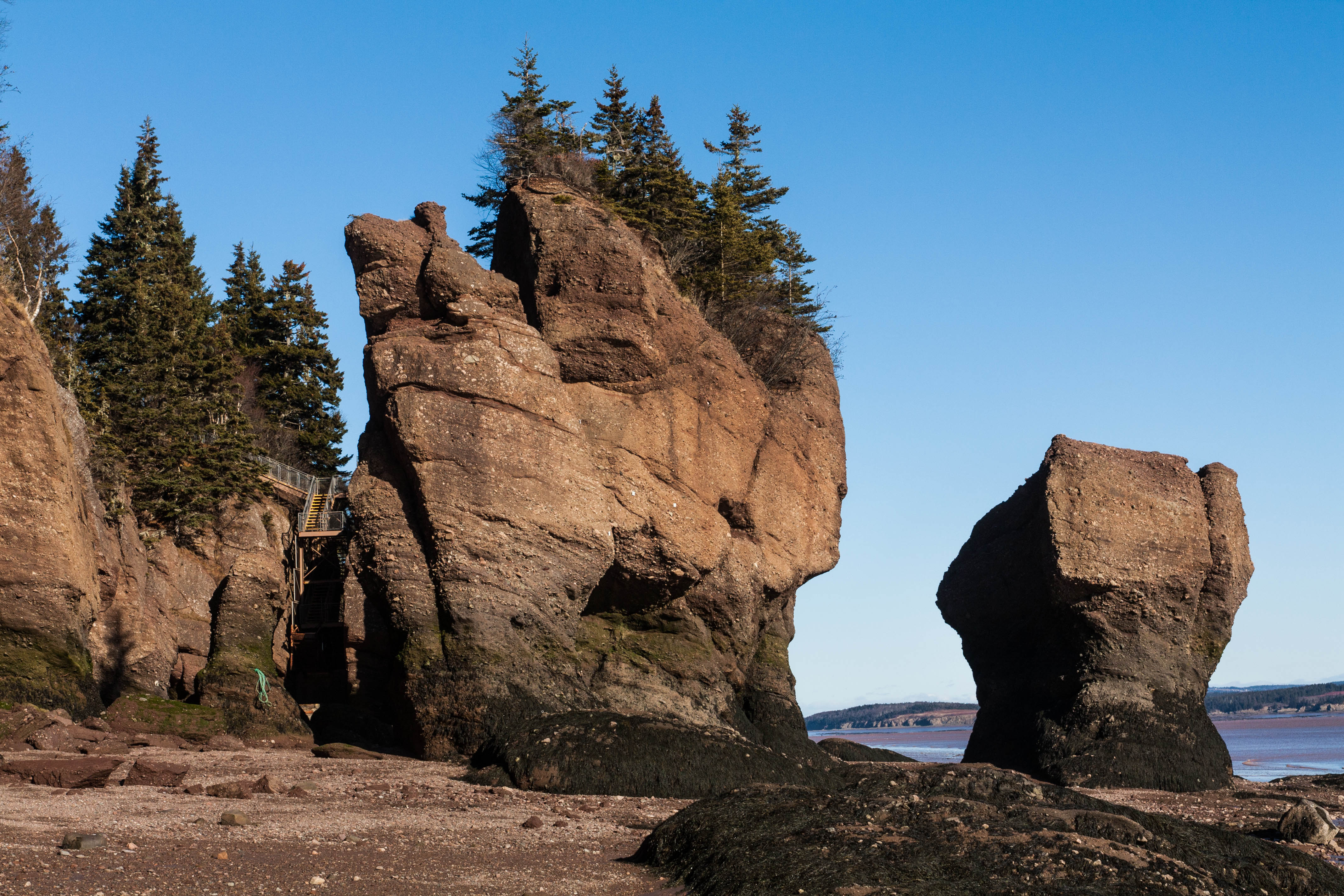
Hopewell Rocks
Twice a day, the ocean floor becomes a hiking trail. At low tide, visitors to Hopewell Rocks walk among towering sea stacks that rise 12 to 21 metres from the red-brown mud, their bases narrowed by centuries of erosion into shapes that earned them the nickname "Flowerpot Rocks." Six hours later, those same formations stand chest-deep or fully submerged in water, as the Bay of Fundy pushes in one of the highest tides on the planet -- up to 16 metres in a single cycle. The transformation is so complete that it can be difficult to believe you are looking at the same place.
Carved by Two Forces
The formations consist of red-brown sedimentary conglomerate, sandstone, and minor mudstone from the Carboniferous-era Hopewell Cape Formation, part of the Mabou Group. Their unusual shapes are the product of two distinct erosive forces working in concert. After glaciers retreated from the region following the last ice age, surface water began filtering through cracks in the cliff face, gradually separating columns of rock from the main wall. Meanwhile, the Bay of Fundy's enormous tidal flows -- driven by the resonance of water sloshing in a basin whose length happens to match the period of the Atlantic tide -- attacked the base of each column more aggressively than the top. Over centuries, this differential erosion sculpted the narrow-waisted pillars and mushroom-capped towers that define the site today. Each formation is temporary by geological standards, still being reshaped with every tide.
The Rhythm of the Bay
The Bay of Fundy moves roughly 160 billion tonnes of water with each tidal cycle, more than four times the combined flow of all the world's freshwater rivers. At Hopewell Cape, near the upper reaches of the bay, this immense volume compresses into increasingly narrow channels, amplifying the tidal range to extraordinary heights. Visitors are advised to stay for a full cycle to appreciate the scale of the change. At low tide, the vast sediment flats support shorebirds that stop here to feed during migration. At high tide, kayakers paddle around the tops of the same formations that hikers touched at their bases just hours before. The daily rhythm is so central to the experience that the provincial park posts tide tables at every entrance, and rangers time their interpretive walks to the water's schedule, not the clock's.
Elephant Rock and the Impermanence of Stone
On March 14, 2016, a formation called Elephant Rock -- named for its resemblance to a pachyderm's profile -- collapsed. Park officials estimated that 100 to 200 tonnes of rock fell to the ground, closing off a passageway where visitors had walked for decades. "Sometime after the tide went out this morning, a significant piece of Elephant Rock calved off," said Kevin Snair, supervisor of interpretive services. The event was a sharp reminder that the very forces creating these formations are also destroying them. A similar collapse struck a formation at the nearby Fundy Trail Parkway in February 2022. The rocks that remain are not permanent monuments but transient sculptures, shaped and eventually consumed by the tides that made them remarkable in the first place.
Between Tides
Hopewell Rocks sits near the end of a chain of Fundy coastal attractions that includes Fundy National Park and the Fundy Trail, making it part of a larger story about New Brunswick's relationship with the sea. But where the national park offers wilderness hiking and deep river gorges, Hopewell Rocks offers something more intimate: a direct, tactile encounter with geological time. You can place your hand on Carboniferous-era stone, feel the gritty surface where conglomerate pebbles protrude from the matrix, and look up at a formation that has been standing since before humans walked this continent. Then you can return in six hours and watch that same stone vanish beneath the Atlantic. Few natural landmarks make the power of moving water this visible, or this personal.
From the Air
Located at 45.82°N, 64.57°W at Hopewell Cape on the upper Bay of Fundy, New Brunswick. The sea stacks are visible along the shoreline at low altitude. Nearest airports: Greater Moncton (CYQM) approximately 30 nm northeast, Saint John (CYSJ) approximately 55 nm southwest. The dramatic tidal flats and red-brown rock formations contrast with surrounding forest. Best viewed at 1,500-3,000 feet AGL; at low tide the exposed ocean floor and standing formations are clearly visible from the air.