Horn of Africa
The ancient Romans called it Regio Aromatica -- the Land of Spices -- for the frankincense, myrrh, and cinnamon that flowed from its ports. The ancient Egyptians called parts of it Ta Netjer, God's Land, and sent expeditions here to bring back incense for their temples. Today it is the Horn of Africa: the fourth-largest peninsula in the world, a dagger of land extending hundreds of kilometers into the Indian Ocean where the Red Sea meets the Gulf of Aden. It encompasses Somaliland, Somalia, Djibouti, Ethiopia, and Eritrea -- five countries whose intertwined histories stretch back to the earliest chapters of human civilization.
Where Humanity Walked Out
The Horn of Africa is not just old. It is foundational. Stone-tipped projectiles found in the Ethiopian Rift Valley date to more than 279,000 years ago, placing the region among the earliest sources of modern human culture and technology. According to the Southern Dispersal theory, early humans left Africa through the Horn, crossing the Bab el-Mandeb strait -- today 12 miles wide, but far narrower 50,000 years ago when sea levels were 70 meters lower. Shell middens 125,000 years old found in Eritrea suggest that the diet of these early populations already included seafood gathered by beachcombing. The region also gave the world two staples that endure: teff, the seed grass domesticated between 4000 and 1000 BCE and used to make the Ethiopian flatbread injera, and coffee, which originated in Ethiopia's highlands before spreading across the globe.
Empires at the Crossroads
Geography made the Horn a crossroads, and trade made it wealthy. The Kingdom of Aksum, thriving between the first and seventh centuries CE, minted its own currency and controlled commerce between the Roman Empire and India. Under Emperor Ezana in the fourth century, Aksum became one of the first major empires to adopt Christianity. To its south and east, Somali city-states like Opone, Mosylon, and Malao competed with Sabaeans, Parthians, and Axumites for control of the Indo-Greco-Roman trade. The arrival of Islam transformed the coast: ancient ports became the Islamic cities of Mogadishu, Berbera, Zeila, and Barawa, with Mogadishu earning the title "City of Islam" and controlling the East African gold trade for centuries. During the Middle Ages, the Adal Sultanate, the Ajuran Sultanate, and the Ethiopian Empire shaped the region through warfare, commerce, and architectural ambition -- leaving behind courtyard houses, mosques, walled enclosures, and hundreds of ruined castles scattered across the Somali landscape.
The Colonial Fracture
The opening of the Suez Canal in 1869 turned the Horn into a prize for European powers scrambling for coaling stations and strategic coastline. Italy seized Eritrea in 1890 and eventually, under Mussolini, conquered Ethiopia in 1936. France carved out Djibouti. Britain established protectorates in Somaliland and along the Gulf of Aden. Against these incursions, local resistance was fierce. Mohammed Abdullah Hassan's Dervish movement held the British at bay for a quarter century before being crushed by aerial bombardment in 1920. In Ethiopia, Emperor Haile Selassie's appeal to the League of Nations after Italy's invasion made him Time magazine's Man of the Year in 1935 and a symbol of African sovereignty. The colonial borders drawn by European powers -- often with little regard for clan territories or ethnic boundaries -- created the fault lines along which the region's modern conflicts still run.
Rift and Resilience
The landscape itself is a story of deep geological violence. The Horn sits atop the Great Rift Valley, a fissure in the earth's crust stretching from Turkey to Mozambique, marking where the African and Arabian tectonic plates are pulling apart. Eighteen million years ago, the Horn and Yemen were a single landmass; the Gulf of Aden rifted them apart. In Ethiopia's highlands, rainfall exceeds 2,000 millimeters per year, feeding the Nile and sustaining dense agriculture. But on the eastern coast, a cold offshore current and parallel winds suppress rainfall to as little as 50 millimeters annually. Somalia has only two permanent rivers, the Jubba and the Shabele, both born in the Ethiopian Highlands. This contrast -- lush highlands and parched lowlands -- has shaped everything from migration patterns to the pastoral economies that still drive more than 95 percent of the region's cross-border trade.
A Living Mosaic
More than 220 mammal species inhabit the Horn, including the endangered Grevy's zebra, the Somali wild ass, and the hamadryas baboon -- the same species that ancient Egyptians imported from Punt. The region holds more endemic reptiles than any other part of Africa, with over 285 species and about 90 found nowhere else. On the island of Socotra, off Somalia's coast, half the endemic genera of reptiles exist in isolation. The human diversity is equally rich: the people of the Horn speak languages from the Cushitic, Semitic, Omotic, Nilo-Saharan, and Niger-Congo families. The region produced the Ge'ez script, in use for at least 2,000 years, and the Osmanya alphabet, a phonetically sophisticated writing system devised in the early twentieth century for the Somali language. It is a region where livestock markets in the Somaliland towns of Burao and Yirowe move 10,000 sheep and goats daily, bound for Gulf state ports via Berbera -- unofficial commerce worth an estimated $250 to $300 million per year.
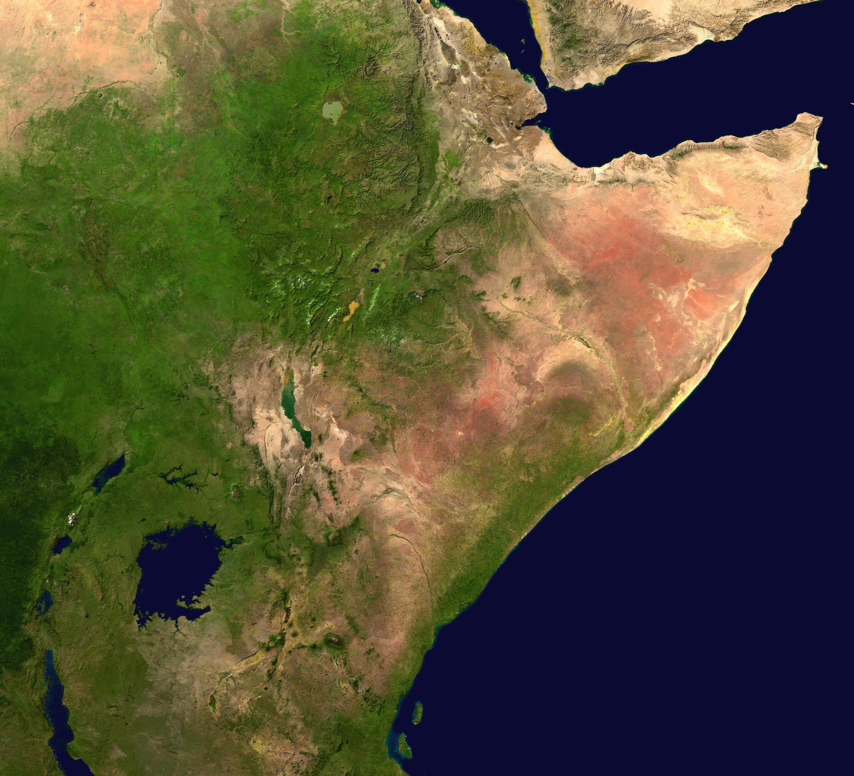
From the Air
The Horn of Africa extends from approximately 2°N to 15°N latitude and 36°E to 51°E longitude. The peninsula's distinctive shape is clearly visible from altitude, jutting eastward into the Indian Ocean. Major airports include Addis Ababa Bole (HAAB), Mogadishu Aden Abdulle (HCMM), Djibouti-Ambouli (HDAM), Asmara International (HHAS), and Hargeisa Egal (HCMH). The Great Rift Valley is a prominent geological feature visible from cruising altitude, as is the Bab el-Mandeb strait at the southern end of the Red Sea.