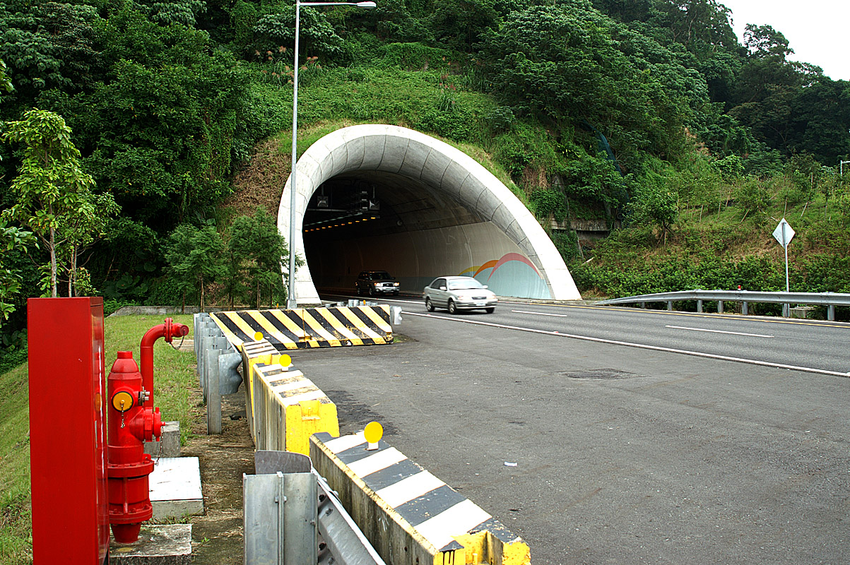
Hsuehshan Tunnel
For most of Taiwan's history, the eastern coast was somewhere you got to slowly. The Xueshan Range, a wall of peaks running down the island's spine, separated Taipei and the densely populated western plain from Yilan County and the Pacific shore. Drivers wound through mountain passes. The journey took two hours on a good day, longer in the typhoon season rains that are routine in this part of the world. Then, on June 16, 2006, a tunnel opened through the mountain, and what had been a two-hour ordeal became a thirty-minute drive. The Hsuehshan Tunnel is Taiwan's longest highway tunnel - nearly thirteen kilometers of bored rock connecting National Freeway 5 from Pinglin District in New Taipei City to Toucheng Township in Yilan County. Building it consumed fifteen years, 370,000 cubic meters of concrete, and NT$18.5 billion. It also transformed the economic geography of the island.
Fifteen Years Through the Mountain
Construction began with a pilot tunnel in July 1991. The main tunnels - one for each direction of traffic - broke ground on July 23, 1993. What followed was a decade and a half of engineering struggle against some of the most challenging geology in East Asia. The Xueshan Range is geologically young and unstable, riddled with fault zones, fractured rock, and groundwater under enormous pressure. Tunnel boring machines, designed for more cooperative stone, repeatedly stalled or were damaged. Water flooded the work face. Progress was measured in meters per month rather than meters per day. The pilot tunnel did not break through until October 2003 - twelve years after it started. The northbound main tunnel followed in April 2004, the southbound in September of the same year. Two more years of finishing work followed before the tunnel opened to traffic. The total cost reached NT$90.6 billion, roughly US$2.83 billion, making it one of the most expensive infrastructure projects in Taiwan's history.
Bridging Two Taiwans
The tunnel's purpose was not merely to shorten a commute. Ninety-five percent of Taiwan's population lives on the western side of the island, concentrated in the corridor from Taipei through Taichung to Kaohsiung. The eastern coast - Yilan, Hualien, Taitung - remained comparatively undeveloped, cut off by mountains that made daily economic integration impossible. The Hsuehshan Tunnel was designed to begin correcting that imbalance, connecting the capital directly to a region that had long felt peripheral. The effect was immediate. Yilan, once a quiet agricultural county where Taipei residents vacationed on long weekends, became a viable commuter destination. Property values shifted. Tourism surged. The hot spring resorts and seafood restaurants of the Yilan coast suddenly sat within easy reach of a metropolitan area of seven million people. The rural district of Pinglin, which had relied on through-traffic from the old mountain road, found itself bypassed entirely - a reminder that infrastructure rearranges winners and losers as readily as it moves cars.
Rules of the Passage
Driving through nearly thirteen kilometers of tunnel at highway speed requires discipline, and the Hsuehshan Tunnel enforces it rigorously. The speed limit is 90 km/h, with a minimum of 70 km/h to prevent dangerous speed differentials. Vehicles must maintain at least 50 meters of separation, reduced to 20 meters only during heavy congestion. Lane changes are prohibited along the entire length - double solid lines run from entrance to exit. Automated enforcement cameras monitor for speeding, tailgating, and illegal lane changes. When the tunnel first opened, authorities announced zero tolerance for speeding, meaning that driving even 1 km/h over the 70 km/h limit triggered a fine. The resulting public outcry led to a policy adjustment three months later: a tolerance of 10 km/h was introduced in September 2006, and the overall limit was later raised to 90 km/h in November 2010 to improve traffic flow. Three ventilation shafts punctuate the tunnel's length, circulating fresh air through a passage that carries tens of thousands of vehicles daily.
The Mountain Above
From the air, the tunnel is invisible - its entire length lies beneath the Xueshan Range, one of the highest mountain chains in northeastern Asia. The entrance portal on the western side sits in Pinglin District, a tea-growing area known for Baozhong oolong. The eastern portal emerges in Toucheng Township, where the mountains drop abruptly toward the Pacific. Between them lies nearly thirteen kilometers of engineered void: the northbound tunnel at 12,942 meters, the southbound at 12,917 meters, and the pilot tunnel at 12,941 meters. The three parallel bores run through rock that fought every meter of their construction. Above, the mountains continue as they have for millennia, indifferent to the river of headlights flowing through their foundations. The tunnel carries no scenic views, no overlooks, no sense of the landscape it traverses. But it carries something else: the daily proof that geography, given enough concrete and enough years, can be negotiated.
From the Air
Located at 24.94°N, 121.72°E, the Hsuehshan Tunnel passes beneath the Xueshan Range connecting Pinglin District (west portal) to Toucheng Township (east portal) on National Freeway 5. The tunnel itself is invisible from the air, but the freeway approaches on both sides are visible, particularly the eastern portal where the highway emerges near the coast. The Xueshan Range rises to over 3,800m at its highest peaks to the south. Taipei Songshan Airport (RCSS/TSA) is approximately 30km to the northwest. Taiwan Taoyuan International Airport (RCTP/TPE) is about 60km to the west. The Yilan Plain is visible to the east of the tunnel exit, a broad flat area between the mountains and the Pacific coast. Weather frequently includes low cloud and rain, particularly on the eastern (Yilan) side of the range.