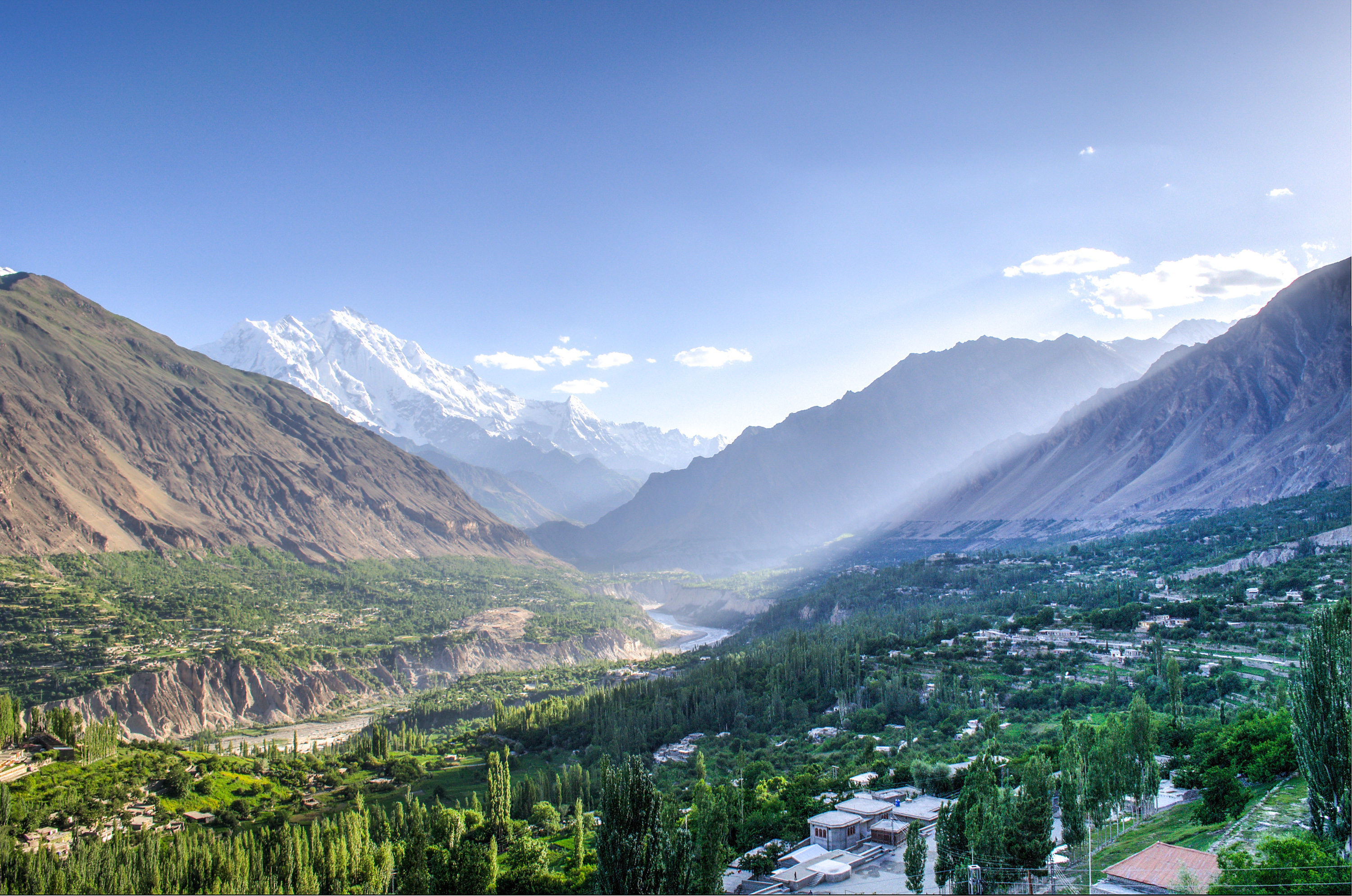
Hunza Valley
James Hilton never confirmed it, but the suspicion has lingered since 1933: the mythical valley of Shangri-La in his novel Lost Horizon was inspired by Hunza. It is easy to see why. Wedged between the Karakoram and the Hindu Kush in Gilgit-Baltistan, Pakistan, the Hunza Valley sits at 2,438 meters on the floor of a corridor so spectacular that the landscape itself reads like fiction. Peaks exceeding 7,000 meters ring the horizon in nearly every direction. The 57-kilometer Batura Glacier, the fifth-longest outside the polar regions, presses down from the north. And yet the valley floor is green, terraced, and alive with apricot orchards whose blossoms turn the entire basin pink each spring.
Nine Centuries of Independence
Hunza was not always part of Pakistan. For more than 900 years it existed as an independent principality, its rulers bearing the title Mir. The state bordered Afghanistan's Wakhan Corridor to the north, China's Xinjiang to the northeast, and the rival princely state of Nagar to the east. Its capital, Baltit -- now known as Karimabad -- still crowns a ridgeline above the valley, anchored by the 800-year-old Baltit Fort. Below it sits Altit Fort, even older, and the ancient settlement of Ganish Village, whose name derives from the Hindu deity Ganesh, a remnant of the valley's pre-Islamic past. In the early 1800s, Hunza became entangled in the British "Great Game" for Central Asian influence. By 1891 the British Empire had captured the valley, and its Mir, Safdar Ali Khan, fled to Kashgar in China. His brother was installed as a puppet ruler. The principality endured in diminished form until 1974, when Zulfikar Ali Bhutto dissolved it for good.
Monks, Merchants, and the Silk Road
Long before the Mirs, before Islam arrived and the majority of the population converted to the Ismaili sect they follow today, this valley belonged to Buddhism. Rock inscriptions in ancient Brahmi script still mark the cliffs, carved by monks who passed through on the Silk Road from South Asia to Central Asia. The Sacred Rock of Hunza preserves some of the region's most important Buddhist archaeological evidence. Traders and their caravans once followed these same routes, connecting Ladakh and Kashmir to distant markets in Yarkand and Baltistan. For centuries, the valley was both a waypoint and a sanctuary -- protecting Buddhist missionaries while profiting from the commerce they attracted. When Islam took hold, the inscriptions were largely forgotten or vandalized, but restoration efforts are now reclaiming them as cultural heritage.
A Landscape of Extremes
The scale of the Hunza Valley resists easy comprehension. Rakaposhi rises to 7,788 meters. Ultar Sar reaches 7,388 meters. Ladyfinger Peak, at 6,000 meters, is considered one of the valley's lesser summits. The turquoise expanse of Attabad Lake, which did not exist before January 4, 2010, adds a surreal counterpoint to the ancient geology. That morning, a massive landslide killed 20 people, buried 26 kilometers of the Karakoram Highway, and dammed the Hunza River. The water backed up into a lake 30 kilometers long and 120 meters deep. Sections of the highway remain submerged. Travelers now cross Attabad Lake by boat, an accidental transit through one of the most dramatic landscapes on earth. Farther north, the Khunjerab Pass stands at 4,693 meters -- the highest paved international border crossing in the world, linking Pakistan to China.
The Hunza People
Three languages coexist in the valley: Burushaski, Wakhi, and Shina. Burushaski is a language isolate, unrelated to any other known tongue -- a linguistic mystery that mirrors the valley's geographic isolation. The literacy rate exceeds 95 percent, a figure that owes much to community schools supported by the Aga Khan Development Network, which has invested heavily in education here, particularly for girls. Legends of extraordinary Hunza longevity have circulated for decades, fueled by claims that residents routinely live past 100. The truth is more complicated. Researchers like John Clark, who spent extended time with the Burusho people, found no evidence of exceptional lifespan, and skeptics point to the absence of reliable birth records. What is less debatable is the lifestyle: a diet rich in apricots, walnuts, and fresh vegetables, combined with the relentless physical demands of farming terraced fields at altitude, produces a population that is remarkably active and lean.
The Road In
The Karakoram Highway -- one of the highest paved roads on earth -- is the valley's lifeline and its greatest engineering feat. It traces the Hunza River through gorges so narrow the road was blasted from solid rock. Despite the landslide damage at Attabad, the highway still connects Hunza to Gilgit in the south and to China's Xinjiang region through the Khunjerab Pass. For most visitors, the journey begins in Gilgit and climbs steadily northward through a landscape that shifts from dry scrubland to lush terraced orchards in the space of a few kilometers. The valley divides into three distinct zones: Lower Hunza, known as Shinaki; Central Hunza, where Karimabad and the great forts cluster; and Upper Hunza, or Gojal, which stretches toward the Chinese border. Each has its own character, its own microclimate, and its own dialect. Together, they form a corridor that has channeled travelers, monks, soldiers, and traders for millennia.
From the Air
Located at 36.32°N, 74.65°E in the Karakoram Range of Gilgit-Baltistan, Pakistan. The valley floor sits at approximately 2,438 m (8,000 ft), but surrounding peaks exceed 7,000 m, so approach with caution. Rakaposhi (7,788 m) is a dominant visual landmark to the south. The turquoise Attabad Lake and the Karakoram Highway threading the valley are visible from altitude. The nearest airport is Gilgit Airport (OPGT), approximately 100 km south. Khunjerab Pass (4,693 m) marks the Chinese border to the north. Weather can be volatile; clear mornings offer the best visibility.