Huriawa Peninsula
The spring is what saved them. Hidden somewhere on this rocky headland, Te Punawai a Te Wera kept fresh water flowing to the defenders of Huriawa pa while their enemies camped on the narrow isthmus and waited for thirst to do what force could not. Six months later, the besiegers gave up and went home. The spring still flows, and Huriawa Peninsula still juts defiantly into the Pacific, a steep finger of rock stretching a kilometre east from the mouth of the Waikouaiti River, 35 kilometres north of Dunedin on the Otago coast.
The Turning River
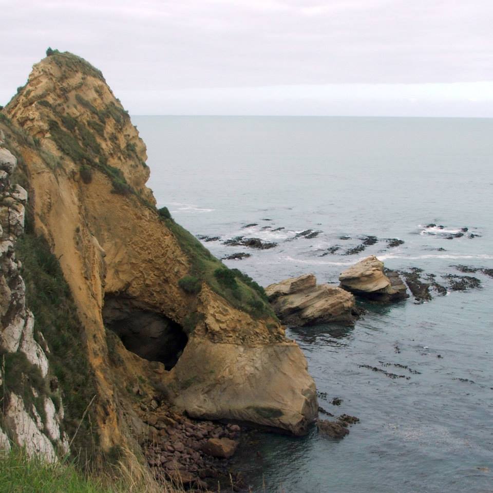
The name tells the story of a landscape in motion. Huriawa is a Maori term meaning "turning river," and it refers to an older geography: the Waikouaiti River once emptied into the sea south of the peninsula before shifting its course to the north. That shift left Huriawa flanked by water on nearly every side. Sheer cliffs line the southern coast, where the open ocean has carved blowholes and isolated rock pinnacles from the headland's edge. The northern shore, facing the river estuary, is gentler but still steep. At the peninsula's western base, where it meets the mainland at Karitane, the connecting isthmus narrows to roughly ninety metres. Across the river mouth, a long sandspit forms the southern end of Waikouaiti Beach. It is a landscape shaped by the contest between river and sea, and that contest made Huriawa one of the most naturally defensible sites on the Otago coastline.
Te Wera's Stronghold
In the years before Captain James Cook's arrival in New Zealand in the late eighteenth century, Kai Tahu chief Te Wera established a pa on the peninsula that bore his name. The fortification exploited everything the landscape offered: cliffs too steep to scale, an isthmus too narrow to assault in force, and the concealed freshwater spring that would prove decisive. When Te Wera's cousin Taoka laid siege to the pa, the defenders held firm. Month after month, Taoka's forces waited on the isthmus for starvation or thirst to weaken the garrison. Neither came. Te Wera's people had prepared thoroughly, and the spring kept them supplied with fresh water throughout the ordeal. After six months, the siege broke. The confrontation was one of several battles between the two chiefs that ranged along the coastline from Timaru to the mouth of Otago Harbour, but the defence of Huriawa stands as the most dramatic. In 1998, the peninsula was returned to Ngai Tahu under the Treaty of Waitangi settlement, and it became the first place in Otago registered as wahi tapu by the New Zealand Historic Places Trust.
Where the Gospel First Sounded
Walk across the isthmus today and you pass Karitane cemetery, where a memorial marks a different kind of first. On 17 May 1840, Reverend James Watkin of the Wesleyan mission delivered the first Christian sermon given in Otago. Watkin had arrived at Waikouaiti to establish the first mission station of any denomination in the South Island, and he made a deliberate choice: rather than settle among the small European community across the bay, he set up house at Karitane, among the Maori community he had come to serve. Over the four years he spent at Karitane, Watkin baptised more than 258 people and married 39 couples. He learned Maori, built relationships, and planted the seeds of a faith community that would outlast his short tenure. The memorial on the isthmus stands at the junction of two histories, Maori and European, layered on the same narrow strip of land.
Thirteen Hectares of Deep Time
Huriawa Historic Reserve covers 13.32 hectares of the peninsula today, managed as a place where ecological and cultural values overlap. The walking track that crosses the headland passes through coastal scrub and tussock, with views north to Waikouaiti Beach and south along the rugged ocean cliffs. Seabirds nest on the rock pinnacles. Below the clifftops, the blowholes thunder when swell runs high, sending plumes of spray through fissures in the rock. The land is owned by Kati Huirapa Runaka ki Puketeraki, and guided cultural tours offered by Karitane Maori Tours connect visitors to the stories embedded in the landscape. It is private land, treated with the respect due to a wahi tapu site, and the experience of walking it is shaped as much by what you learn as by what you see. The peninsula does not shout for attention. It waits, as Te Wera's defenders waited, for those willing to come to it on its own terms.
From the Air
Huriawa Peninsula is at 45.64S, 170.67E, projecting east from the mouth of the Waikouaiti River on the Otago coast. The narrow isthmus connecting it to Karitane is visible from 2,000-3,000 feet AGL, and the southern cliffs, blowholes, and rock pinnacles are best appreciated from a southerly approach at lower altitudes. The nearest airport is Dunedin (NZDN), approximately 35 km to the south. Oamaru Airport (NZOU) lies about 50 km to the north. Waikouaiti Beach and its long sandspit are prominent landmarks on the northern side of the river mouth. Coastal fog can reduce visibility, particularly in the early morning.