Idrakpur Fort
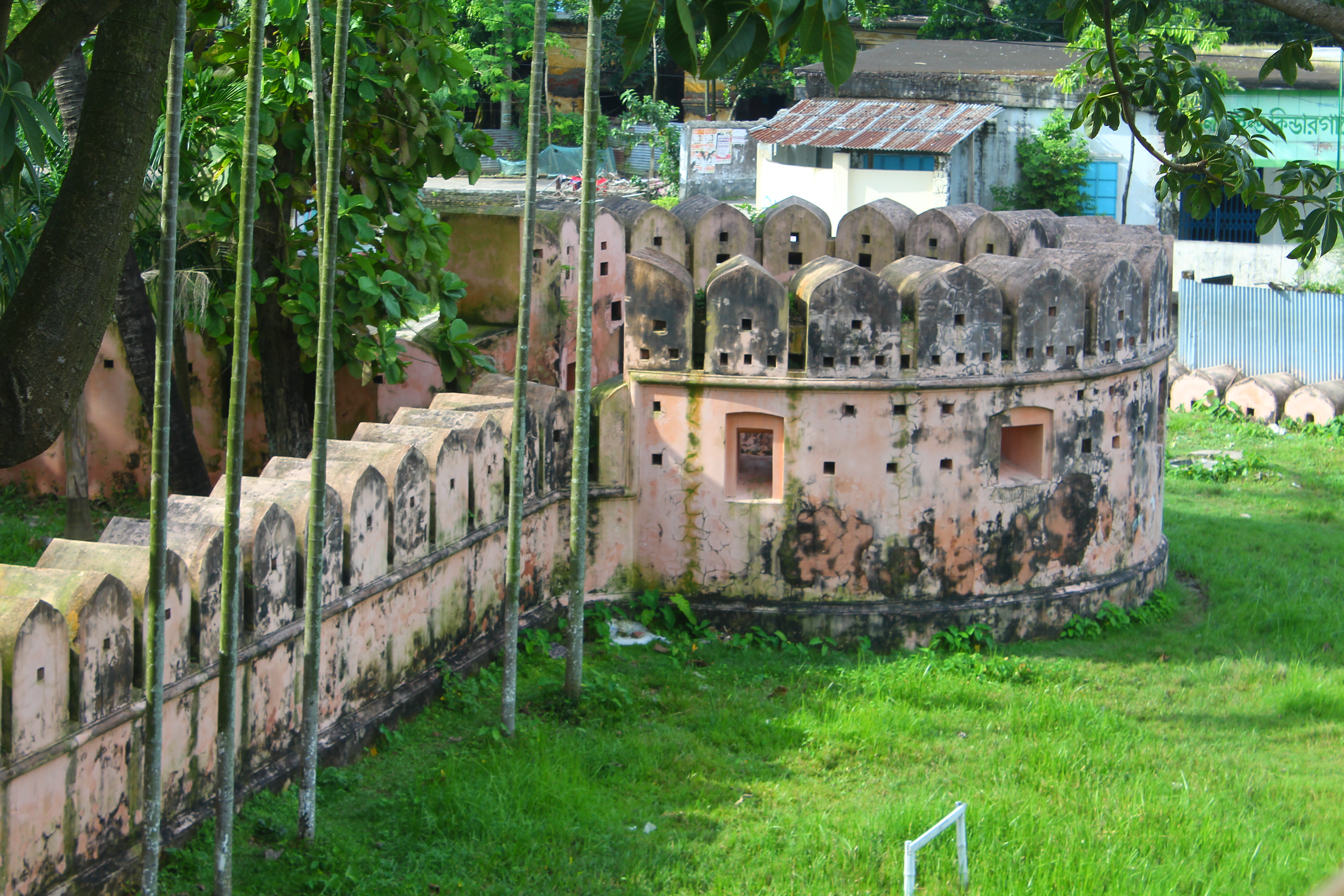
Beneath the drum tower of Idrakpur Fort, a staircase descends to a secret underground chamber. It was the magazine - a storehouse for arms and explosives - and according to local legend, the staircase once connected through a tunnel all the way to Lalbagh Fort in Dhaka, some 25 kilometers to the north. Whether the tunnel ever existed is debatable. What is certain is that when Mir Jumla II built this brick fortress around 1660, he was thinking in terms of exactly that kind of strategic connectivity. Idrakpur was not a standalone fortification. It was one corner of a triangle.
A Governor Who Understood Rivers
Mir Muhammad Saeed Ardestani - known to history as Mir Jumla II - came to Bengal as a problem solver. Emperor Aurangzeb needed someone with naval expertise to govern a province where rivers served as highways and waterborne raiders terrorized prosperous cities. Mir Jumla was an inspired choice: before entering Mughal service, he had been a successful maritime trader. After forcing Shah Shuja, the previous Subahdar, to retreat during the war of succession following Shah Jahan's decline, Mir Jumla was appointed governor of Bengal in 1660. One of his first acts was shifting the provincial capital from Rajmahal to Dhaka - a decision that placed the seat of Mughal power at the nerve center of Bengal's river network. Then he turned to the problem of pirates.
The Triangle Against Terror
Portuguese and Magh pirates had terrorized Bengal for generations, using the river system to strike deep into the province's interior. Traveling up the Shitalakshya River toward Dhaka, they looted the wealthy cities of Sonargaon and Bikrampur along the way. Mir Jumla's solution was geometric: three river forts positioned to create a triangular defense net around Dhaka's southern approaches. Idrakpur Fort guarded the junction of the Ichhamati and Meghna Rivers in Munshiganj. The Hajiganj Fort and Sonakanda Fort covered approaches from Narayanganj. Together, the three fortifications created overlapping fields of fire across the river routes that pirates depended on, transforming Bengal's waterways from vulnerabilities into kill zones.
Walls Built to Watch Water
The fort's architecture reveals its riverine purpose. The thick brick walls run 86.87 meters from north to south and 59.60 meters in width, enclosing a wide-open interior surrounded by bastions at each angle. Machicolations punctuate the walls - openings through which defenders could fire mortars and target enemies on the water below. Watchtowers allowed sentries to track movement along the rivers. The drum tower, the fort's most distinctive feature, comprises three subsequent layers and houses the entrance to that secret underground chamber. The main gate faces north, protected by a high rectangular bastion crowned with machicolated merlons that served as a guard room. Every element was designed with one purpose: to see what was coming up the river and to stop it.
From Pirate Defense to Heritage Site
The Mughals had taken control of Bengal in 1574 after defeating Daud Khan Karrani, and for nearly two centuries they poured resources into governing what was among their wealthiest provinces. The pirate threat was persistent precisely because Bengal's wealth made it worth raiding. Idrakpur Fort endured through the end of Mughal authority, through the British colonial period, and through the independence of Bangladesh. Today it stands in Munshiganj as one of the country's recognized archaeological sites - a brick monument to a time when the defense of a capital city depended not on walls around the city itself, but on forts positioned along the rivers that enemies had to travel to reach it. The strategic logic of Mir Jumla's triangle remains legible in the landscape, with all three forts still standing.
From the Air
Located at 23.55°N, 90.53°E in Munshiganj, Bangladesh, at the historic junction of the Ichhamati and Meghna Rivers. The fort is approximately 25 km south-southeast of Dhaka. Hazrat Shahjalal International Airport (VGHS/DAC) is the nearest major airport, roughly 30 km to the north-northwest. From the air, the fort's rectangular brick walls are visible amid the dense settlement of Munshiganj town. The Meghna River, one of Bangladesh's great waterways, dominates the eastern landscape. Best viewed at 2,000-3,000 ft to appreciate the fort's relationship to the river junction it was built to defend.