IJtunnel
For most of Amsterdam's history, the IJ was a wall. The river-arm runs east-west through the city like a slash mark, and the centre, the canals, the Dam, the train station, everything tourists picture when they picture Amsterdam, all sits on the south bank. To the north, across the water, lay villages, ship slips, polder, and eventually the borough of Amsterdam-Noord, hard to reach without a ferry. In the early 1960s the engineers gave up arguing for a bridge and started building underneath instead. The IJtunnel opened on 30 October 1968. It is 1,682 metres long counting its approaches, 1,039 metres of which are roofed; its deepest point lies 20.32 metres below sea level. Cars sometimes don't realise they are under a river at all.
Building It in the Dry
An immersed-tube tunnel is built in pieces on land and floated into place. Rectangular concrete segments, each 24.8 metres long and 8.75 metres wide, were cast in a dry dock, sealed, towed out into the IJ, and lowered into a trench dredged across the river bed. Once positioned and joined, the trench was backfilled, the seals broken, and the resulting tube became a continuous road. Inside each segment, two tubes run side by side for traffic; a narrower tube between them carries cables and pipes. The technique was already standard for underwater road tunnels by the 1960s, but the IJ presented its own complications: an active shipping channel above, soft alluvial mud below, and the need to hand the city, on the day of opening, a route through one of the busiest stretches of port-adjacent water in the country.
Air, Light, and 22 Cameras
Two ventilation buildings stand on the banks, one north and one south, pulling polluted air out of the tunnel and pushing clean air in through vents that open in the tunnel walls just above road height. Closed-circuit cameras, twenty-two of them, watch the lanes around the clock. A heating system runs beneath the road surface to keep ice from forming inside the cold concrete throat. At each end of the tunnel a computer adjusts the lighting in stages, brightening or dimming the interior so that drivers' eyes have time to adjust between tunnel light and daylight. At the south entrance, the NEMO Science Museum building, Renzo Piano's green copper ship-shape, sits directly on top of the tunnel. From the air it looks as though a ship has run aground on the city's edge. From inside the tunnel, of course, you cannot see it at all.
Who's Allowed Through
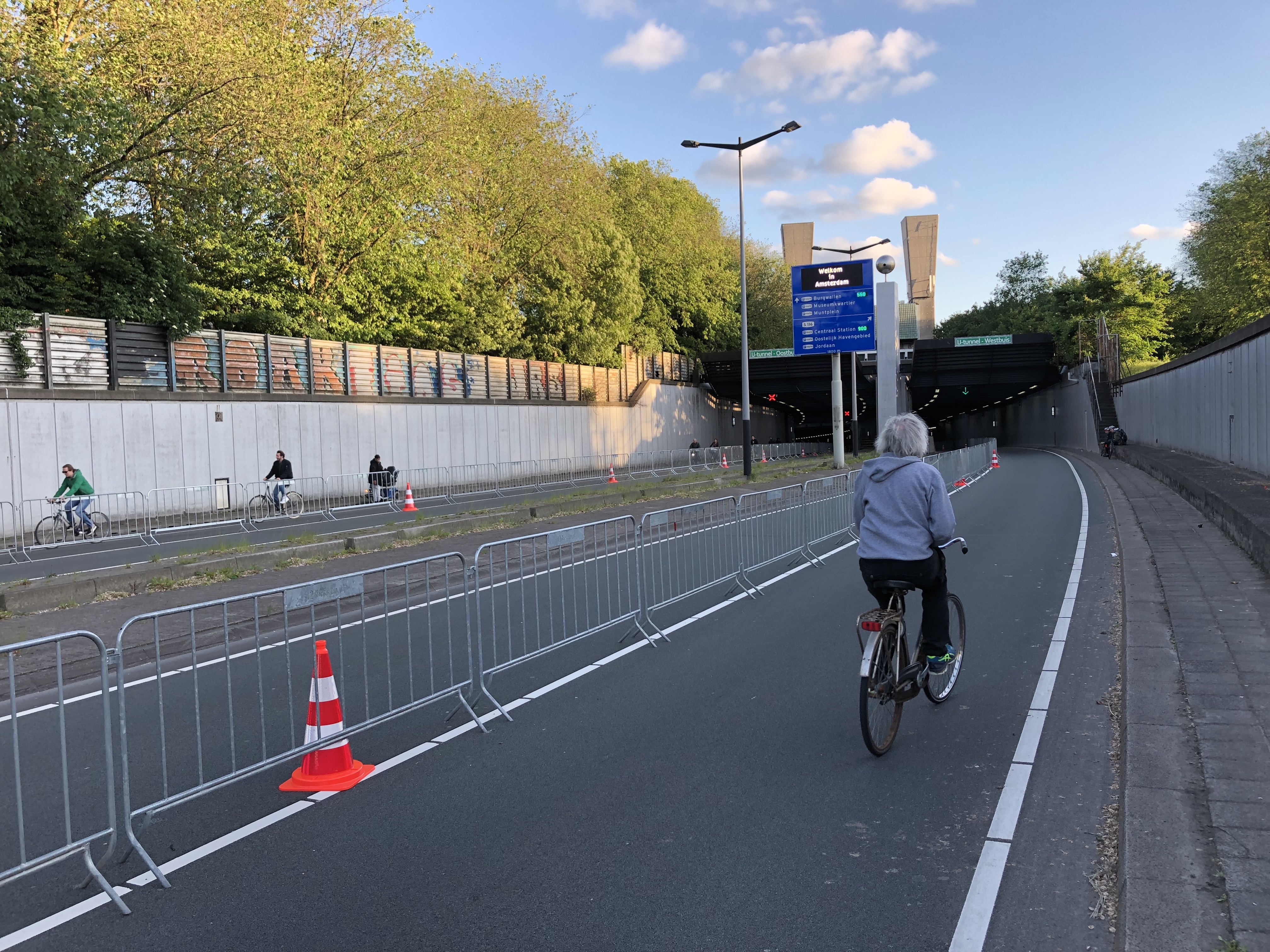
The IJtunnel is rated Class D under the European ADR treaty for the carriage of dangerous goods by road. In practice that means trucks carrying anything that could cause a large explosion, a large toxic release, or a large fire are turned away at the entrance and routed elsewhere. The tunnel is also an entry point to Amsterdam's low-emission zone, and a four-metre height limit keeps the largest trucks out by simple geometry. Pedestrians, cyclists, mopeds and agricultural vehicles are not normally allowed inside. The exception comes when the city's ferries and public transport across the IJ are suspended at the same time, which has happened in 1993, 1997, 2005, and most recently on 28 May 2019 during an industrial strike. On those days the tunnel briefly belongs to bicycles, and the photos that result are among the strangest in Amsterdam's archive.
Once a Year on Foot
Each September the Dam tot Damloop, a road race between Amsterdam and Zaandam, sends its runners through the IJtunnel. For one morning the cars are shut out and tens of thousands of runners pour through the concrete throat in shorts. The sound is unlike anything else the tunnel hears the rest of the year: the breathing of crowded humans amplified by hard surfaces, the slap of running shoes, the cheers of friends echoing off curved walls. The rest of the time the IJtunnel does its quiet job. It carries roughly the same volume of traffic the bridge engineers of the 1950s had projected, plus a generation more, between a city centre that has stayed roughly the same size and a northern district that has grown faster than anyone predicted. It is not glamorous. It is, by the standards of infrastructure, perfect.
From the Air
The southern entrance of the IJtunnel sits at roughly 52.3797°N, 4.9108°E, near the NEMO Science Museum on the eastern edge of central Amsterdam; it surfaces in Amsterdam-Noord across the IJ. From the air, the river and the ventilation buildings are the landmarks. Best viewed at low altitude. Nearest airport is Amsterdam Schiphol (EHAM), about 14 km southwest.