Ino Tadataka
Most people slow down at 49. Ino Tadataka retired. He handed the family sake brewing and rice trading business to his heir in the prosperous town of Sawara, packed a bag, and walked to Edo to enroll as a student of astronomy. He was learning to measure the stars. Five years later, at 55, he petitioned the Tokugawa shogunate to let him survey the entire coastline of Japan. The government said yes but gave him no money. So Ino funded the expedition himself, stepped out of Edo on June 11, 1800, and spent the remaining 17 years of his life walking, measuring, and mapping. By the time his team finished the work three years after his death, they had produced the most accurate maps Japan had ever seen -- maps that would not be surpassed for a century.
From Sake Merchant to Stargazer
Ino was born in 1745 in the small village of Ozeki, on the long sweep of Kujukuri beach in Kazusa Province, what is now Chiba Prefecture. His mother died when he was seven, and his childhood was tumultuous. At 17 he was adopted by the wealthy Ino family of Sawara, a riverside town in Shimosa Province. He proved a capable businessman, expanding the family's sake brewing and rice trading operations until he was one of Sawara's leading citizens. But commerce was not enough. At 49 he retired, moved to Edo, and became the pupil of Takahashi Yoshitoki, a court astronomer. From Takahashi he learned Western astronomy, geography, and mathematics -- the tools that would let him measure not just the night sky but the shape of his country.
Walking the Edge of a Nation
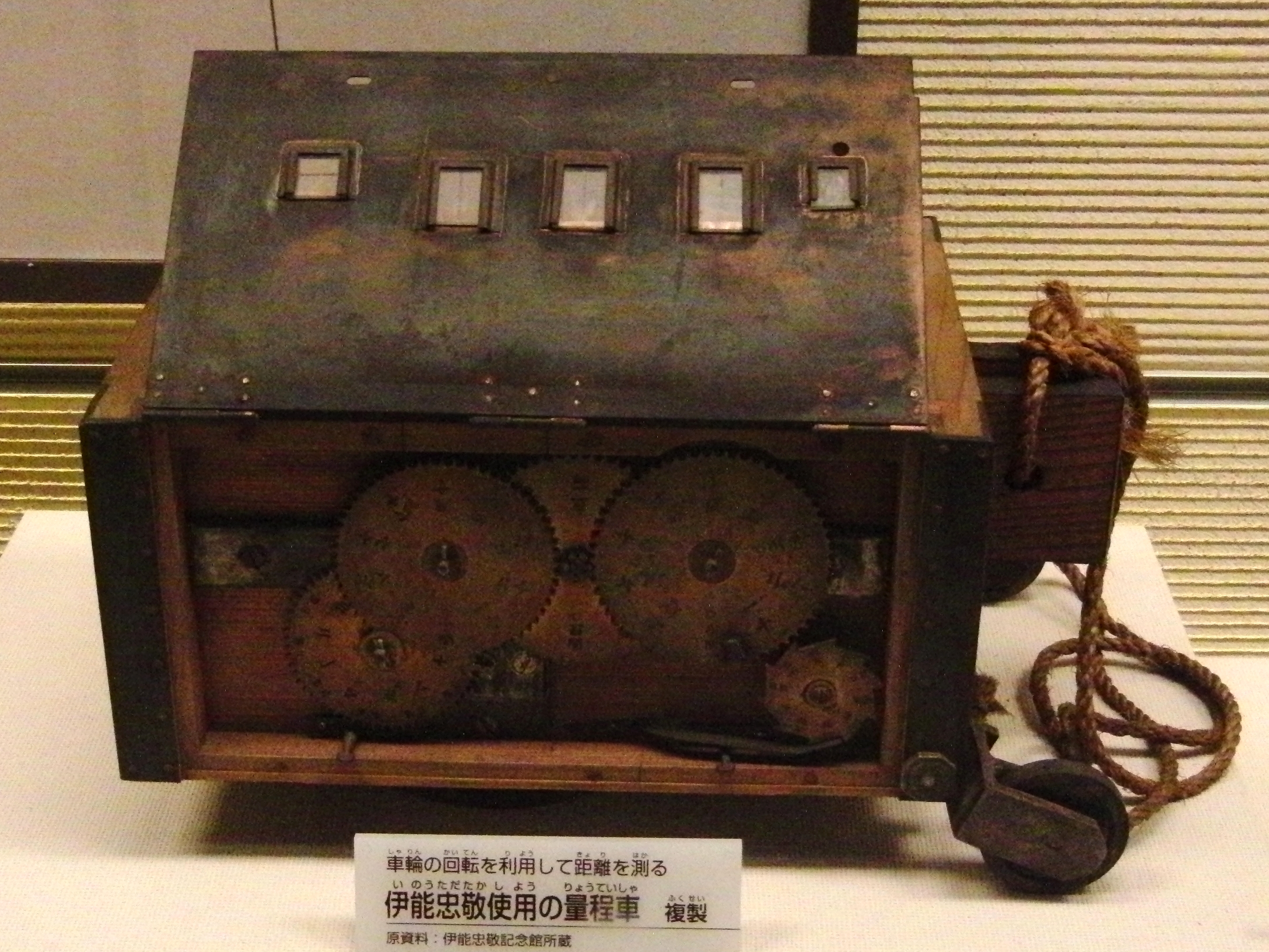
The first expedition left Edo on June 11, 1800 with just five men. Their mission was to chart the coast of Hokkaido, where Russian ships had been appearing at trading posts and the government wanted reliable maps. Ino's method was painstaking: he counted walking steps and took astronomical observations, triangulating positions against the stars. That first survey covered 3,244 kilometers, almost entirely self-funded. The results impressed the shogunate enough that they began providing support for subsequent expeditions. By the fifth expedition, 19 people were involved and they covered nearly 7,000 kilometers. The eighth expedition, mostly through Kyushu, stretched across 13,000 kilometers over 914 days. Ino was 70 years old by then, decades beyond the average lifespan of his era. In total, across ten expeditions, he spent 3,736 days taking measurements and walked 34,913 kilometers -- nearly the circumference of the Earth.
Maps That Outlasted Empires
Ino died in 1818 with his masterwork unfinished. His surveying team completed the final maps in 1821 and published the Dai Nihon Enkai Yochi Zenzu -- "Maps of Japan's Coastal Area" -- an atlas of staggering ambition. It contained three pages of large-scale maps at 1:432,000, the entire country rendered on eight pages at 1:216,000, and 214 pages of coastal detail at 1:36,000. Many of the maps were accurate to one-thousandth of a degree. They remained the definitive maps of Japan for nearly a century, and maps derived from Ino's work were still in official use as late as 1924. Most complete copies of the atlas have been lost to fire and war, but a mostly complete set of the large-scale maps turned up in the U.S. Library of Congress in 2001, a quiet reminder that the work of one retired businessman still circulates through the world's archives.
A Home on the Riverbank
Ino's former residence still stands in Sawara, on the bank of the Ono River in what is now the city of Katori, Chiba Prefecture. The Edo-period complex -- a gate, main building with five rooms, kitchen, library, and kura warehouse, all with tiled roofs -- was designated a National Historic Site in 1930. Ino lived here from his adoption at 17 in 1762 until he left for Edo at 50, though the existing structure dates from 1793 and he occupied it for only two years before departing. Across the river, the Ino Tadataka Museum now tells the full story of his surveys. In 1995, the Japanese government issued a commemorative 80-yen stamp bearing his portrait and a section of his map of Edo. After his death, Ino was enshrined as a kami at the Hokkaido Shrine, one of 37 pioneers honored for their roles in settling and developing Japan's northern frontier -- the same coastline he had walked first.
From the Air
The article's coordinates (35.888N, 140.498E) place this at Sawara in Katori City, Chiba Prefecture, where Ino Tadataka's former residence and memorial museum are located on the Ono River. From altitude, look for the river winding through the historic district of Sawara, a well-preserved Edo-period canal town. The Tone River system and Lake Kasumigaura are prominent nearby water features. Nearest airport: Narita International (RJAA) approximately 12nm west-southwest. The flat agricultural landscape of the Kanto Plain extends in all directions, with the Pacific coast and Kujukuri beach (where Ino was born) visible approximately 25nm to the southeast.