Ingombe Ilede
The graves told the story of who mattered and who did not. At Ingombe Ilede, an archaeological site perched on a hill near the confluence of the Zambezi and Lusitu rivers in southern Zambia, some burials contained glass beads from the Indian Ocean, cowrie shells, gold, copper ingots shaped like crosses, and iron tools so finely crafted they could only have been ceremonial. Other graves held nothing at all. Five centuries ago, this hilltop near the modern town of Siavonga was a trading hub where wealth determined how you were buried and, by extension, how you were remembered.
Where Rivers Meet and Trade Routes Cross
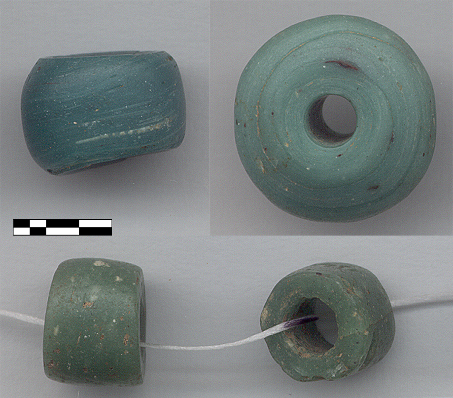
Ingombe Ilede sits where geography invited commerce. The Zambezi River, the great waterway of southeastern Africa, meets the Lusitu at a point that connected the copper-producing regions of the Copperbelt and Katanga to the south with trade routes reaching the Indian Ocean coast. The site's chief commodity was salt, but the goods found in its burials reveal a far wider network. Glass beads analyzed using laser ablation mass spectrometry belong to the Khami series, linking them to the Indian Ocean trade zone and the same commercial networks that sustained Great Zimbabwe and other major sites in the region. Ivory, gold, and enslaved people flowed outward through these routes, while imported cloth, shell beads, and glass moved inland. Ingombe Ilede was not isolated. It was a node in a continental web.
Cross-Shaped Copper
Among the most distinctive artifacts recovered from Ingombe Ilede are copper ingots shaped like crosses. These share their form with ingots from the Copperbelt and Katanga mining areas far to the north, evidence that copper trade among inland sites persisted from at least the 14th century through the 16th. The crosses were not decorative oddities -- they served as a standardized form of currency across Central Africa, much like the Katanga Crosses that traditional families still use symbolically in dowry payments today. Their presence at Ingombe Ilede demonstrates that this hilltop community participated in the same economic system that linked mining regions, river traders, and coastal merchants across thousands of kilometers.
The Buried and the Forgotten
Social stratification at Ingombe Ilede was written in the graves. Archaeologists determined status by burial contents: the affluent, likely traders, were interred with ornaments, beads, ingots, and ceremonial tools. Those without ornaments -- possibly enslaved people or the poorest members of the community -- received bare burials. Iron hoes and axes found in several graves pointed to farming, but researchers distinguished functional tools from ceremonial ones by the wear on their surfaces. Heavily worn hoes told of lives spent in fields; pristine ceremonial axes spoke of authority held. Faunal remains were sparse -- a fragmented ox mandible, bones of wild animals from rats to elephants -- suggesting the community relied more on trade and farming than on livestock. Elephants were hunted for ivory and meat, connecting even the act of eating to the larger commercial network.
Dating the Dead
Pinning down exactly when Ingombe Ilede flourished has challenged archaeologists for decades. Early excavations in the 1960s produced dates suggesting occupation in the 7th or 8th century, but subsequent research by Phillipson and Fagan argued for a domestic occupation near the burials in the 14th and 15th centuries, possibly a second, shorter phase. Their dates did not rule out an earlier first-millennium occupation followed by abandonment and reoccupation. More recent work by McIntosh and Fagan concluded that the occupations involving major social differentiation and long-distance trade are not earlier than the late 15th century, focusing attention on Ingombe Ilede's role in 16th-century trade networks. The site, it appears, reached its commercial peak at roughly the same time Portuguese traders were establishing coastal outposts in Mozambique, reshaping the Indian Ocean trade that had sustained communities like this one for centuries.
A Hilltop Above the Zambezi
The name Ingombe Ilede -- sometimes rendered as Ng'ombe Ilede -- means "sleeping cow" in the local Tonga language, named for a large baobab tree that lies partially on the ground and resembles a resting cow when viewed from a distance. From the hilltop, the Zambezi stretches below, the same river that carried goods and people between the interior and the coast. Today the site lies near Siavonga, a small town on the shores of Lake Kariba. The archaeological remains are not monumental in the way of Great Zimbabwe's stone walls, but they tell an equally important story: that sophisticated trade networks, social hierarchies, and long-distance commercial relationships thrived in southern Zambia centuries before European contact. The glass beads from the Indian Ocean, the copper from the Copperbelt, the gold and ivory headed for distant markets -- all of it converged on this quiet hill above the water.
From the Air
Located at 16.55S, 28.73E near the confluence of the Zambezi and Lusitu rivers in southern Zambia, close to the town of Siavonga on Lake Kariba. The site is on a hilltop visible from low altitude. Nearest major airport: Harry Mwanga Nkumbula International Airport (FLLS, Livingstone, ~200 km SW) or Kenneth Kaunda International Airport (FLKK, Lusaka, ~200 km N). Lake Kariba, one of the world's largest artificial lakes, is a dominant visual landmark. Elevation approximately 500 meters at the site.