Innsbruck
The name is a literal description: a bridge over the Inn. Romans stationed troops here at a crossing they called Oeni Pontum, protecting the Via Claudia Augusta -- the commercial artery linking Verona to Augsburg over the Brenner Pass. The army post they built, Veldidena, survives only as a name on the modern district of Wilten. But the strategic logic that placed soldiers at this narrow point in the Inn Valley -- mountains pressing in from both sides, the river cutting through -- has never stopped mattering. Innsbruck became the capital of Tyrol in 1429 and, by the 1490s, Emperor Maximilian I had moved the imperial court here, transforming a trading town into a center of European politics and culture.
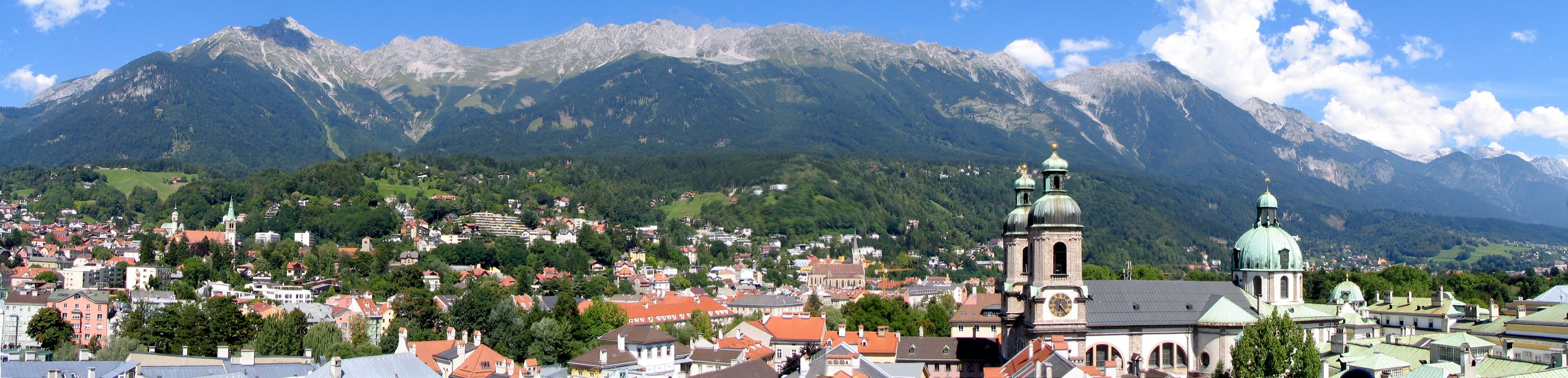
Where Mountains Frame Everything
Innsbruck sits in a valley between peaks exceeding 2,000 meters above sea level, halfway between Bavaria and northern Italy. The Nordkette range rises directly from the city's northern edge -- so close that a funicular, cable car, and chairlift can carry visitors from the historic center to the 2,334-meter summit of Hafelekarspitze without leaving the city limits. To the south, the Patscherkofel offers another aerial perspective. The effect from above is striking: a compact city of around 130,000 people squeezed into a green valley, the Inn River threading silver through its center, with snow-covered ridgelines visible from nearly every street. The continental climate means cold, snowy winters and summers that swing between 30-degree heat and cool rain within the same week.
Two Olympics and a Snowboard Revolution
Innsbruck hosted the Winter Olympic Games in 1964 and 1976, and the infrastructure still shapes daily life. The Bergisel ski jump -- redesigned by architect Zaha Hadid into a sleek, modernist tower -- hosts the annual Four Hills Tournament, one of the moments when Austrians show unrestrained patriotism. The Olympic bobsled run at Igls still operates, offering civilian riders a taste of the track at highway speeds. But it was the snowboard boom of the 1990s that gave the city its current youthful edge. Innsbruck became a hub for snowboard culture, and the subculture endured. The annual Air and Style Snowboard Contest draws over 10,000 spectators and the world's best riders. With over 30,000 university students and easy access to multiple ski resorts via free shuttle buses, the city's winter nightlife pulses with an energy that most Alpine towns can only envy.
The Golden Roof and the Old Town
The heart of historic Innsbruck is compact enough to walk in an afternoon, and nearly every visitor makes the same pilgrimage: down Maria-Theresien-Strasse to the pedestrian zone and the Goldenes Dachl, the Golden Roof. This late-Gothic oriel window, covered in 2,657 fire-gilded copper tiles, was added to the New Residence by Maximilian I in 1500 as a royal box from which to observe tournaments in the square below. Nearby, the Hofburg palace and Hofkirche contain Maximilian's cenotaph, guarded by oversized bronze figures known as the Schwarzen Mandern. The St. Anna Column on Maria-Theresien-Strasse marks a Bavarian invasion repelled on St. Anna's Day in 1703. Darker history lives here too: in this same square in 1536, Jakob Hutter, founder of the Hutterite sect, was burned at the stake.
A City Built for Movement
Innsbruck has become one of Austria's most eco-friendly cities, with six tram lines and a dense bus network threading through the valley. Tram line 6 climbs through upland forests to the mountain village of Igls, offering views back across the city and access to the bathing lake Lansersee. The 18-kilometer STB tram follows the Stubaital valley past autumn larch forests to the town of Fulpmes. Cycling is common -- Innsbruck was named Austria's cycling capital in 2012 -- and the long-distance Inntalradweg bike trail connects Passau to St. Moritz, passing through the city along the Inn River. Even the surrounding geography encourages movement: the Brenner Pass to Italy, the Arlberg tunnel to Vorarlberg, and train connections to Munich, Vienna, Venice, and Zurich make Innsbruck a natural crossroads, just as it was when Roman soldiers guarded that first bridge.
From the Air
Located at 47.268N, 11.393E in the Inn Valley of Tyrol, Austria. The city fills a narrow east-west valley with the Nordkette range (peaks to 2,334 m) immediately north and the Patscherkofel to the south. The Inn River is the primary visual reference, flowing west to east through the city center. Innsbruck Airport (LOWI) is located approximately 2 nm west of the city center, with runway 08/26 aligned along the valley axis. Approach requires careful attention to terrain on both sides. The Brenner Pass corridor is visible to the south-southwest. Best viewed from 4,000-5,000 feet AGL approaching from the west along the valley.