Interstate Park
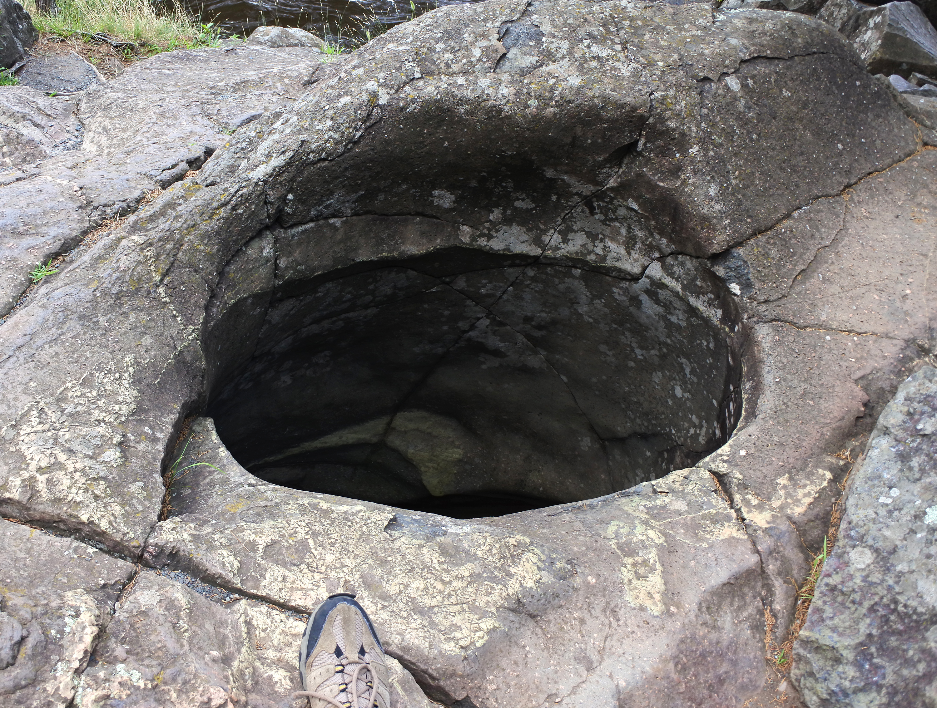
The Bottomless Pit drops sixty feet straight down through solid basalt, twelve to fifteen feet wide, polished smooth by glacial floodwaters that stopped flowing roughly 10,000 years ago. It is the deepest explored pothole in the world, and it sits in a gorge that straddles two states. Interstate Park -- actually two adjacent state parks, one in Minnesota and one in Wisconsin -- protects the Dalles of the St. Croix River, where dark volcanic rock walls rise fifty feet and more above the current waterline. The gorge exposes rocks from three different geological eras spanning over a billion years, making this narrow stretch of river borderland one of the most remarkable open-air geology classrooms in North America.
A Billion Years in Basalt
The oldest rocks at Interstate Park belong to the Keweenawan Supergroup, a thick sequence of volcanic and sedimentary layers that filled a segment of the Midcontinent Rift System roughly 1.1 billion years ago. At least ten separate basaltic lava flows are exposed within the park, remnants of an ancient rift valley that once tore across the continent's interior. Later, during the Cambrian period between 530 and 470 million years ago, a shallow sea deposited sandstone and siltstone atop the basalt. Scientists originally named this epoch the Croixian because the layers exposed here served as its type locality -- the reference standard for the entire geological classification. The most recent chapter belongs to the Cenozoic: as the Laurentide Ice Sheet retreated between 19,000 and 14,000 years ago, glacial Lake Duluth released massive outburst floods down the Brule outlet and into the St. Croix River, carving the deep inner channel known as the Dalles and drilling the park's famous potholes through sheer hydraulic force.
The Travel Agent Who Built Two Parks
Steamboat service to Taylors Falls began in 1838, and by the time a railroad connection arrived in 1880, the Dalles had become a popular tourist destination. A travel agent named George Hazzard saw both a natural wonder and a political opportunity. He launched a campaign to protect both sides of the gorge, rallying newspapers, local landowners, and influential figures like W.H.C. Folsom. The Minnesota Legislature eventually introduced a bill calling for the creation of the State Park of the Dalles of the St. Croix, urging cooperation with Wisconsin. Hazzard and his allies faced stiffer resistance across the river, but in 1900 they succeeded: Wisconsin designated its side as its very first state park. The collaboration made Interstate Park the first parkland in the nation shared between two states -- a boundary-crossing achievement that matched the boundary-crossing geology beneath it.
New Deal Stonework
The 1930s transformed Interstate Park from scenic curiosity into a developed recreation area. U.S. Route 8 was blasted through the Minnesota side in 1931, and the state built stone overlooks and guardrails along the highway. In 1935, Civilian Conservation Corps Company 633 arrived and spent years constructing roads, trails, picnic grounds, a beach and beach house on Lake O' the Dalles, and retaining walls built from local stone. Their work earned recognition as significant examples of National Park Service rustic design. The CCC and WPA Historic District on the Minnesota side preserves six contributing properties, including a 1939 Refectory that now serves as the visitor center, a 1938 retaining wall at the Glacial Gardens, and two rustic restrooms from the 1920s that actually predated and inspired the federal program's design choices.
The Devil's Chair and What Was Lost
Among the park's rock formations, one landmark stood out for generations: the Devil's Chair, a basalt pinnacle on the Minnesota side that resembled a high-backed throne. In April 2005, the formation collapsed. An investigation determined that vandals had used crowbars and possibly a hydraulic spreader to topple the ancient pillar. Despite a reward for information, the culprits were never identified. The loss underscored what makes Interstate Park irreplaceable -- its formations took glacial floods and a billion years of geological time to create, and they cannot be rebuilt. Today, all potholes and sensitive rock areas are off-limits to climbing. Located just an hour's drive from the Minneapolis-Saint Paul metropolitan area, the park draws visitation numbers comparable to many national parks, a level of popularity it has maintained since the 1930s.
From the Air
Located at 45.39°N, 92.67°W along the Minnesota-Wisconsin border. The Dalles of the St. Croix River appears as a narrow, dark-walled gorge cutting through forested terrain, visible from lower altitudes. The St. Croix River is the dominant visual landmark, with the towns of Taylors Falls (MN) and St. Croix Falls (WI) flanking the gorge to the north. Minneapolis-Saint Paul International Airport (KMSP) lies approximately 45 miles to the south-southwest. The park sits within the Saint Croix National Scenic Riverway corridor. Best viewed at 3,000-5,000 feet AGL to appreciate the gorge walls and river channel.