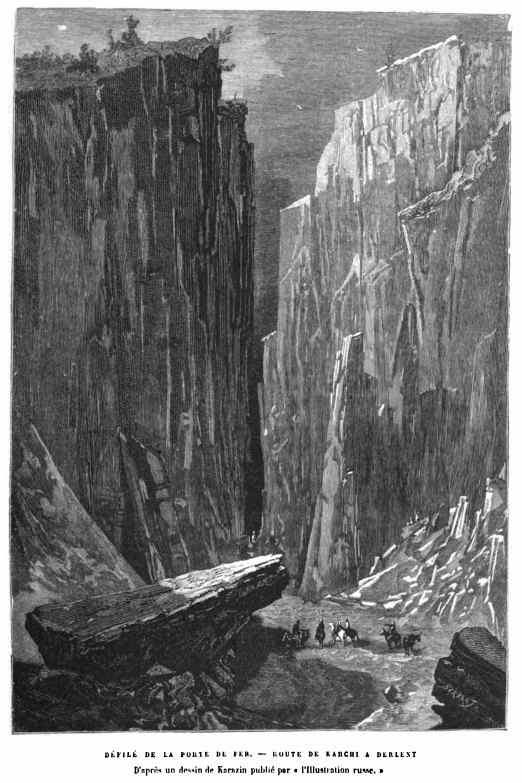
Iron Gate
Somewhere in the mountains west of Boysun, where the Hisar Range drops toward the Amu Darya, there is a gap in the rock. Three kilometers long, narrow enough to bottle an army, it once held -- if you believe the name -- an actual gate reinforced with iron. The Iron Gate, Temir Kapig in the old Turkic inscriptions, was the passage between two worlds: Bactria to the south, Sogdia to the north. Whoever controlled this defile controlled the Silk Road traffic between Balkh and Samarkand, and for centuries, controlling it was worth killing for.
The Hinge Between Civilizations
The defile cuts through a spur of the Hisar Range that runs south toward the Amu Darya, breaking the mountain barrier that otherwise separates the lowlands of modern Afghanistan from the fertile valleys around Samarkand. In ancient times, this was the frontier between Bactria -- the Greek-influenced kingdom that Alexander left behind -- and Sogdia, the Iranian trading culture that dominated Central Asia's commerce. Every army, every merchant caravan, every diplomatic mission moving between these two regions had to pass through the gap. The exact location remains debated among scholars, but it is generally identified as the 3-kilometer pass on the road from Samarkand to Balkh, close to the city of Qarshi. The historian Lev Gumilev recorded its modern name as Buzgala.
Written in Stone
The Iron Gate's strategic importance is literally carved in rock. The Orkhon inscriptions -- stone monuments erected in Mongolia during the 730s -- mention Temir Kapig by name multiple times. These are among the oldest surviving records of the Turkic language, and they treat the defile as a landmark of empire. Kul Tigin's inscription, on its south side, boasts: "In west, I sent an army over the Pearl River to the Iron Gate." Bilge Khagan's inscription describes the founding Turkic ruler Bumin Khagan annexing all territory from the Kadigan forest in the east to the Iron Gate in the west. Tonyukuk, counselor to Bilge Khagan, records reaching the Iron Gate during a campaign in 701 CE. For the medieval Turks of the Goektuerk Empire, the Iron Gate marked the western edge of their world -- the farthest point where their cavalry could project power along the Silk Road.
Chokepoint of Empires
What made the Iron Gate valuable was the same thing that made it dangerous: it was narrow. An army funneled into the pass lost the ability to maneuver, to deploy cavalry on its flanks, to retreat in good order. The defender held every advantage. This geography attracted fortification. The name itself -- Iron Gate, Darband -- suggests a physical barrier, and while no archaeological evidence of a literal iron gate has survived, the concept is entirely plausible. Defiles across Central Asia were routinely fitted with walls and gates throughout antiquity and the medieval period. The pass would have been a natural customs post, a toll gate, a checkpoint where the Silk Road's wealth could be taxed and its travelers scrutinized. Control of the Iron Gate meant revenue as much as security.
The Geography of Power
From the air, the terrain tells the story plainly. The Hisar Range runs roughly east-west, a wall of rock that separates the Kashkadarya River valley from the lowlands of Surxondaryo and the Amu Darya basin beyond. The Iron Gate is the crack in that wall. South of the pass, the land descends toward the ancient cities of Balkh and Termez. North, it opens toward Samarkand, Bukhara, and the great oasis towns of Transoxiana. The defile is not just a mountain pass; it is the geographic logic behind two thousand years of warfare and commerce. Armies that seized it could block invasion. Merchants who passed through it could reach markets separated by hundreds of kilometers of otherwise impassable terrain. The rock itself made the rules, and everyone -- Greek, Turkic, Arab, Mongol -- played by them.
From the Air
The Iron Gate pass is located at approximately 38.22N, 66.91E, west of Boysun in Uzbekistan's Surxondaryo Region. The defile cuts through the Hisar Range and is visible as a narrow gap in the mountain ridge from above. Maintain safe altitude over mountainous terrain -- peaks in the Hisar Range exceed 4,000 meters. Nearest airports: Karshi Airport (UTSL) approximately 70 km northwest, Termez Airport (UTST) approximately 120 km south. Mountain weather can change rapidly; watch for turbulence and reduced visibility.