Iron Range
The locals call it 'da Range,' and the accent is not accidental. Immigrants from over 23 countries -- Finns, Slovenes, Croats, Italians, Swedes, and many more -- poured into northeastern Minnesota between 1880 and 1930, drawn by iron ore wages and the promise of steady work underground and in open pits. They brought their languages, their recipes, and their labor traditions into the boreal forests of the Arrowhead Region, and what emerged was something genuinely unique: a working-class culture built on frozen lakes, red earth, and the understanding that the wealth beneath your feet belongs to everyone who helps bring it to the surface. The Iron Range is not one mine or one town but a constellation of elongated mining districts stretching around Lake Superior, and its story is as much about the people as the ore.
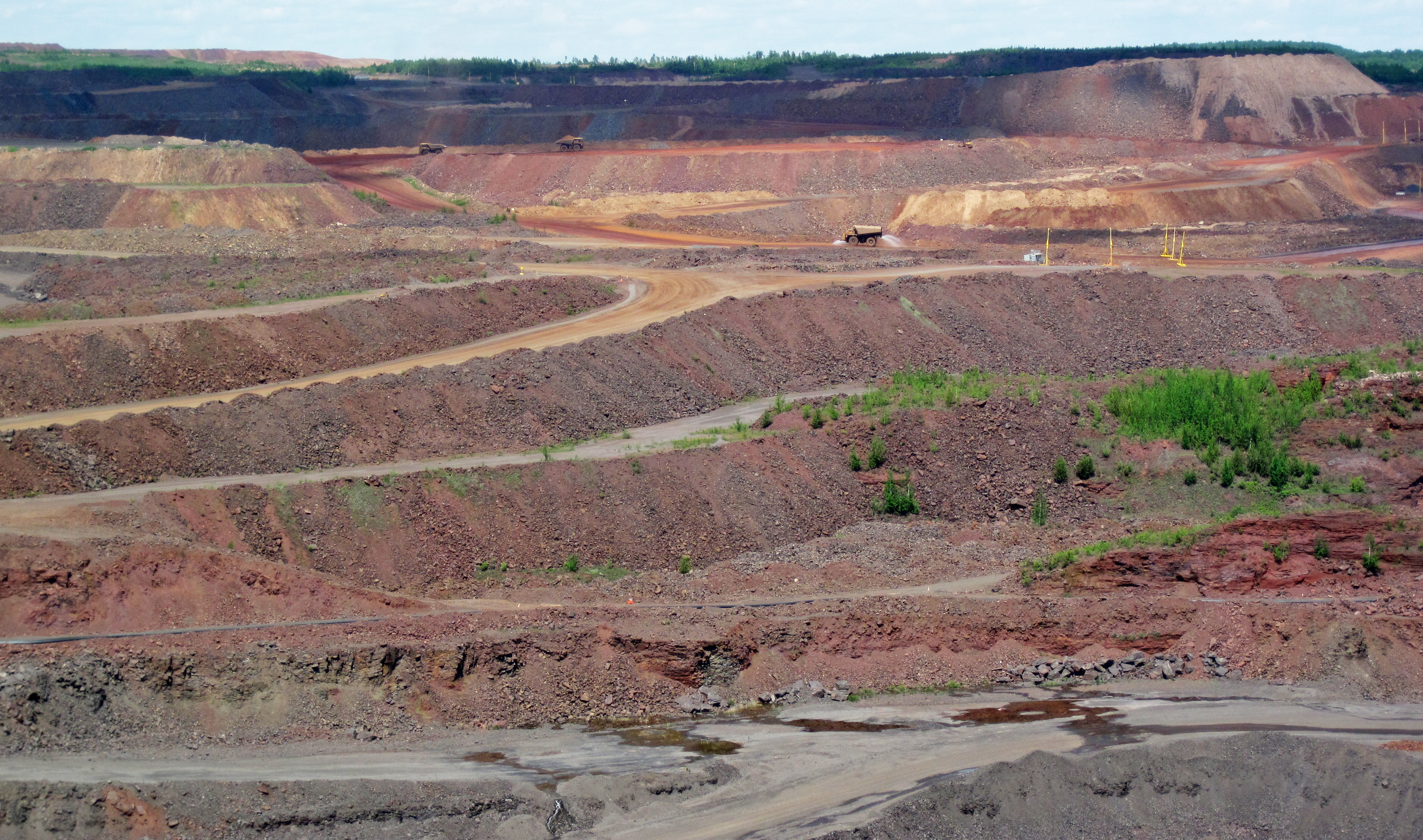
Two Billion Years in the Making
The iron formations of the Range are Precambrian, laid down as banded iron deposits when the planet's atmosphere was still being transformed by photosynthetic cyanobacteria. Minnesota's Iron Range encompasses four major deposits: the Mesabi Range, the largest, spanning Itasca and Saint Louis counties; the Vermilion Range to its northeast; the Gunflint Range in the extreme northern portion of Cook County, extending into Canada; and the Cuyuna Range to the southwest in Crow Wing County. William Austin Burt first discovered iron ore in the Marquette Range near Negaunee, Michigan, in 1844. Minnesota's own deposits followed: the Vermilion Range in 1885, the Mesabi in 1890, and the Cuyuna in 1903. Natural ores fueled production from 1848 until the mid-1950s, when the industry shifted to processing taconite -- a lower-grade rock that could be concentrated and pelletized into usable iron.
Twenty-Three Flags, One Range
By 1910, the Finns had become the largest immigrant group on the Range, followed by Slovenes and Croats from the Austrian Empire, then Italians and Swedes. These communities did not melt so much as layer, each adding distinctive flavors to the regional identity. The Iron Range cuisine tells the story: Cornish pasties -- beef, rutabaga, onion, carrots, and potatoes wrapped in pastry -- became the standard miner's lunch, practical enough to eat deep underground without utensils. Slovenian and Croatian immigrants introduced potica, a honey-nut bread still served at Easter and Christmas tables across northern Minnesota. Over time, the blended population developed its own accent, its own humor, and its own fierce sense of place. The nickname 'Ranger' carries real pride.
Ice, Sticks, and a Miracle
Hockey is the predominant sport on the Range, and the tradition runs deeper than recreation. The region has produced numerous NHL players, but its proudest moment came in February 1980 at the Winter Olympics in Lake Placid, New York. Three members of the U.S. men's hockey team that defeated the heavily favored Soviet Union in the 'Miracle on Ice' game came from the Iron Range. That upset -- a group of college kids beating a squad widely considered the best hockey team in the world -- resonated powerfully in a region that has always identified with underdog grit. The U.S. Hockey Hall of Fame sits in Eveleth, right on the Range. In 2022, the documentary Hockeyland captured the intensity of high school hockey in the Iron Range and Duluth area, a reminder that the sport remains central to community life here.
Dylan's North Country Blues
Bob Dylan grew up in Hibbing, the Range's largest city, and the landscape marked him permanently. His 1963 song 'North Country Blues,' from the album The Times They Are a-Changin', is a first-person lament from a miner's wife watching her community hollow out as the mines close. 'So the mining gates locked and the red iron rotted / And the room smelled heavy from drinking / When the sad, silent song made the hour twice as long / As I waited for the sun to go sinking.' The song captured a real anxiety. Mining employment has fluctuated dramatically over the decades, and the Range has weathered multiple boom-and-bust cycles. Today, the region's outdoor recreation opportunities and relative remoteness attract new residents unconnected to mining, but tensions persist between those who see the industry as the Range's lifeblood and environmentalists concerned about proposals to mine copper and nickel near protected lands like the Boundary Waters.
Forty Below and Counting
The Iron Range earns its reputation for harsh winters. The average year-round temperature in Virginia, Minnesota, is just 38 degrees Fahrenheit. January lows average minus 6 Fahrenheit, and temperatures below minus 40 -- the point where Fahrenheit and Celsius converge -- occur somewhere in the region during most winters. Snowfall averages over 53 inches annually. The ore ships that once carried iron to the steel mills of Pittsburgh and Gary via Duluth and Two Harbors had to shut down when Lake Superior froze. The mines themselves operated year-round, their exposed faces turning into frozen walls of red-stained ice. The people who chose to settle here did not come for the weather. They came for the work, and they stayed because the place they built together -- this improbable patchwork of cultures welded by cold and common purpose -- became home.
From the Air
The Iron Range spans a broad area of northeastern Minnesota's Arrowhead Region, centered approximately at 47.45°N, 92.93°W. From altitude, the mining districts are unmistakable: enormous red-orange terraced pits and water-filled former mines punctuate the otherwise dense boreal forest. The Mesabi Range runs roughly east-west through towns including Hibbing, Virginia, Eveleth, and Chisholm. Range Regional Airport (KHIB) serves Hibbing; Duluth International Airport (KDLH) is the major commercial field approximately 75 nautical miles southeast. At 8,000-12,000 feet, the full scale of the mining landscape becomes apparent -- dozens of active and abandoned pits, tailings basins, and ore processing facilities stretching across the horizon. Lake Superior is visible to the east on clear days. Winters bring extensive ice and snow cover; summer reveals the vivid contrast between green forest and red exposed earth.