Isla Suarez
Two countries claim this island and neither seems to want it badly enough to fight. Isla Suarez -- or Ilha de Guajara-Mirim, depending on which side of the Mamore River you ask -- has been the subject of diplomatic notes, treaties, and studied inaction since 1867. The island sits in the wide, brown current of the Mamore, which forms the border between Bolivia's Beni department and Brazil's Rondonia state, and its sovereignty remains unresolved in a way that says more about the nature of borders in the Amazon than any map could.
A Line Drawn on Water
The trouble began with the Treaty of Ayacucho, signed on March 27, 1867, which attempted to draw a line between Brazil and Bolivia through some of the most remote terrain on the continent. Article 2 of the treaty sent the border down the Verde River to the Guapore and along the Mamore to the Beni, where the Madeira River begins. A commission demarcated the boundary in 1877, but rivers are unreliable borders. They shift course, deposit sandbars, carve new channels. An island in the middle of a river presents a particular problem: which bank is it closer to? Which nation's current wraps around it more possessively? In 1896, the Bolivian company Irmaos Suarez established operations on the island, and their name stuck to the Bolivian side of the argument. The Treaty of Petropolis in 1903 confirmed the original boundary without resolving the island question.
Complaints, Reports, and Studied Inaction
The diplomatic file on Isla Suarez reads like a slow-motion negotiation between two parties who would rather not negotiate at all. In 1930, the Brazilian legation in La Paz lodged a formal complaint about what it considered Bolivia's inadequate occupation of the island. Bolivia responded in 1937 with a report demonstrating the island's greater proximity to the Bolivian bank -- a claim Brazil rejected. In 1955, Brazil announced plans to establish a police post on the island, then quietly abandoned the project. The pattern suggests something more interesting than a territorial dispute: it suggests two nations performing sovereignty without fully committing to it. The Robore Agreement of 1958 acknowledged the stalemate explicitly, promising that the two governments would, at some unspecified future date, re-examine the legal status of the island. The Brazilian Congress ratified this agreement ten years later, in 1968, and the re-examination has yet to begin.
The Island Between
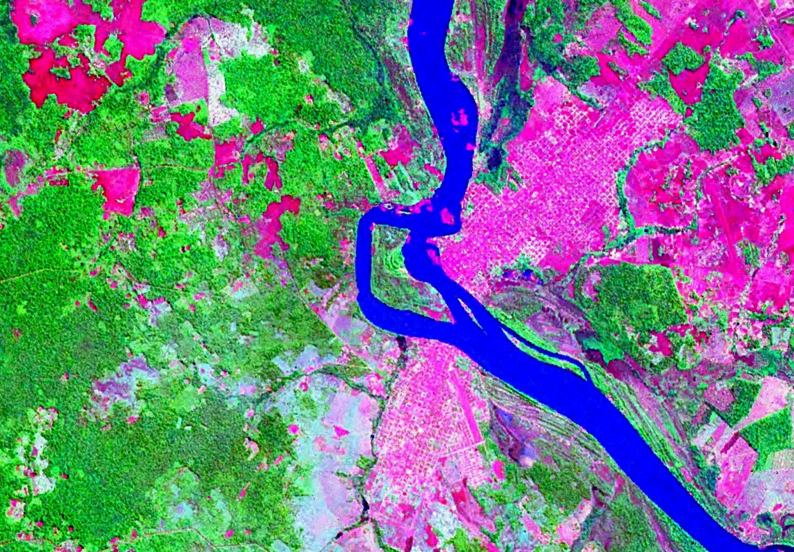
On the ground -- or rather, on the water -- the situation is simpler than the diplomats have made it. Brazilian inhabitants of the nearby city of Guajara-Mirim use the island for economic activity and hold most of its territory in practical terms. Bolivia administers it de jure. The island sits in the Mamore, which runs wide and silty through flat Amazonian terrain, its banks lined with dense forest that drops straight to the waterline. From the air, the island appears as a green oval in a river that loops and oxbows across the landscape in the extravagant meanders typical of lowland Amazonian waterways. It is one piece of a much larger puzzle: more than 80 islands in the Guapore and Mamore rivers remain unassigned to either country, each one a minor territorial question that has never quite mattered enough to resolve.
Sovereignty as Suggestion
What makes Isla Suarez compelling is not the island itself but what it reveals about the nature of sovereignty in places where the state is thin. In the capitals of Brasilia and La Paz, borders are lines on official maps, subjects of treaties and ratifications. In the western Amazon, borders are rivers that flood their banks for months each year, turning everything into water and making the question of which side you stand on genuinely difficult to answer. The Mamore does not care about the Treaty of Ayacucho. It carves its own path, depositing silt here, eroding a bank there, occasionally stranding a piece of one nation's territory on the other's side. Isla Suarez endures as a reminder that some questions persist not because they are hard to solve but because solving them matters less than the rhythm of daily life on the river.
From the Air
Located at 10.80S, 65.36W in the Mamore River, which forms the international boundary between Bolivia (Beni department) and Brazil (Rondonia state). The island is visible as a distinct green landmass in the wide, meandering river. The nearby city of Guajara-Mirim, Brazil, sits on the eastern bank, with Guayaramerin, Bolivia, across the river. Nearest airports: Guajara-Mirim Airport (SBGM) on the Brazilian side and Guayaramerin Airport (SLGM) on the Bolivian side. Best viewed at 3,000-8,000 feet AGL to appreciate the river's meanders and the island's position between the two countries. The Mamore's extensive oxbow lakes and shifting channels are visible across the floodplain.