Islas Marietas National Park
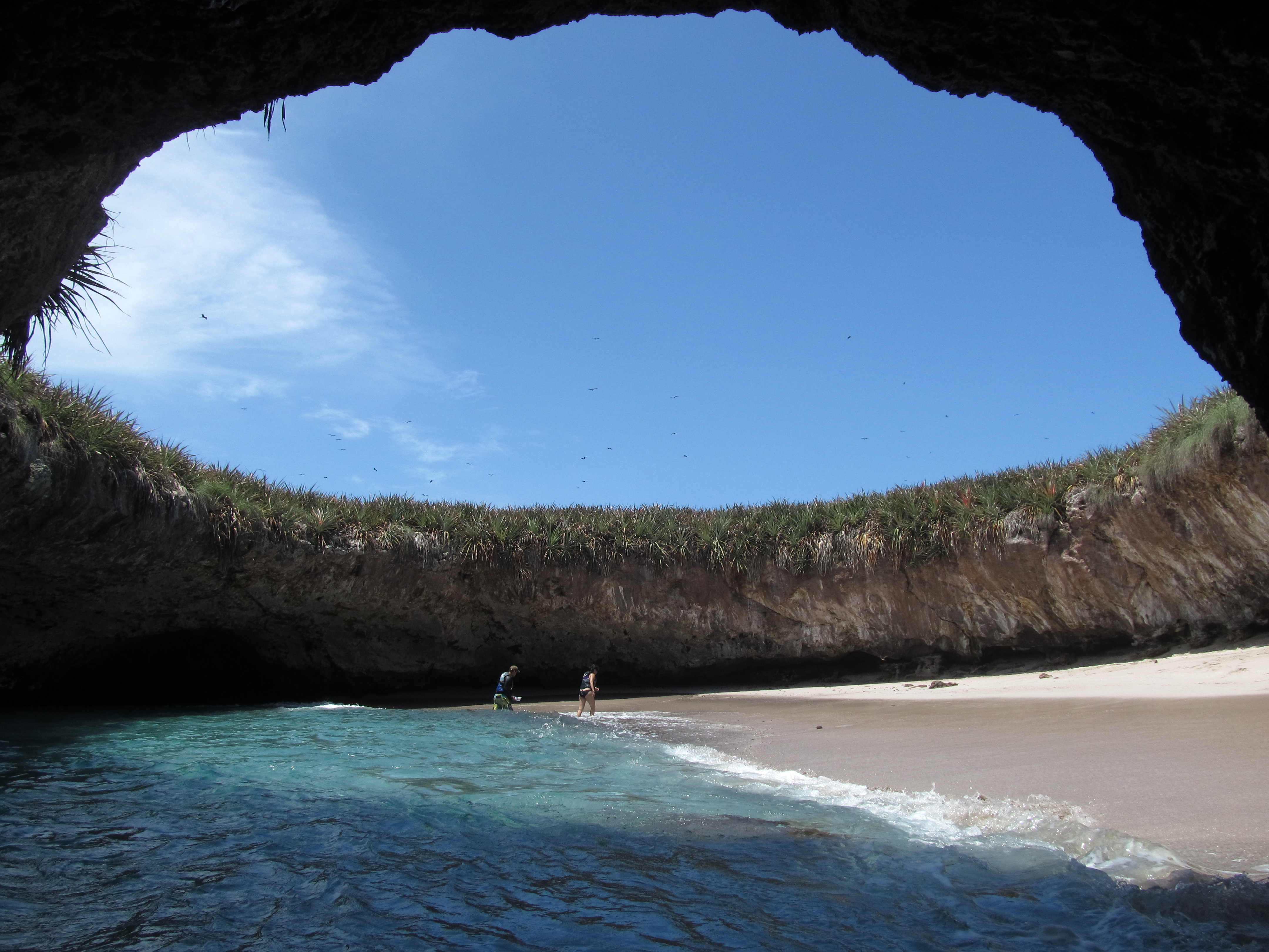
The beach has no road, no dock, no path. To reach the Playa del Amor on the Marieta Islands, you swim through a short tunnel carved by the Pacific into volcanic rock, then surface inside a collapsed crater open to the sky. Sand rings the interior. Waves lap gently. The effect is of stumbling into a private world, a pocket of coast hidden inside the island itself. When photos of this hidden beach went viral around 2015, tourist numbers exploded from 27,500 visitors a year to more than 127,000. By 2016, boats were dropping 2,500 people a day onto an island the University of Guadalajara determined could sustain 116 without degradation. The Marieta Islands became a case study in what happens when a fragile place becomes famous overnight.
A Volcanic Architecture
The Marieta Islands sit approximately 7.9 kilometers southwest of Punta de Mita, in federal waters off the coast of Nayarit. They are volcanic in origin, built from two types of rock: a softer interior of explosive volcanic material that erodes quickly, and a harder exterior shell that resists the Pacific's assault. This layered geology explains the islands' most dramatic features. The hidden beach is essentially a hole where the soft interior collapsed while the outer ring held firm, creating a roofless cavern with a sandy floor. Studies from 2014 estimate the islands have a few thousand years of structural life remaining, though human activity is accelerating the erosion. The ocean depth around the islands ranges between 70 and 110 feet, enough to support the coral reefs and cave systems that make the underwater landscape as complex as the surface.
Boobies, Whales, and the Underwater City
Protected from fishing and hunting by the Mexican government, the Marietas have become a wildlife refuge that punches far above their modest size. Blue-footed boobies breed on the rocky outcrops, their vivid turquoise feet unmistakable against the gray stone. Red-billed tropicbirds nest alongside them. Below the waterline, coral gardens shelter manta rays, sea turtles, eels, and reef fish in kaleidoscopic density. Dolphins patrol the deeper channels. Each winter, from December through March, humpback whales migrate from Alaska to give birth in the warm waters off Nayarit, passing close enough to the islands that whale-watching boats routinely encounter them alongside octopus and sea turtles. The islands are a designated Ramsar wetland site and fall within a UNESCO biosphere reserve, recognition that this small archipelago supports an ecosystem of disproportionate richness.
When the World Found Out
The crisis arrived through smartphones. As images of the hidden beach circulated on social media, tourist demand overwhelmed every limit. During Easter holidays in 2016, more than 250 boats landed on the island per day, some carrying as many as 400 tourists. Anchors dropped up to 250 times daily onto coral reefs. Hydrocarbon pollution from boat engines fouled the water. Solid waste accumulated. The coral, already stressed by warming ocean temperatures, began dying under the combined assault. Even the humpback whales showed signs of disturbance from hydrocarbon contamination. In April 2016, Mexican authorities closed the islands to the public entirely. Rumors spread on social media that the islands had been sold to foreign corporations, prompting the governor of Nayarit, Roberto Sandoval, to publicly declare them part of Mexico's national heritage, permanently.
Coral Grafts and Floating Docks
The recovery effort led by Mexico's National Commission of Natural Protected Areas, CONANP, has centered on two fronts: repairing what tourism damaged and preventing it from happening again. Marine biologists have been grafting new coral onto surviving reef structures, a painstaking process that requires three to four months of growth before the grafts take hold. For future access, CONANP has proposed installing floating docks in the bay to control the number and size of vessels, replacing the chaotic free-for-all that allowed hundreds of boats to crowd the islands simultaneously. Buoy systems around fragile zones would channel visitors away from the most vulnerable reef areas. The Mexican government now permits only a limited number of licensed operators to bring visitors, and landing on the hidden beach requires a specific permit from SEMARNAT, Mexico's environmental ministry. The carrying capacity of the entire park has been set at 625 visitors per day, a number that reflects both ecological science and the hard lesson of what uncontrolled access cost.
The View from Above
From the air, the Marieta Islands appear as dark volcanic shapes set in water that shifts from deep Pacific blue to the luminous turquoise of shallow reef zones. The hidden beach is not visible from altitude; its magic depends on being enclosed. What is visible is the isolation, the distance from the mainland, the smallness of the islands against the vast bay. Nayarit's coast stretches south toward Puerto Vallarta, the Sierra Madre Occidental rising behind it. The islands look like what they are: fragments of an older volcanic landscape, fragile and finite, holding on against the ocean that made them and the attention that nearly unmade them.
From the Air
Located at 20.699°N, 105.585°W, approximately 7.9 km southwest of Punta de Mita. The islands are small volcanic formations visible in Banderas Bay. From 3,000-5,000 feet, the shallow reef areas create turquoise water contrast against the deep blue Pacific. Nearest major airport is Puerto Vallarta (MMPR/PVR). The coast of Nayarit and the Sierra Madre Occidental provide visual orientation. Best viewed in morning light when water clarity reveals reef structures.