Iximche
The country of Guatemala takes its name from a place most Guatemalans have never visited. When Spanish conquistadors founded their first capital at the Kaqchikel Maya city of Iximche in 1524, their Nahuatl-speaking Mexican allies called it Quauhtemallan - 'forested land.' The Spanish adopted the name, applied it to their new colony, and eventually to the entire nation. Meanwhile the city itself was abandoned within three years, left to the highland pine forests and the deep ravines that had made it defensible in the first place. Today Iximche sits 3 kilometers south of Tecpan, 90 kilometers west of the capital that inherited its name, a quiet archaeological site where pyramid-temples and ballcourts rise from manicured grass at 2,260 meters above sea level. The Kaqchikel Maya still come here to perform ceremonies. The name Iximche derives from the Mayan word for the ramon tree - ixim che, literally 'maize tree' - and on weekends roughly 250 visitors walk among the ruins of a city that once rivaled any in the Guatemalan Highlands.
A Kingdom on a Ridge
The Kaqchikel founded Iximche around 1470, fleeing their former overlords the K'iche' Maya after growing friction within the alliance became untenable. They chose their location shrewdly: a promontory called Ratzamut, almost entirely surrounded by deep ravines that served as natural fortifications. Four principal lords from the four main clans - the Sotz'il, the Xahil, the Tukuche, and the Akajal - ruled the city, though real power rested with the lords of the Sotz'il and Xahil. Each lord maintained his own palace, royal court, and temples within separate sectors of the city. Within 50 years of its founding, Iximche had reached its maximum extent, becoming the second most important city in the Guatemalan Highlands after the K'iche' capital at Q'umarkaj. By 1491, the Kaqchikel had turned the tables on their former masters entirely, capturing and sacrificing the K'iche' kings along with their most important religious idol.
Conquistadors as Guests, Then Masters
When word reached Iximche that Hernan Cortes had defeated the Aztecs, the Kaqchikel kings made a calculated gamble: they sent messengers offering an alliance with the Spanish. Conquistador Pedro de Alvarado arrived in 1524 and was received warmly. The Kaqchikel provided soldiers to help defeat their neighboring rivals, the K'iche' and the Tz'utuhil. It seemed like a partnership of convenience. Then Alvarado revealed the cost of Spanish friendship. On July 27, 1524, he declared Iximche the first capital of Guatemala - Santiago de los Caballeros de Guatemala - and demanded that the Kaqchikel kings deliver 1,000 gold leaves, each worth 15 pesos. The alliance fractured. The Kaqchikel abandoned their city and launched a guerrilla resistance that lasted years. The Spanish relocated their capital in 1527, driven out by continuous attacks. It was not until May 9, 1530, that the two most important Kaqchikel kings finally surrendered.
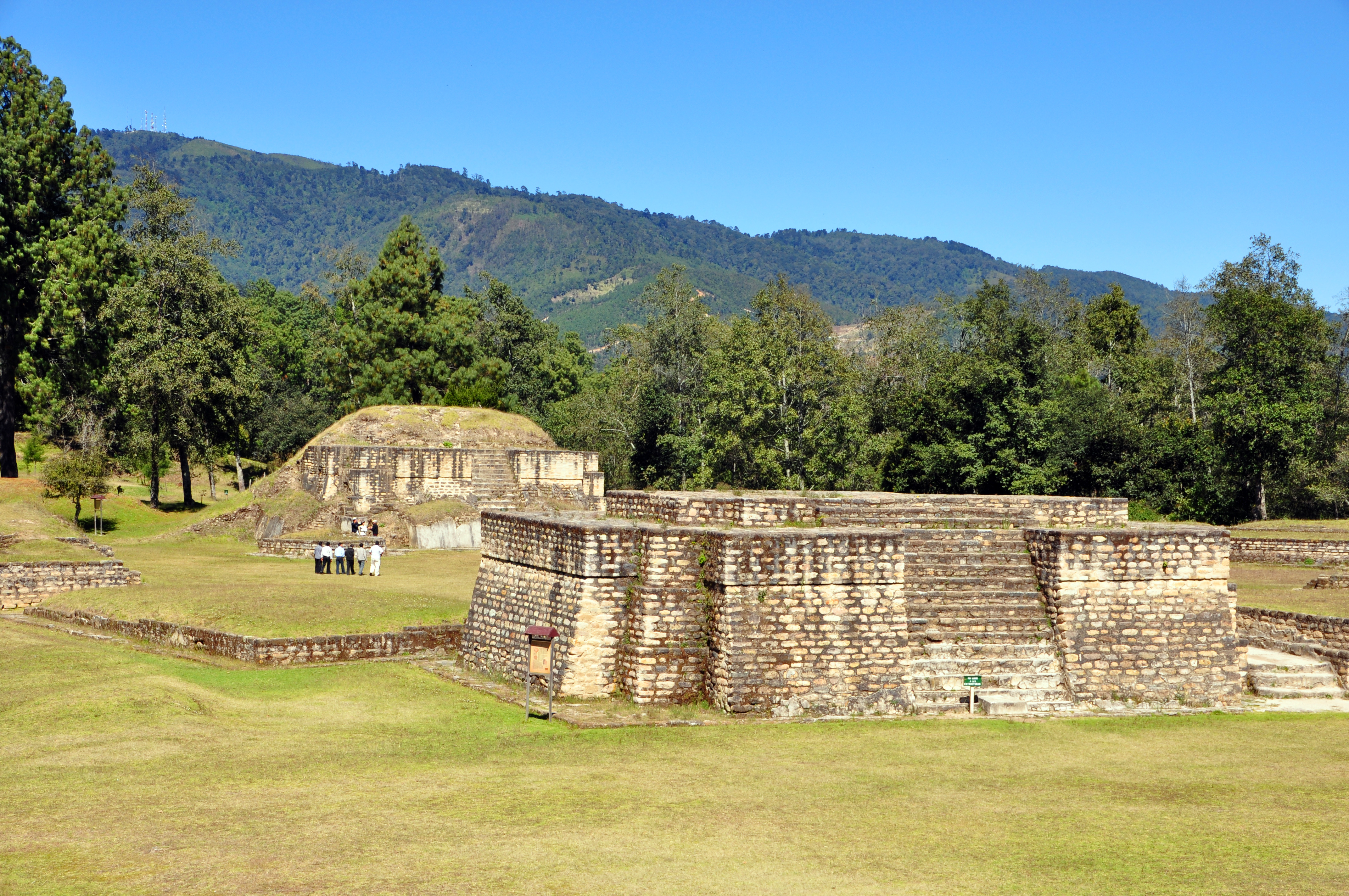
Temples, Ballcourts, and Evidence of Sacrifice
The ruins at Iximche reveal a city organized around ceremonial plazas. Plaza A and Plaza B held the major pyramid-temples of the Sotz'il clan, while Plaza C served the Xahil. Temple 2, a tiered pyramidal platform on Plaza A's west side, rises 9 meters above the plaza floor; at the top of its steep stairway sits a sacrificial altar measuring just 45 centimeters wide. Archaeologists found two decapitated skulls cached nearby alongside obsidian blades. Across the site, 36 skulls were analyzed - 25 showed evidence of decapitation. Most of the sacrificed individuals were young adults. Two ballcourts hosted the Mesoamerican ball game, with one dating to approximately 1500 AD. The structures were faced in lime-plastered stone blocks, some painted with Mixtec-Puebla style murals that originated in central Mexico around 900 AD. Adobe superstructures and beam-and-mortar roofs have long since vanished. Because the Spanish occupation was brief, almost no European artifacts were found - only a few forged iron crossbow bolts.
Sacred Ground, Still Living
Iximche never entirely lost its significance to the Kaqchikel people. In 1980, during the Guatemalan Civil War, guerrilla leaders and Maya elders met at the ruins to discuss indigenous rights. A ceremony in 1989 formally reestablished the site as sacred ground for Maya rituals. When U.S. President George W. Bush visited in 2007, Maya priests performed a purification ritual afterward. That same year, Iximche hosted the III Continental Summit of Indigenous Peoples and Nationalities of Abya Yala. The site was first described by a Guatemalan historian in the late 17th century and excavated systematically by Swiss-Guatemalan archaeologist George Guillemin from 1959 to 1972. American diplomat John Lloyd Stephens visited in 1840 with artist Frederick Catherwood, noting that locals had been quarrying the site's stone for building materials in nearby Tecpan. Today a small museum displays sculptures and ceramics recovered from the excavations. The ruins are open daily - a place where archaeology, politics, and living spiritual practice occupy the same ground.
From the Air
Located at 14.74°N, 91.00°W in Guatemala's western highlands at 2,260m elevation. The site sits on a ridge (Ratzamut promontory) 3km south of Tecpan Guatemala, visible as a cleared area among pine forests with geometric ruins. Approximately 90km west of Guatemala City. La Aurora International Airport (MGGT) lies to the east. The dramatic highland terrain features deep ravines surrounding the ridge on which the ruins sit.