Izalco (volcano)
For nearly two centuries, sailors navigating the Pacific coast of Central America could set their course by a glow on the horizon. Izalco volcano, perched on the southern flank of the older Santa Ana Volcano in western El Salvador, erupted so persistently from the year of its birth in 1770 until 1958 that mariners nicknamed it the "Lighthouse of the Pacific." The light was not subtle. Lava fountains, incandescent rockfalls, and ash plumes lit up the night sky with a regularity that made the volcano more dependable than most actual lighthouses. Then, after 188 years of nearly continuous activity, Izalco went quiet. It has not erupted since a flank event in 1966.
A Volcano Born from Another
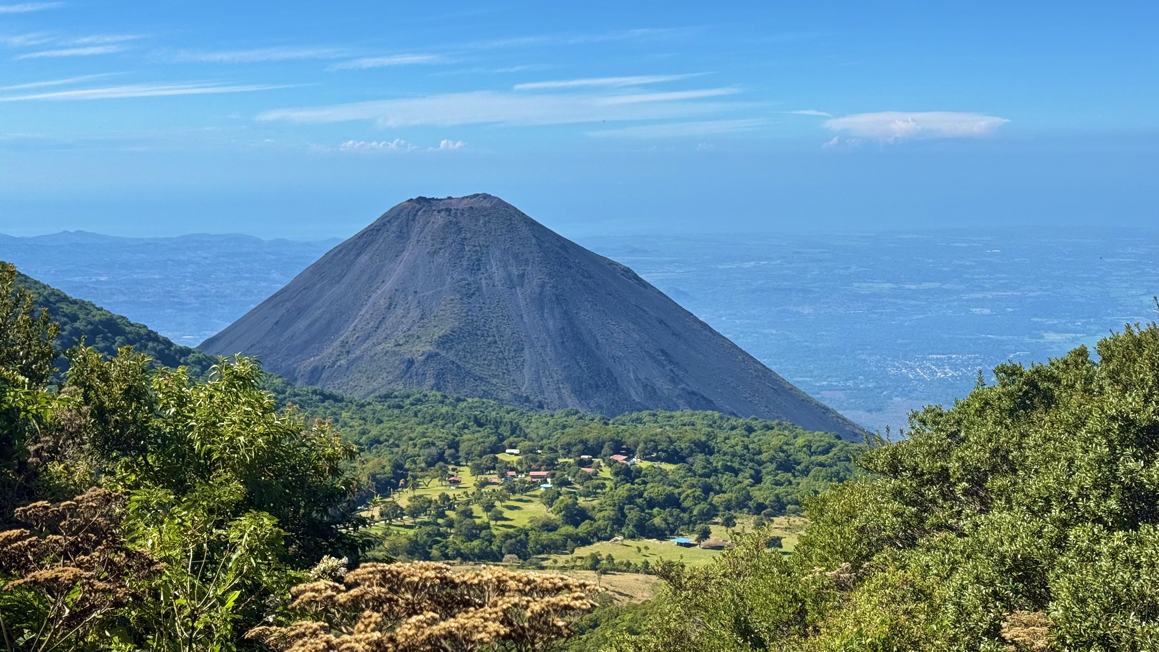
Izalco did not exist before 1770. Fumarolic activity -- steam and gas venting through cracks in the earth -- had been recorded on the southern slopes of Santa Ana Volcano as early as 1658, but for over a century nothing more dramatic occurred. Then a new vent opened, and a cone began to grow. Over the following two hundred years, eruption after eruption piled lava and tephra into a steep, symmetrical stratovolcano that eventually rose approximately 1,830 meters above sea level, gaining about 650 meters of height above its original vent. The cone remains strikingly bare -- its black slopes largely devoid of vegetation, a stark contrast to the green flanks of neighboring Santa Ana. More than 50 eruptions have been recorded since the volcano's birth, making Izalco one of the most active volcanoes in Central America during its active period.
The Night the Village Disappeared
Izalco's eruptions were not always a distant spectacle. The volcano sits on highly arable land that was cultivated for coffee, cacao, and sugar cane, and communities lived close to its slopes. In 1926, an eruption buried the village of Matazano and killed 56 people. The disaster underscored a tension that runs through volcanic regions worldwide: the same geological forces that make soil rich and harvests abundant also make the ground unpredictable. Farmers returned after each eruption because the land was too productive to abandon. The lava that Izalco produced -- vesicular, olivine-rich basalt -- weathered into fertile soil, feeding the coffee plantations that became central to El Salvador's economy. Risk and reward grew from the same source.
A Mineral Cabinet in the Fumaroles
When the eruptions ceased, Izalco did not become geologically inert. Rainwater still seeps through the porous rock, contacts hot subsurface material, and vents as steam through fumaroles near the summit. These fumarole deposits have made the volcano a site of unusual mineralogical significance. Izalco is the type locality -- the place where a mineral was first scientifically described -- for eight rare copper-vanadium minerals: bannermanite, blossite, fingerite, howardevansite, lyonsite, mcbirneyite, stoiberite, and ziesite. Most of these minerals are found in almost no other location on Earth. The volcano that once served as a navigational beacon now serves as a natural laboratory, its chemical exhaust producing crystals that exist at the intersection of extreme heat, copper, and vanadium.
Symbol on the Skyline
Izalco has been woven into Salvadoran national identity since long before it fell silent. The volcano appeared on the country's coat of arms, and its image graced some of El Salvador's earliest postage stamps in the 1860s -- covers genuinely used with those stamps are now extreme rarities, with only 37 recorded. Today, Izalco is part of the Cerro Verde National Park complex, which also includes the Santa Ana Volcano and Cerro Verde itself. Hikers climb the bare black cone for views that stretch to the Pacific, and the volcano's perfect symmetry makes it one of the most photographed landmarks in the country. Whether it will erupt again is not a question of if but when. The geological forces that built Izalco in two centuries have not disappeared; they are merely resting.
From the Air
Located at 13.81N, 89.63W on the southern flank of Santa Ana Volcano in western El Salvador, rising to approximately 1,830 meters (6,004 feet). From altitude, Izalco is immediately recognizable as a near-perfect dark cone with minimal vegetation, contrasting sharply with the green slopes of the larger Santa Ana Volcano to its north. The volcano is part of the Cerro Verde National Park complex. Nearest major airport is El Salvador International (MSLP), approximately 60 km to the southeast. The Pacific coast is visible to the south. Maintain safe altitude and be aware of potential fumarolic activity and mountain weather conditions. The Coatepeque caldera lake is a prominent landmark nearby to the east.