Izu Oshima
Technically, this is Tokyo. Not the neon canyons of Shinjuku or the crossing at Shibuya, but a 91-square-kilometer volcanic island floating in the Philippine Sea, two hours by high-speed ferry from the capital's Takeshiba Pier. Izu Oshima is the largest and nearest of Tokyo's outlying islands, a place where the city's administrative reach extends to a landscape that feels nothing like the metropolis -- black lava fields, dense camellia forests, and the brooding cone of Mount Mihara rising 758 meters above the Pacific. The island has been part of the Fuji-Hakone-Izu National Park since its designation, sharing protected status with Mount Fuji itself.
Born from the Deep
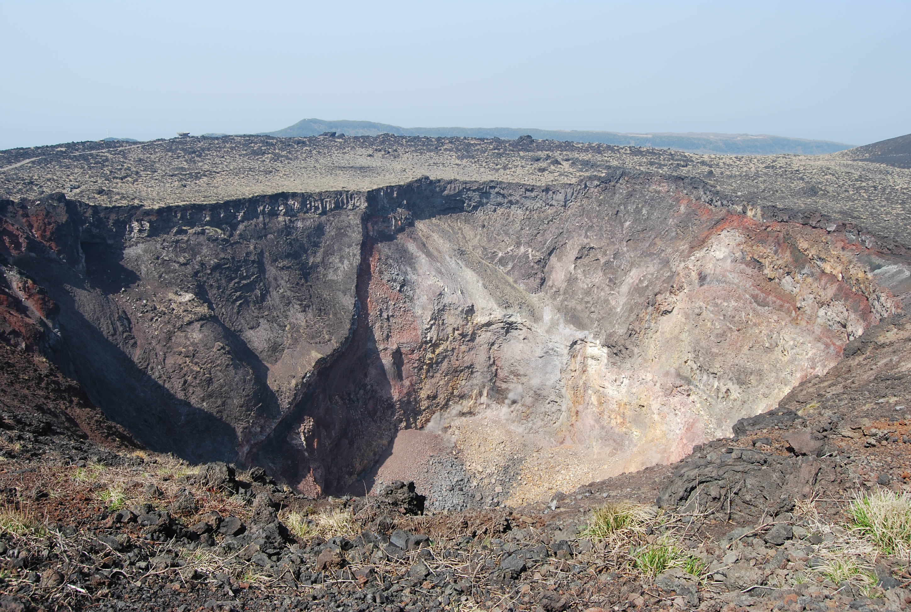
Izu Oshima is a stratovolcano built from basalt, its foundations reaching down to an ocean floor hundreds of meters below the surface. The island's roughly circular coastline -- about 52 kilometers around -- is the visible rim of a volcanic cone that began forming between 10,000 and 15,000 years ago during the late Pleistocene. Written records of eruptions stretch back to the Nara period, more than 1,200 years ago. The most dramatic modern event came in 1986, when Mount Mihara sent lava fountains 1.6 kilometers into the sky and produced a subplinian ash plume reaching 16 kilometers in altitude. The eruption's Volcanic Explosivity Index rating of 3 prompted the evacuation of all 12,000 residents by a fleet of military and civilian vessels. Smaller eruptions followed in 1990, the last recorded activity. Today, the island's volcanic alert level sits at 1 -- a reminder that the fire beneath is resting, not gone.
Six Hamlets on the Rim
Life on Izu Oshima is organized around six traditional hamlets: Okata, Motomachi, Senzu, Nomashi, Sashikiji, and Habuminato. Motomachi serves as the administrative center, its port receiving ferries from both Tokyo and Atami on the Shizuoka coast. The island operates under the Oshima subprefecture of the Tokyo Metropolitan government -- a quirk of Japanese administration that places these subtropical villages under the same bureaucratic umbrella as Ginza. Oshima Airport connects the island to Chofu Airport with several daily flights, making it one of the most accessible volcanic islands in the Pacific. Tourists come for the hiking trails up Mount Mihara, the hot springs fed by volcanic heat, and Ura-Sabaku, a landscape of scattered rock and ash that earned the distinction of being called Japan's only desert.
A Sanctuary for Wings
BirdLife International has designated Izu Oshima as an Important Bird Area, and the reason becomes clear in the island's dense subtropical forests. Japanese wood pigeons -- large, dark birds found almost nowhere else -- nest in the canopy alongside Ijima's leaf-warblers, a species endemic to the Izu and Ryukyu island chains. The Izu thrush, with its distinctive orange bill, forages in the undergrowth, while the elusive Pleske's grasshopper warbler hides in dense vegetation. These species thrive here precisely because the island's volcanic nature has kept large-scale development at bay. The humid subtropical climate delivers abundant rainfall year-round, sustaining the forests that shelter these rare birds from the pressures facing their mainland cousins.
Monster Island
Few real places have hosted as many fictional catastrophes as Izu Oshima. In the 1984 film The Return of Godzilla, the Japanese Self-Defense Forces lure the King of the Monsters to Mount Mihara's crater, where detonated charges send him plummeting into the magma. Five years later, in Godzilla vs. Biollante, he claws his way back out when the volcano erupts. Gamera's 1965 debut film also used the island as its climactic battleground. Beyond kaiju cinema, Koji Suzuki chose Mount Mihara as a pivotal location in his horror novel Ring and its iconic 1998 film adaptation. Even Pokemon drew from the island -- Cinnabar Island, home to a volcanic gym, is modeled on Izu Oshima. Nobel laureate Yasunari Kawabata gave the island a literary role in The Dancing Girl of Izu, adapted for film multiple times. The island's dramatic volcanic landscape apparently makes it irresistible to storytellers.
From the Air
Izu Oshima sits at 34.74N, 139.40E in the Philippine Sea, approximately 100 km south-southwest of central Tokyo. The island appears as a distinct circular landmass with the dark cone of Mount Mihara clearly visible from above. Oshima Airport (RJTO) has a 1,800-meter runway oriented 03/21. Nearest mainland airports include Tokyo Haneda (RJTT) approximately 100 km northeast and Oshima is also reachable from Chofu Airport (RJTF). Expect maritime weather conditions with frequent cloud buildup around the volcanic peak. The surrounding Izu island chain extends south and provides visual stepping stones for navigation. Sagami Bay lies to the northwest, with the Izu Peninsula visible to the west in clear conditions.