Jackson Ward
Bill 'Bojangles' Robinson learned to dance on these streets. A bronze statue of him mid-step, tapping his way up a staircase, still stands at the intersection of Chamberlayne Parkway and West Leigh Street in Richmond, Virginia. It marks the heart of Jackson Ward, a neighborhood that earned the title 'Harlem of the South' not as flattery but as fact. For more than a century, this small district less than a mile from the Virginia State Capitol was the center of African-American commerce, culture, and resistance in the upper South. Duke Ellington, Ella Fitzgerald, Billie Holiday, Cab Calloway, Nat King Cole, and James Brown all performed along 2nd Street, known simply as 'The Deuce,' where the Hippodrome Theater anchored a thriving stretch of the Chitlin' Circuit.
Black Wall Street on the James
Jackson Ward's identity as a center of Black enterprise ran deep. The neighborhood was home to Maggie L. Walker, the first African-American woman to charter and serve as president of a bank in the United States, the St. Luke Penny Savings Bank. Charles Thaddeus Russell, one of Virginia's first licensed Black architects, designed homes and businesses throughout the ward, employing Black workers and contractors on nearly every project. The neighborhood's commercial vitality was so concentrated that it earned the name 'Black Wall Street of America.' Named for its political ward designation within Richmond from 1871 to 1905, Jackson Ward kept its name long after the administrative boundary ceased to exist, because it had come to mean something far larger than a voting district. Listed as a National Historic Landmark District in 1978, its architectural legacy spans Federal-style cottages from the early 1800s, Greek Revival homes from the antebellum decades, and ornate Italianate facades from the 1850s onward.
The Highway That Cut a Neighborhood in Half
In 1954, the Virginia General Assembly, which had no Black members at the time, created the Richmond-Petersburg Turnpike Authority. Four months later, the authority announced the highway would be built through Jackson Ward. Richmond voters had twice rejected the turnpike in public referendums, but the state overruled them. The expressway destroyed 1,000 homes, cut a block-wide canyon through the neighborhood's historic center, blocked 31 streets, and severed the pedestrian connections that had held the community together. One building survived on the north side of Duval Street: Sixth Mount Zion Baptist Church, established in 1867 by the Reverend John Jasper. The church secretary, Cerelia Johnson, worked as an elevator operator in City Hall and overheard plans for the highway route. She relayed what she learned to the pastor, Dr. A.W. Brown, and the congregation fought to reroute the road just enough to spare the building. The turnpike opened in 1958, but Sixth Mount Zion lost 1,000 members to the displacement.
The Lawyers Who Changed America
Jackson Ward was not just a cultural hub but a command center for the Civil Rights Movement in Virginia. Lawyers Oliver Hill, Martin A. Martin, and Spottswood William Robinson III practiced from offices in the neighborhood, working with the NAACP to bring case after case against the segregated order. Their firm secured pay equity for Black teachers before World War II. After the war, they turned their attention to the schools themselves. They represented the plaintiffs in Davis v. County School Board of Prince Edward County, one of the five cases consolidated into the Supreme Court's landmark Brown v. Board of Education decision in 1954, which declared segregation in public schools unconstitutional. The legal fight continued through the Massive Resistance crisis of 1955 to 1965, when Virginia officials tried to close public schools rather than integrate them. After Martin's death, the firm continued under Hill, joined later by Samuel Wilbert Tucker and Henry L. Marsh, who would become Richmond's first Black mayor.
Buried and Rediscovered
Beneath Jackson Ward lies the Shockoe Hill African Burying Ground, likely the largest burial ground for free people of color and enslaved individuals in the United States. Established in 1816 as two one-acre plots by the city of Richmond, it eventually expanded to over 31 acres and received an estimated 22,000 interments before closing to new burials in 1879. For generations, the site was essentially invisible, paved over and built upon as the city grew. In 2022, the burial ground was added to the Virginia Landmarks Register and the National Register of Historic Places. Its heart is located at 1305 North 5th Street. The rediscovery and recognition of this ground is a reckoning with the layers of history that Jackson Ward holds, from the silenced dead to the vibrant living community that built something extraordinary above them.
Revival and Reckoning
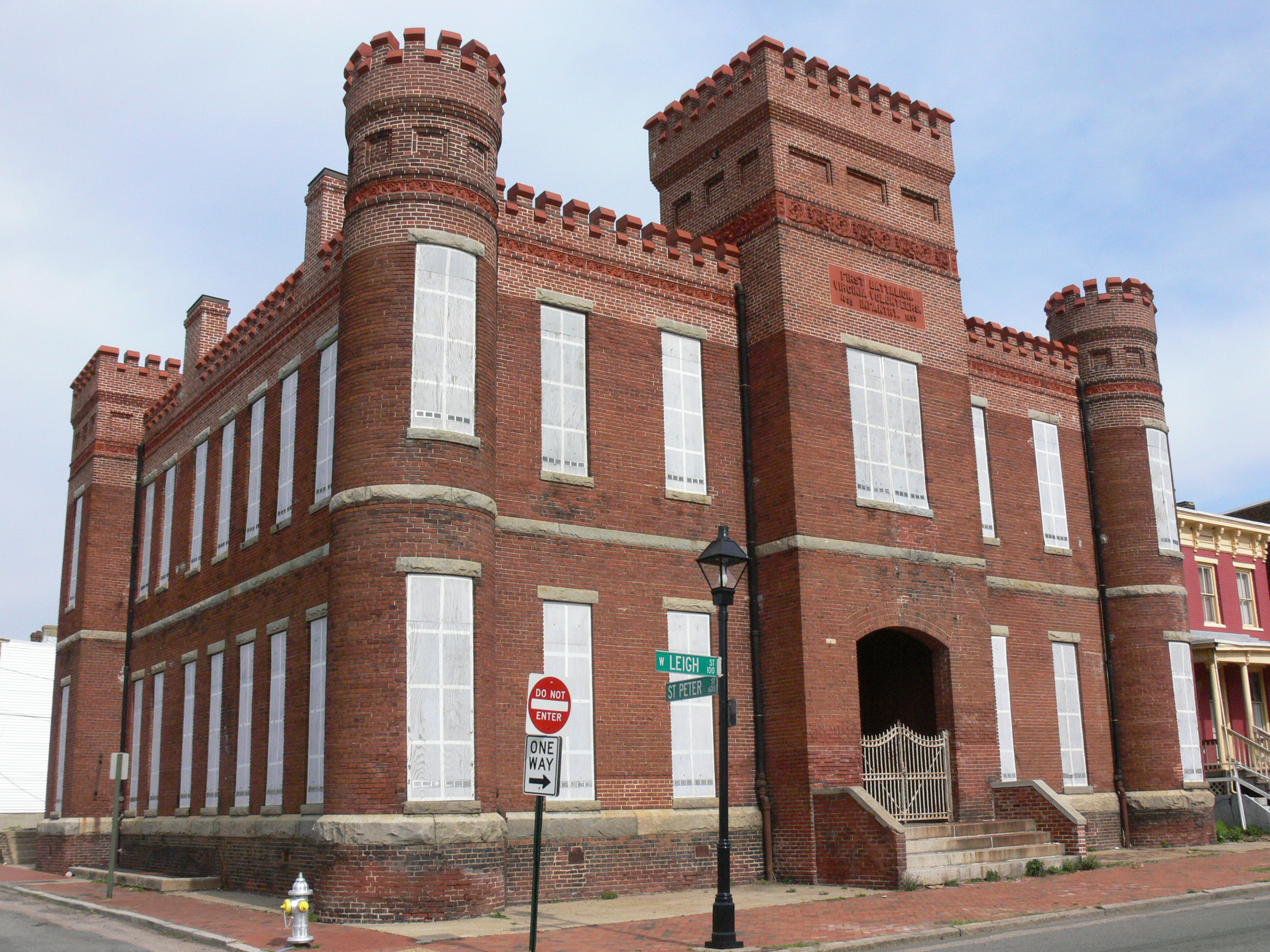
Today Jackson Ward is changing again. The National Park Service restored the Maggie L. Walker House. The Leigh Street Armory, a Victorian-era military building, was refurbished and reopened in 2016 as the Black History Museum and Cultural Center of Virginia. First Fridays Artwalk draws crowds to Broad Street each month, galleries spilling into the night air alongside jazz and salsa music. But the revival carries tension. In 2000, Jackson Ward still had a majority African-American population. By 2010, nearly twice as many white residents as Black lived in the neighborhood. The gentrification that brought investment also displaced the community that gave the ward its identity. New mixed-use construction rises alongside the restored Federal and Greek Revival houses. Jackson Ward endures as it always has, carrying the weight of its past while the present reshapes itself around it.
From the Air
Located at 37.55N, 77.44W in downtown Richmond, Virginia, immediately north of Broad Street and west of Court End. From the air, the neighborhood is bisected by the I-95 expressway corridor, the scar of the 1958 Richmond-Petersburg Turnpike still visible as a wide gash through the urban grid. The Virginia State Capitol dome is visible less than a mile to the southeast. Abner Clay Park and the former Armstrong High School mark the neighborhood center. Nearest airport is Richmond International (KRIC), approximately 7 miles southeast. Best viewed at 2,000-3,000 feet AGL to appreciate the contrast between the historic street grid and the highway that severed it.