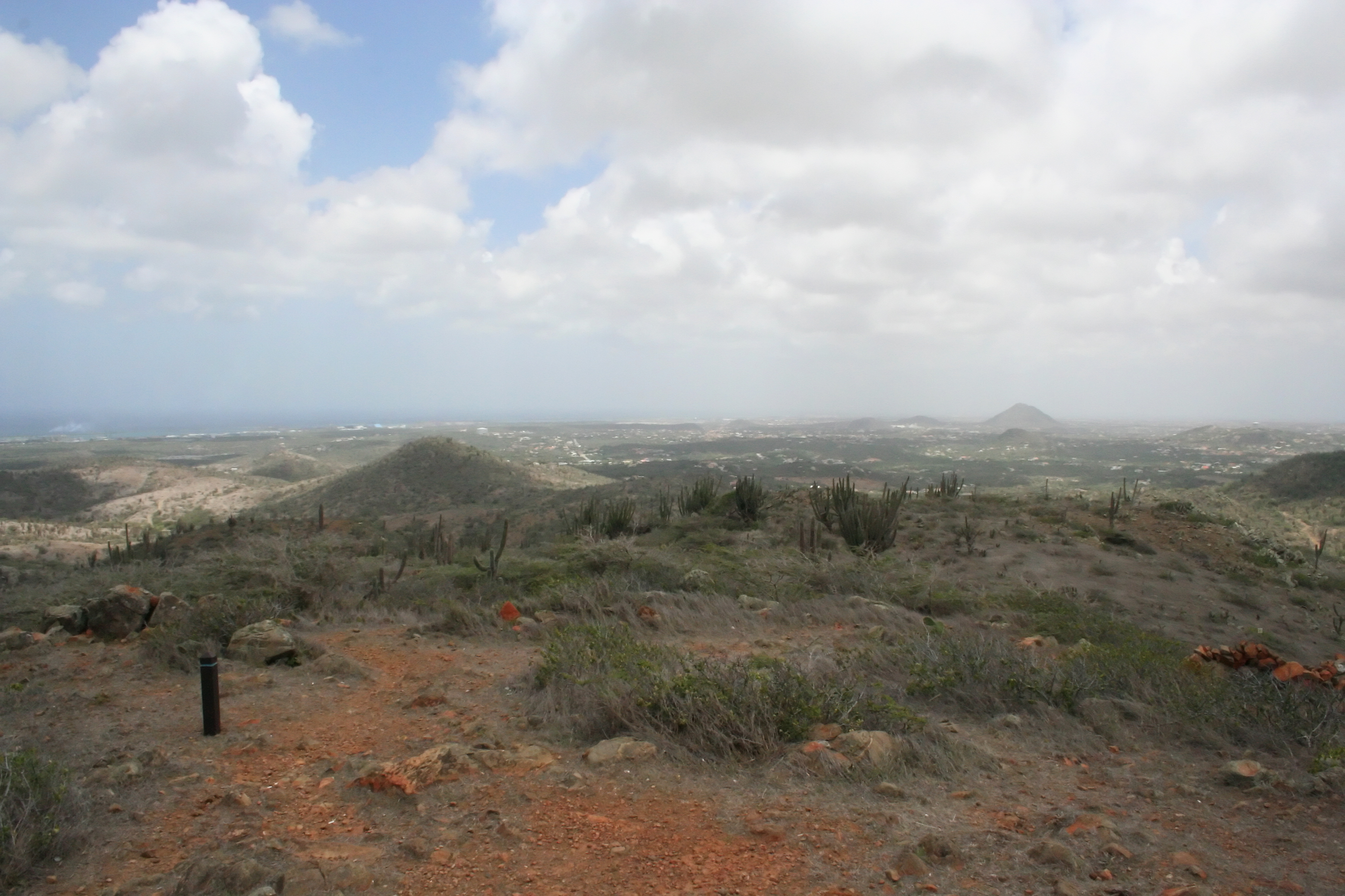
Jamanota
The Arawak name breaks down like a prayer: JA for spirit, MA for great, NO for plural, TA for source. Jamanota -- Source of Great Spirits. At 188 meters, it is the highest point on an island most visitors never think to climb. Aruba markets itself on white sand and turquoise water, but here in Arikok National Park, the island reveals something older: undulating hills of volcanic rock, wind-twisted trees bent permanently south, and a silence broken only by rattlesnakes moving through thorn scrub. From the summit, the entire island unfolds -- Palm Beach towers to the northwest, Frenchman's Pass along the coast below where Arawak defenders once fought off French invaders. The view is a compressed history of Aruba: indigenous resistance, colonial ambition, and tourism, all visible from a single hilltop.
Fire Turned to Stone
The hills around Jamanota are among the oldest formations on Aruba, part of the Aruba Lava Formation that stretches 3 kilometers deep and covers roughly 20 square kilometers. This is basalt and dolerite country -- volcanic rock weathered into rolling terrain that looks nothing like the flat limestone terraces covering Aruba's western coast. The formation is primarily basalt (41%) and dolerite (24%), with layers of volcanic conglomerate, sandstone, and tuff compressed between them. Pillow lavas and sheet flows record eruptions both submarine and terrestrial. Nearby Arikok hill reaches 185 meters, just three meters shorter, and the two summits anchor a landscape geologists once classified as Diabase-Schist-Tuff before reclassifying it under the broader Aruba Lava Formation. The rock beneath your boots is the same type used to build the bluestone pillars at Stonehenge -- diabase, dark-grained and dense, cooled slowly through shallow intrusions into the earth's crust.
The Rattlesnake's Kingdom
Somewhere in the thorn scrub between the diabase hills and the limestone plateau lives one of the world's rarest vipers. The Aruba Island rattlesnake, Crotalus unicolor, is endemic to this single island -- it exists nowhere else on Earth. Pale gray to bluish-gray, sometimes brown, with barely any pattern on its scales, it blends into volcanic rock so thoroughly that hikers pass within meters without noticing. Its belly often flushes pinkish-orange, a startling flash of color on an otherwise monochrome animal. The rattlesnakes range from sea level to Jamanota's summit, hunting rodents, birds, and lizards in the early morning and late afternoon, switching to nocturnal activity during hotter months. The species faces an unlikely threat: goats. Freely roaming herds trample through rattlesnake habitat, and the snakes -- which rattle their warning but refuse to flee -- are sometimes killed by hooves that cannot interpret the sound.
Goat Island
The goats arrived with the Spanish in the 16th century, after Spain declared the ABC islands useless for lacking precious resources. Aruba became a rancho where herds roamed without fences. By 1661, the Dutch West India Company was calling Aruba and Bonaire the "goat islands." The logic was simple: in an arid climate where cattle starved, goats thrived without tending or irrigation. Spanish colonists from Catalonia and Galicia preferred goat's milk to cow's, and the animals became the island's primary export -- meat shipped to Curacao. As of 2015, an estimated 43 goats per square kilometer roamed Arikok National Park, roughly 1,465 animals competing with every other species for limited vegetation. They gnaw the Cadushi cactus to death, destroying a food source for bats and birds. They spread Hubada acacia seeds while eliminating competing plants, making the landscape monotonous. Four centuries after their introduction, the goats remain -- thriving, destructive, and thoroughly Aruban.
Wind-Bent Witnesses
You can spot a Watapana tree from a considerable distance by its shape alone. Also called Dividivi, the Caesalpinia coriaria grows permanently bent by Aruba's trade winds, its canopy swept to one side like an umbrella caught in a gale. The tree once sustained an entire seasonal economy. Women and children beat pods from the branches with sticks, earning twenty-five Dutch cents for every 20 kilograms gathered. The pods shipped to Hamburg via Curacao, where tanneries along the Elbe processed the tannin into leather for East European farmers' boots. In peak years, Aruba exported 303,000 kilograms of Dividivi pods at sixty to eighty Dutch guilders per ton. The harvest came twice yearly -- January and June or July -- with dry years producing better crops than rainy ones. The trade is long gone, but the Watapana still bends on Jamanota's slopes, a living compass pointing leeward, holding the memory of a commerce that once connected this tiny Caribbean island to the tanneries of northern Europe.
Wings Over the Summit
Jamanota's skies once belonged to the White-tailed Hawk, a raptor believed to have nested exclusively in this area. Unverified sightings in 1988 and 1997 kept hope alive, but the hawk's presence has never been confirmed since. Its penetrating call -- a sharp "kee-weet, kee-weet" -- may have fallen silent here for good. What remains are the Crested Caracaras, known locally as Warawara, the self-appointed garbagemen of the mondi -- Papiamento for wilderness. These opportunistic raptors nest in the tall columnar cacti that punctuate the hillsides. Arikok National Park covers roughly 20% of Aruba's land area, 32 square kilometers of protected terrain where the island's wild character persists despite centuries of change. From above, the park reads as a patchwork of brown volcanic hills, pale limestone flats, and scattered green where drought-resistant vegetation clusters in arroyos. Jamanota rises at its center, the summit the Arawak named for spirits, where the wind never stops and the view stretches to every shore.
From the Air
Located at 12.49N, 69.94W in the center of Arikok National Park, which covers the eastern 20% of Aruba. Jamanota at 188m (617 ft) is the island's highest point -- visible as a rounded summit among undulating brown hills in the park's interior. From altitude, the contrast between Aruba's developed western coast (hotels, high-rises) and the rugged eastern parkland is striking. Queen Beatrix International Airport (TNCA/AUA) lies approximately 8 km to the west-northwest. The island is only 32 km long and 10 km wide, so the entire landscape is visible from moderate altitude. Look for the wind-bent Watapana trees and columnar cacti dotting the volcanic hills. Best viewed at 2,000-4,000 ft for terrain detail. Persistent trade winds from the east-northeast; generally clear skies with excellent visibility.