Jamek Mosque
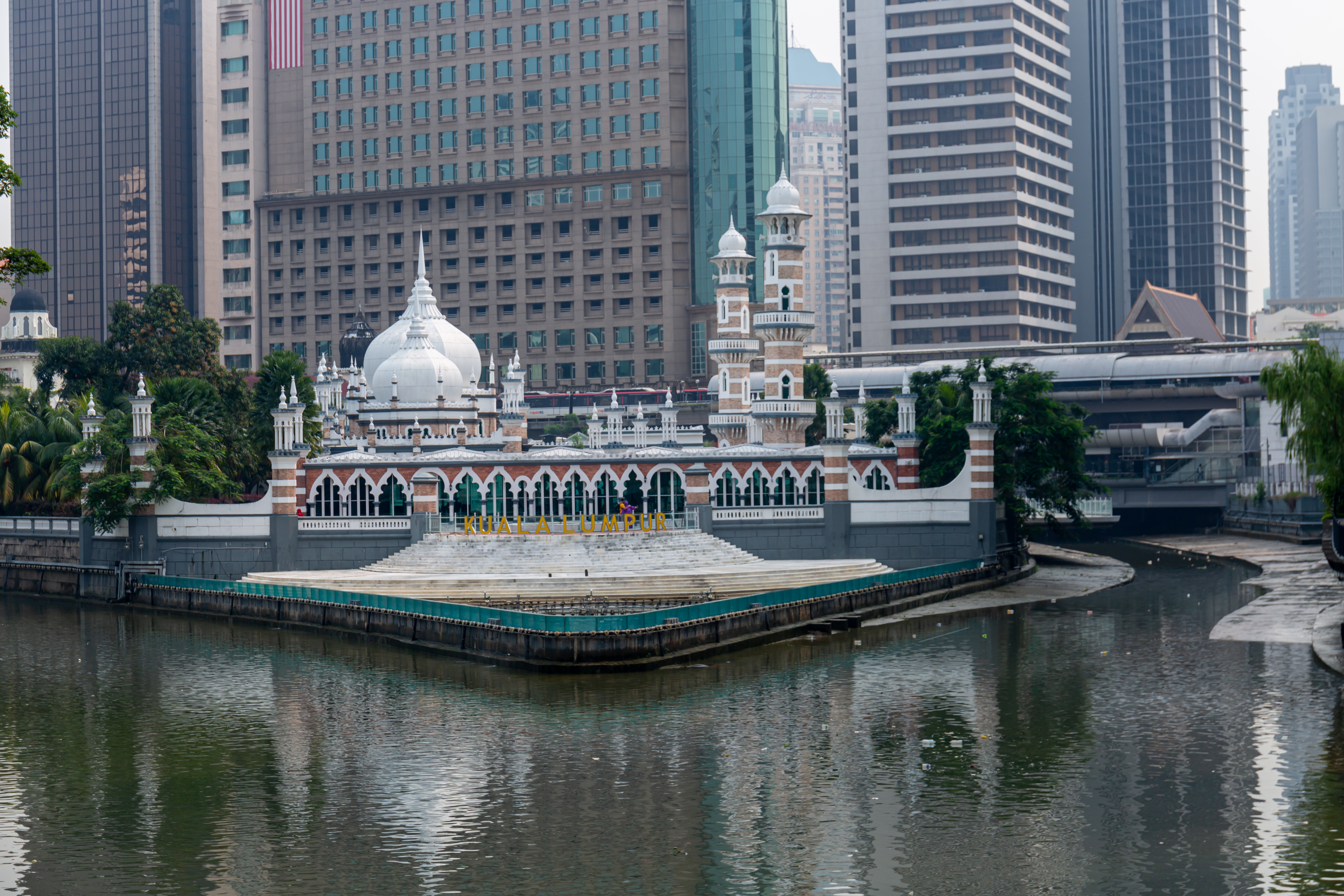
Two rivers made Kuala Lumpur. The Klang flows in from the west, the Gombak from the north, and where they meet -- in a wedge of land that was once a Malay burial ground -- tin miners established the settlement that would become Malaysia's capital. The Jamek Mosque has occupied that exact confluence since 1909, its pink-and-white minarets rising from the point where the city's two founding waterways become one. The name says what it is: "Jamek" comes from the Arabic jami, a place where people gather to worship. For over a century, they have.
The Soldier Who Built Mosques
Arthur Benison Hubback was a British military officer and architect whose fingerprints are all over colonial Kuala Lumpur. He designed the Jamek Mosque in the Indo-Saracenic style, drawing on the Mughal architecture of northern India -- onion domes, cusped arches, and ornamental towers -- to create something that felt both Islamic and imperial. Hubback applied the same approach to the Kuala Lumpur railway station and the Ubudiah Mosque in Kuala Kangsar, giving British Malaya a distinctive architectural language that borrowed from India's Muslim heritage while serving colonial purposes. The Jamek Mosque was the first large mosque built in Kuala Lumpur. Smaller mosques had served the Malay communities along Java Street and Malay Street, but nothing at this scale existed in the young city. The foundation stone was laid on 23 March 1908 by Sultan Sir Alaeddin Sulaiman Shah of Selangor, and the completed mosque opened on 23 December 1909 at a cost of $32,625 -- funded partly by the Malay community, partly by the British colonial government.
Blood and Bandage
The mosque's most striking visual feature is the banding on its two main minarets. Alternating stripes of pink brick and white plaster climb upward in a pattern that observers have described as "blood and bandage" -- a vivid image for a building designed by a military man. Three domes crown the structure, the largest reaching 21.3 meters in height, with the prayer hall sheltered beneath them. The building sits low and broad compared to many mosques, spreading across its riverside site rather than reaching for the sky. This is partly a matter of terrain: the confluence is flat, the ground soft from centuries of river sediment. When one of the domes collapsed in 1993 under the weight of heavy rain, it was a reminder of what it means to build on a floodplain. The dome was repaired. The minaret nearest the river, which had begun to lean, was underpinned during a 1984 refurbishment -- the building slowly adjusting to the unstable ground that made the city possible in the first place.
Fifty-Six Years at the Center
From its opening in 1909 until 1965, the Jamek Mosque served as the principal mosque of Kuala Lumpur. Friday prayers, religious celebrations, and community gatherings all centered on this building at the meeting of the rivers. When the national mosque Masjid Negara was completed in 1965, the Jamek Mosque lost its primacy but not its relevance. It remained a beloved neighborhood institution -- the mosque of the old city, the one that predated the skyscrapers and the highways. Its location between Chinatown and Little India, near Dataran Merdeka (Independence Square), placed it at the crossroads of Kuala Lumpur's diverse communities. The LRT station that took its name -- Masjid Jamek station -- became one of the city's busiest metro interchanges, where the Kelana Jaya, Sri Petaling, and Ampang lines converge.
The Zero Mile
Near the mosque stands the Zero Mile Pillar, a marker indicating the point from which all road distances in Kuala Lumpur were originally measured. It is a fitting companion to the Jamek Mosque. Both mark beginnings: the pillar, the start of the road network; the mosque, the spiritual center of a community that grew around tin and trade. The confluence itself was where Chinese tin miners arrived in the 1850s, drawn upriver by the promise of ore. Many of those early miners died of malaria and flooding -- "Kuala Lumpur" means "muddy confluence," and the name was earned honestly. That the city's oldest major mosque stands on this same patch of difficult, waterlogged, historically significant ground says something about persistence. The rivers still meet here. The mosque still stands. The city that grew from the mud around it now stretches to a horizon of glass towers, but this is where it started.
From the Air
Located at 3.149N, 101.696E in the heart of old Kuala Lumpur, at the visible confluence of the Klang and Gombak rivers. The mosque is easily identified from the air by its position at the river junction, with its three cream-colored domes and pink-banded minarets. Dataran Merdeka (Independence Square) lies immediately to the east. Sultan Abdul Aziz Shah Airport (WMSA) is approximately 15 km west, and Kuala Lumpur International Airport (WMKK) is about 50 km south. Best viewed at 2,000-3,000 ft AGL. The Petronas Twin Towers, roughly 1.5 km to the east, provide an unmistakable landmark for orientation.