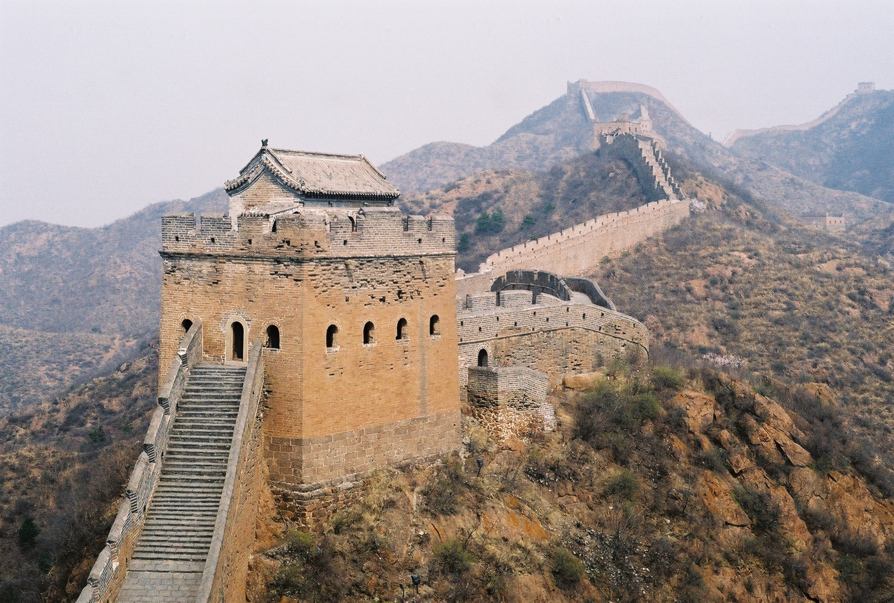
Jinshanling
Photographers know Jinshanling the way musicians know Carnegie Hall -- it is the place where you go to prove your craft. This 10.5-kilometer section of the Great Wall, draped across the mountains of Luanping County in Hebei Province, offers the combination that most Great Wall sections cannot: dramatic topography, dense watchtower spacing, and a gradient from restored stonework to wild, crumbling ruin. Walk east from the cable car station and the wall transforms beneath your feet, from neatly laid brick to jagged remnants half-swallowed by vegetation, until it meets the even wilder Simatai section at the far end.
Sixty-Seven Towers on a Dragon's Back
Jinshanling was built beginning in 1570 during the Ming dynasty, part of the massive defensive construction campaign that produced the Great Wall sections most people recognize today. The numbers are striking: across 10.5 kilometers of wall, the builders erected 5 passes, 67 watchtowers, and 3 beacon towers. That density -- roughly one tower every 150 meters -- reflects the Ming military's obsessive approach to frontier defense. Each tower served multiple functions: lookout post, signal relay station, garrison quarters, and strongpoint. From any tower, soldiers could see the adjacent ones in both directions, creating an unbroken chain of visual communication that could relay warnings of approaching threats across enormous distances within minutes.
The Gradient Between Order and Entropy
What makes Jinshanling distinctive among Great Wall hiking destinations is its transitional character. The western sections near the main entrance have been carefully restored to their original condition -- smooth brick surfaces, intact parapets, rebuilt watchtower interiors. As you walk east toward the Simatai section, the restoration gives way to increasing wildness. Bricks loosen, vegetation pushes through gaps, and entire tower walls have collapsed into rubble. This gradient gives hikers the rare experience of watching centuries of weathering unfold in a single walk. It is one thing to see a perfectly restored wall; it is another to stand in a tower where the roof has fallen in and trees grow from the floor, and to understand that this is what time does to even the most ambitious human constructions.
Where the Wall Connects
Jinshanling sits at a strategic midpoint in the Great Wall's geography northeast of Beijing. To the east, it connects with the Simatai section, famous for its steepness and dramatic Sky Bridge. To the west, some distance away, lies the Mutianyu section, one of the most popular tourist destinations. Jinshanling itself is 125 kilometers northeast of central Beijing, far enough to discourage casual day-trippers but close enough to attract serious hikers and photographers. The location in Luanping County places it technically within Chengde prefecture in Hebei Province, though it is functionally part of the Beijing orbit. A cable car carries visitors to the highest point, and a suspension bridge connects the Jinshanling and Simatai sections for those willing to continue the traverse.
Morning Light on the Ridgeline
The early morning is when Jinshanling earns its reputation. As the sun rises over the mountains to the east, it catches the watchtowers in sequence, illuminating each one in turn as the shadows retreat down the slopes. Mist often fills the valleys below, leaving the wall floating above a sea of white -- a scene that has graced countless photographs and travel posters. But the real experience is more physical than visual. The wall here is not flat. It rises and falls with the mountain ridgeline, climbing steep stone staircases between towers, dipping into saddles, then ascending again. By the time you reach the unreconstructed sections, your legs are burning and the tourist infrastructure has fallen away completely. It is just you, the crumbling brick, and the mountains stretching in every direction, carrying the wall toward horizons you cannot quite see.
From the Air
Located at 40.68N, 117.25E in the mountainous terrain of Luanping County, Hebei Province. The Great Wall is clearly visible from the air as a sinuous line following the mountain crests. The section connects with Simatai to the east and stretches toward Gubeikou to the west. Nearest major airport is Beijing Capital International (ZBAA/PEK), approximately 125 km to the southwest. Terrain is rugged and mountainous. Best viewed from 3,000-6,000 feet AGL for wall detail.