Joffre Lakes Provincial Park
The parking lot fills before dawn. By 7 AM on summer weekends, cars line Highway 99 for a kilometer in each direction, their occupants clutching day-use passes obtained precisely 48 hours earlier when the booking window opened. Joffre Lakes has become a victim of its own photogenic perfection - those three electric-blue lakes, each pooled at a different elevation beneath the Matier Glacier, have graced so many Instagram feeds that the park system had to implement reservations just to prevent the trail from being loved to death. The irony is thick: a wilderness experience now requires the same advance planning as a restaurant reservation. Yet those who make it through the bureaucracy and up the trail discover that some cliches exist for good reason. These lakes really are that blue.
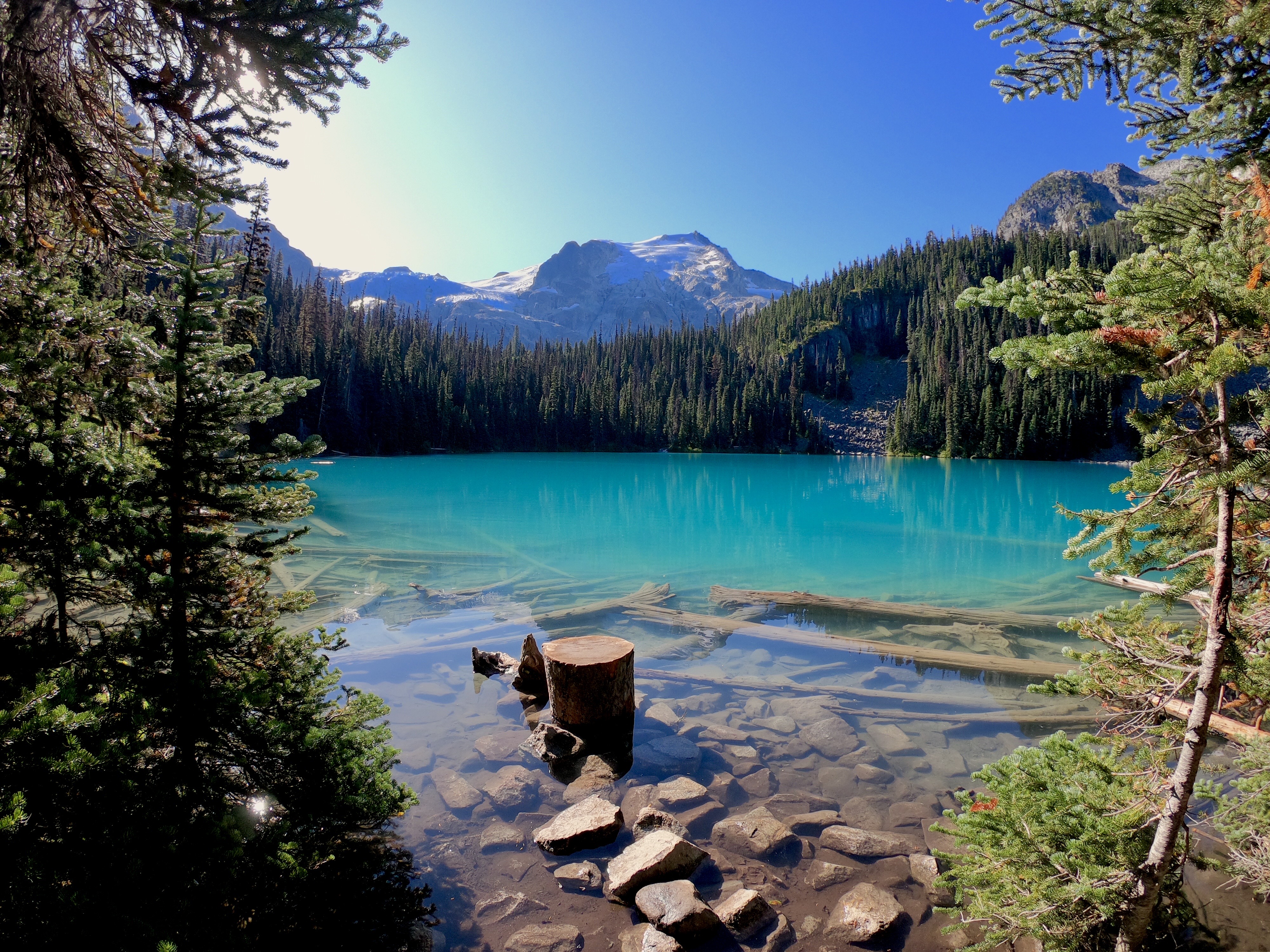
The Color of Cold
Lower Joffre Lake sits mere steps from the parking lot - a teaser, a promise of what lies ahead. Its waters carry that distinctive glacial hue, the result of rock flour suspended in meltwater scattering light just so. But Lower is merely the appetizer. Middle Joffre Lake, reached after steady climbing through subalpine forest, deepens the color palette. Upper Joffre Lake, the finale, rests at the base of the glacier itself, its waters so vividly turquoise they seem artificially enhanced. They're not. This is simply what happens when ice grinds rock to powder over millennia, and that powder finds its way into still, deep water. The mountains here exceed 2,500 meters, their bulk reflected in waters cold enough to stop your heart.
The Trail That Sorts
Joffre Lakes self-selects its visitors. Lower Lake welcomes everyone - families with strollers, tourists in sandals, anyone capable of a five-minute walk. Middle and Upper Lakes demand more. The trail climbs relentlessly, roots and rocks underfoot, gaining elevation through forest that gradually thins as you rise. For experienced hikers, it's a moderate challenge taking perhaps ninety minutes each way. For the unprepared - and many are unprepared - it becomes an ordeal. The park website doesn't mince words: bring proper footwear, carry your own water, expect no cell service. The beauty at the end doesn't care about your fitness level or your schedule. It was here before you arrived and will remain long after you've limped back to your car.
Bureaucracy as Conservation
The day-use pass system frustrates visitors accustomed to spontaneous adventure. You must book through the BC Parks website exactly two days in advance, starting at 7 AM, competing with thousands of others for limited slots. Miss your window, and you wait or drive elsewhere. The campground requires similar planning, and winter visitors face a hard closure from November 15 through April 15 - not for cold, but for avalanche danger that makes the trail potentially lethal. These restrictions emerged from necessity. Peak summer days once saw parking overflow onto the highway, trail erosion accelerating, and alpine meadows trampled by sheer volume of boots. The park was being degraded by its own popularity. Whether the current system adequately balances access and preservation remains debatable, but the alternative was watching a wilderness become a theme park.
Beyond the Famous View
Most visitors photograph Upper Lake, rest briefly, and return the way they came. They miss the quieter pleasures: the way morning light transforms Middle Lake's surface into a mirror, the old-growth cedars that somehow survive at this elevation, the pikas whistling warnings from boulder fields along the trail. They miss the sound of the glacier creaking overhead, audible on still days, a reminder that this landscape is not static but slowly, constantly moving. Pemberton lies thirty minutes west, a small town offering food and fuel and lodging for those making a day of it. Highway 99 continues north toward Lillooet and the Cariboo, or south toward Whistler and Vancouver. But for those who secured their passes and made the climb, nowhere else seems relevant for a while.
From the Air
Located at 50.34N, 122.48W in the Coast Mountains northeast of Pemberton. The three lakes step up the mountainside beneath the Matier Glacier, visible as distinct turquoise pools from altitude. Joffre Peak (2,721m) and Matier Peak dominate the skyline. Highway 99 passes the parking lot, making the park visible from low approaches. Nearest airports: Pemberton Regional (YPS) 35km west, Squamish Municipal (YSE) further south, Vancouver International (YVR) approximately 160km southwest. Terrain is steep with rapid elevation gain from highway level (approximately 1,200m) to upper lake (1,500m+). Heavy winter snowfall; avalanche terrain surrounds the area.