Jost Van Dyke
The island did not get electricity until 1991. There are no ATMs, no banks, no fast food, and until recently, no paved roads beyond the main settlements. Jost Van Dyke -- the smallest of the four main British Virgin Islands -- operates on a schedule governed less by clocks than by tides, ferry arrivals, and the whims of bar owners who open when they feel like it. About 300 people live here year-round, outnumbered on any given day by the sailboats anchored in Great Harbour, White Bay, and Little Harbour. The island is named for the Dutch privateer Joost van Dyk, who sailed these waters in the early 1600s and reportedly used the island as a hideout between raids, though no firm evidence of his presence survives beyond the name itself.
A Privateer, a Patron, and a Capitol
Joost van Dyk was not merely a pirate -- he was a colonizer. By 1615, Spanish records documented his settlement as a growing community of Dutch, French, and English freebooters who farmed cotton and tobacco between raids. When the truce between the Dutch Republic and Spain expired in 1620, Van Dyk built a more substantial earthen fort, and by 1625 the Dutch West India Company recognized him as the private "Patron" of Tortola. He eventually moved his operations to Road Town, but his name stuck to the small island across the channel. Centuries later, the island produced a far more unlikely figure: William Thornton, born on Little Jost Van Dyke in 1759 to a Quaker family that had settled the island around 1720. Sent to England at age five for schooling, Thornton grew up to be a physician, painter, and amateur architect who won the competition to design the United States Capitol. George Washington himself approved the design in 1793.
The Soggy Dollar and the Painkiller
White Bay is where the island's modern reputation was built -- or more accurately, mixed. The Soggy Dollar Bar, tucked into the beach at White Bay, is the birthplace of the Painkiller: a blend of Pusser's dark rum, cream of coconut, pineapple juice, and orange juice, finished with freshly grated nutmeg. The bar earned its name from the fact that there is no dock -- sailors anchor offshore and swim in, arriving with waterlogged currency. The drink became so famous that Pusser's trademarked the name, and variations of it are now served across the Caribbean. But on Jost, the Painkiller is less a cocktail than a unit of time. Order one, and by the time it arrives, you will have adjusted to the island's pace. Order two, and you will have forgotten you had anywhere else to be. The honor bars scattered across the island take this philosophy further: liquor and mixers are left out for guests to pour their own, with each person keeping an honest tally of what they drank.
After the Storms
In September 2017, Hurricane Irma hit the British Virgin Islands as a Category 5 storm, and Jost Van Dyke took the full force. Satellite images from before and after tell the story in two colors: the island was green, then it was brown. Most buildings were destroyed, vegetation was stripped bare, and the infrastructure -- such as it was -- was shattered. Weeks later, the outer eyewall of Hurricane Maria swept across the islands. Recovery on Jost has been slow and largely self-directed, driven by the same islanders who rebuilt their homes, their bars, and their docks by hand. By 2019, most facilities had reopened and visitors had returned. Souvenirs sold on the island now fund the ongoing rebuilding effort. The yellow Methodist Church in Great Harbour, once a landmark, remains in ruins -- a visible reminder that the storms reshaped the island in ways that years of recovery have not fully undone.
Island Time, Literally
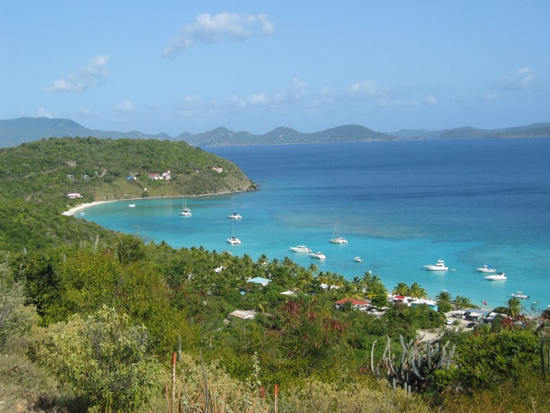
Getting to Jost Van Dyke requires water. The most frequent ferry runs from West End, Tortola -- a 25-minute crossing to Great Harbour. Weekend ferries from Red Hook on St. Thomas take an hour via Cruz Bay on St. John. Most visitors arrive by sailboat, anchoring in one of the three main harbors and dinghying to shore. Once on the island, transportation is walking, hitchhiking, or renting a 4x4 from a local -- keys under the mat when you return it to the ferry dock. The hilly terrain makes every walk a workout, but the 15-minute path from Great Harbour over the ridge to White Bay is one of the most beautiful short walks in the Caribbean, with views stretching from Tortola across St. John to St. Thomas. At the bottom of the hill, White Bay's sand is so bright it hurts to look at without sunglasses. The point of Jost Van Dyke, as the locals will tell you, is to do precisely nothing -- stare at the water, turn a page, order another Painkiller, and let the island's rhythm replace your own.
From the Air
Located at 18.45N, 64.73W, Jost Van Dyke is the smallest of the four main British Virgin Islands, visible northwest of St. John and west of Tortola across the Sir Francis Drake Channel. The island is roughly oval, with protected bays visible on the south and east sides (Great Harbour, White Bay, Little Harbour) and rocky, inaccessible coastline on the north and west. Sandy Cay and Little Jost Van Dyke are small islets off the eastern coast. Nearest major airport is Terrance B. Lettsome International Airport (TUPJ) on Beef Island, Tortola, approximately 8nm east. Cyril E. King Airport (TIST) on St. Thomas is approximately 12nm south. No airstrip on Jost Van Dyke. Sailboats anchored in the bays are a distinctive visual feature from moderate altitude.