Joya de Ceren
The sleeping mats had not been unrolled. Fires still burned in the hearths. Agricultural tools were stowed beside doorways, and vessels filled with achiote seeds sat among ceremonial objects in what appears to have been a ritual interrupted mid-ceremony. Around AD 600, the roughly 200 residents of a small Maya farming village in the Zapotitan Valley of El Salvador received just enough warning -- likely an earthquake measuring about 4.0 on the Richter scale, possibly followed by steamy emissions from the nearby Loma Caldera volcano -- to flee into the early evening. They left behind everything. Then ten meters of volcanic ash buried it all, preserving the village in such extraordinary detail that archaeologists would later call it the "Pompeii of the Americas." UNESCO agreed, designating Joya de Ceren a World Heritage Site in 1993.
An Ordinary Evening, Interrupted
The clues archaeologists pieced together paint a remarkably specific picture of the moment the village was abandoned. The position of artifacts suggests early evening: farm tools had been put away after the day's work, hearth fires were lit for cooking, but sleeping mats remained rolled and stored. The ash that buried Joya de Ceren fell fast -- a layer four to eight meters thick blanketed the settlement within hours -- and at a low enough temperature to preserve organic material that would normally decompose within weeks. Plaster casting techniques, similar to those used at Pompeii, allowed researchers to identify fruiting plants. The abundance of beans in storage and the maturity of the maize crop point to an August or September eruption. No human remains have ever been found at the site, which means the warning, whatever its exact nature, worked. Everyone got out alive.
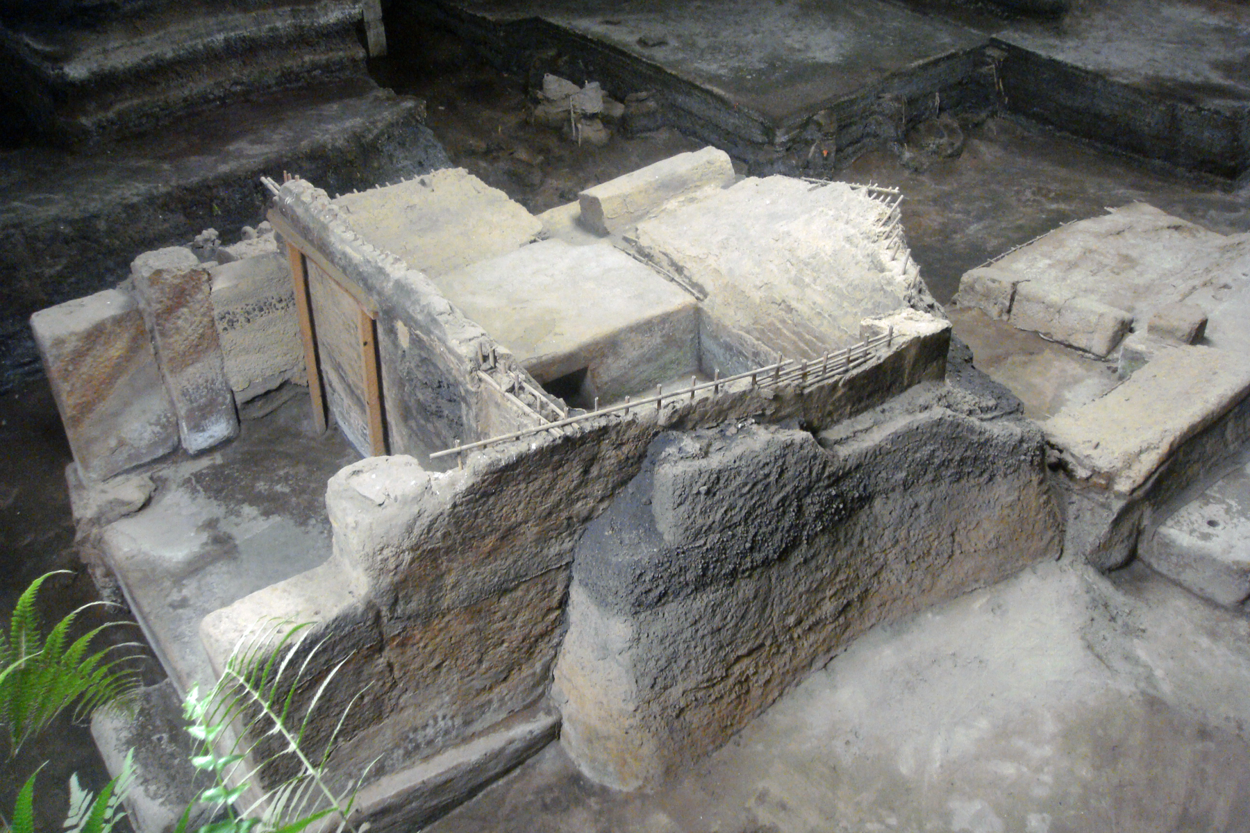
What the Ash Kept
Most Maya archaeological sites preserve stone and ceramics. Joya de Ceren preserved a world. Approximately 70 buildings have been uncovered since excavations resumed in 1988: storehouses, kitchens, living quarters, workshops, a religious structure, and a communal sauna. The paleoethnobotanical record is unmatched for a Maya site -- researchers identified crops of guava, agave, cacao, and manioc, the last being the first confirmed instance of manioc cultivation at any New World archaeological site. The village's households were built from earthquake-resistant wattle-and-daub walls and adobe columns, practical construction for a volcanically active region. Each household cluster included milpas -- the traditional Mesoamerican mixed-crop gardens -- along with fruit trees and trash pits. The mundane details are what make Joya de Ceren extraordinary: this is not a temple complex or a royal tomb, but the daily life of ordinary farmers preserved as if under glass.
Ceremonies and Commerce
Not everything at Joya de Ceren was domestic. Structure 10, a multi-roomed building with corridors for food preparation and vessel storage, has been interpreted as a space for community festivals. A red-painted deer and twine headdress recovered from inside the structure connects it to fertility and harvest rituals. Structure 12 also appears to have served religious purposes. The village economy balanced local production -- agave fibers, metates for grinding corn, pottery -- with imported goods acquired from markets outside the community. Obsidian and chert cutting tools, jade from the Sierra de las Minas to the north, and decorated pottery from Copan all found their way to this small settlement, evidence that even a farming village of 200 people participated in the broader Maya trade networks that connected communities across hundreds of kilometers.
Found by Accident, Studied for Decades
In 1976, a bulldozer operator leveling ground for a government agricultural project cut into something unexpected. The first structures exposed were buildings from the northeastern area of the village. Payson Sheets, a professor of anthropology at the University of Colorado at Boulder, began systematic exploration in 1978 and returned in 1980. Excavation resumed in 1988 and has continued since. The site lies 36 kilometers northwest of San Salvador, in the Zapotitan Valley -- an area where volcanic eruptions have interrupted human settlement repeatedly across millennia. The village had been occupied from roughly AD 200 to 600. What makes Joya de Ceren irreplaceable is not its monuments or treasures but its ordinariness: the manioc fields, the cooking hearths, the sleeping mats. For once, archaeology captured not the ambitions of kings but the Tuesday evening of people who farmed, cooked, traded, prayed, and ran when the mountain told them to.
From the Air
Located at 13.83N, 89.36W in the Zapotitan Valley, 36 km northwest of San Salvador, El Salvador. From altitude, the site appears as a small cleared archaeological zone within agricultural flatland in the broad valley. The Loma Caldera volcanic feature is nearby. Nearest major airport is El Salvador International (MSLP), approximately 35 km to the southeast. The San Salvador volcano complex is visible to the east and south. The site sits in relatively flat terrain compared to the volcanic highlands surrounding the valley, making it distinguishable from the air by its excavation shelters and cleared grounds amid farmland.