July 2025 Central Texas Floods
At 4:22 on the morning of July 4, 2025, an Ingram firefighter radioed a Kerr County dispatcher: "The Guadalupe Schumacher sign is underwater on State Highway 39. Is there any way we can send a CodeRED out to our Hunt residents, asking them to find higher ground or stay home?" The dispatcher said they had to get supervisor approval. The first alert did not go out for another ninety minutes. By then the Guadalupe River had already risen over 26 feet in 45 minutes, shattering every recorded gauge at Hunt before the instruments themselves were swept away. In the span of a few pre-dawn hours, four months' worth of rain fell across the Texas Hill Country. At least 135 people died -- 117 of them in Kerr County alone -- making it the deadliest inland flood in the United States since the 1976 Big Thompson River disaster in Colorado.
Flash Flood Alley
The Texas Hill Country sits atop a geological trap. Shallow soil overlays steep limestone hillsides that shed water rather than absorb it. The Guadalupe River and its tributaries have flooded with deadly regularity: 10 teenagers drowned during a church camp evacuation near Comfort in 1987, 31 people died in October 1998 floods, 13 perished on the nearby Blanco River in May 2015, and 13 more died in San Antonio flooding just three weeks before this disaster. From 1959 to 2019, Texas led the nation in flood deaths with 1,069 -- more than 50 percent higher than second-place Louisiana. Hydrologists call this region Flash Flood Alley, and the name carries the weight of generations of loss.
A Wall of Water Before Dawn
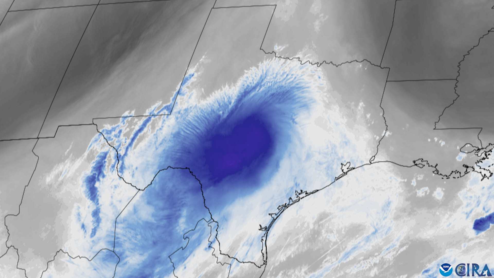
Late on July 3, a mid-level atmospheric trough over the Southwest, already laden with tropical Pacific moisture, spawned thunderstorms that stalled directly over Central Texas. The National Weather Service issued a flood watch that afternoon and began escalating warnings through the night. By 5:34 a.m. on July 4, a flash flood emergency warned of "a large and deadly flood wave moving down the Guadalupe River." At Hunt, where the river's two branches converge, gauges recorded the water surging past major flood stage before failing entirely. Downstream at Kerrville, the river rose at a rate that left no time to react. At Comfort, it climbed nearly as fast. Camp Mystic, a Christian girls' summer camp hosting 750 campers on the river's banks, was devastated -- 27 campers and counselors died, including camp director Dick Eastland, who had owned the camp since 1974. Over 12,100 structures were damaged across the region.
A Nation Responds
Search and rescue operations began on July 4, with 237 people pulled from floodwaters by day's end -- 167 of them lifted from trees and rooftops by helicopter. Over 2,000 volunteers descended on Kerr County. Task forces arrived from across the country: Arkansas National Guard helicopters, Colorado's 48-member team with search canines, Navy SEALs volunteering in groups of thirty, and North Dakota's MQ-9 Reaper drone remotely piloted from Fargo to survey inaccessible terrain. NASA deployed two aircraft. By July 8, more than 440 people had been rescued and 120 bodies recovered. The Community Foundation of the Texas Hill Country raised $30 million for relief within the first week.
Warnings That Never Came
The flood exposed years of missed chances to build a warning system in Kerr County. After the 1987 floods, Camp Mystic's owner proposed an automatic alert system, which was eventually installed. A third-party contractor managed it until going out of business in 1998; the river authority decommissioned it in 1999. In 2016, the county sheriff advocated for sirens, but a commissioner dismissed the idea as "a little extravagant." Grant requests to the Texas Division of Emergency Management in 2017 and 2018 for upgraded water gauges were denied. Federal pandemic relief funding from the American Rescue Plan Act of 2021 could have been used for flood monitoring, but local opposition -- partly driven by fears of federal mandates -- prevented it. Kerr County relied on cellphone emergency alerts, useless for the Camp Mystic girls, who were not allowed to bring phones. Meanwhile, neighboring Comal County had completed a dedicated flood siren system in 2015.
Reckoning on the Guadalupe
The disaster forced a reckoning on multiple fronts. FEMA's flood maps came under scrutiny: Camp Mystic had at least eight buildings inside a designated floodway, yet between 2011 and 2020, the agency had redrawn the 100-year flood boundary multiple times following camp appeals, removing roughly 30 buildings from the official hazard area. Questions about federal response capacity also surfaced, with reports that a new policy requiring the Secretary of Homeland Security's personal approval for contracts over $100,000 delayed the pre-positioning of Urban Search and Rescue teams by more than 72 hours. Texas Governor Greg Abbott signed a state disaster declaration; President Trump issued a federal one for Kerr County. As the waters receded, the death toll settled at 135, with two people still missing months later. The limestone hills of Flash Flood Alley, beautiful and treacherous in equal measure, had extracted their toll once again.
From the Air
Centered near 30.04N, 99.23W in the Texas Hill Country, along the Guadalupe River corridor through Kerr County. The nearest airports include Kerrville Municipal Airport (KERV) and San Angelo Regional / Mathis Field (KSJT). The flood zone stretches from Hunt through Kerrville to Comfort and downstream. The terrain is characterized by steep limestone hills, narrow river valleys, and cypress-lined waterways. From the air, the Guadalupe River's winding course through the Hill Country is clearly visible, with flood scars and debris fields potentially still evident along the banks. Best viewed at 2,000-5,000 feet AGL.
Sources
- Wikipedia - July 2025 Central Texas floods
- Texas Tribune - Texas identifies 119 killed in Kerr County
- NPR - FEMA removed Camp Mystic buildings from flood map
- MDPI Water Journal - Vehicle-Related Flood Fatalities in Texas 1959-2019
- Wikipedia - 1976 Big Thompson River flood
- NWS - 1987 Guadalupe River Flood
- Wikipedia - October 1998 Central Texas floods