Juneau: The Capital That No Road Can Reach
Juneau is the only American state capital unreachable by road. The mountains that surround it, the glaciers that calve into its waters, and the fjords that define its geography make highway construction prohibitively expensive - or perhaps impossible. Legislators fly in; cruise ships disgorge tourists; supplies arrive by barge. The isolation is extreme by Lower 48 standards but normal for Southeast Alaska, where every community is similarly water-bound. Gold made Juneau; the Treadwell and Alaska-Juneau mines once produced more gold than California during the rush. The capital moved here from Sitka in 1906, and Alaskans have debated moving it ever since. But Juneau persists - small, isolated, spectacularly located, and continuously threatened by proposals to relocate governance to somewhere more accessible.
The Gold
Joe Juneau and Richard Harris followed Tlingit guidance to gold in 1880, founding the camp that became Alaska's first major mining town. The Treadwell Mine on Douglas Island became one of the world's largest gold mines; the Alaska-Juneau Mine extracted ore from mountains that rose directly from the water. Juneau boomed while other gold rush towns faded, the ore body persistent where placer gold was quickly exhausted elsewhere. The mines closed by the 1940s - wars and economics, not exhaustion - but Juneau had established itself. The capital designation, transferred from Sitka in 1906, ensured survival even after mining ended. Government employment replaced gold; the city's purpose shifted but its existence was secured.
The Glacier
The Mendenhall Glacier extends from the Juneau Icefield to within twelve miles of downtown - one of the world's most accessible glaciers, visible from the road, approached by trails to the visitor center. The glacier has retreated dramatically in recent decades; what visitors see now was covered by ice within living memory. Nugget Falls cascades beside the glacier's face; icebergs calve into Mendenhall Lake. The Juneau Icefield, source of Mendenhall and thirty-seven other glaciers, covers 1,500 square miles behind the capital. The ice is receding, the climate changing, and Juneau watches from its precarious position between water and ice.
The Access
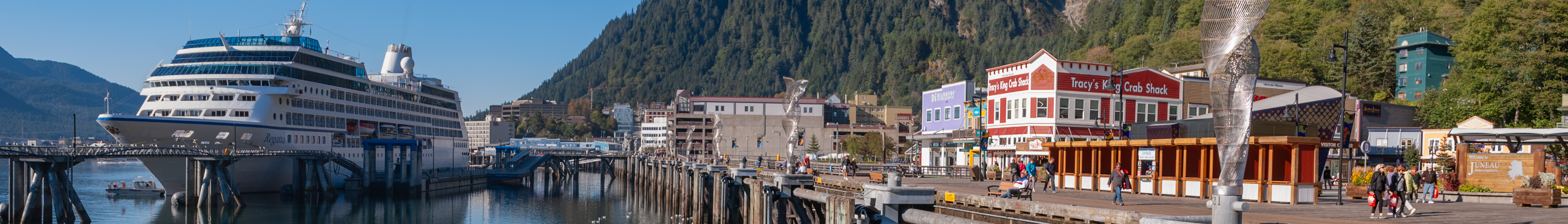
No highway connects Juneau to anywhere. The Alaska Marine Highway provides ferry service - a voyage of hours or days depending on origin. Jets land at an airport wedged between mountains and water, approaches challenging enough that delays are common. Floatplanes provide alternative access, landing in the channel. The isolation creates expense: everything from groceries to construction materials arrives by barge. Proposals to build a road surface periodically - across glaciers, through wilderness, connecting to the sparse road network of Southeast Alaska - but costs reach billions and benefits remain uncertain. The capital remains an island, connected to Alaska by water and air alone.
The Capital Question
Alaskans have voted repeatedly on moving the capital. Willow, north of Anchorage, won a 1976 vote; the move was never funded. Subsequent proposals have failed. Juneau's isolation frustrates citizens who must travel far to access their government; Juneau's establishment fights relocation that would devastate the local economy. The debate resurfaces each session: legislators complaining about travel, constituents complaining about accessibility, nobody willing to fund the billions a move would require. Juneau remains the capital by inertia as much as choice, the isolation that defines it also protecting it from the displacement that accessibility would enable.
Visiting Juneau
Juneau is accessible by Alaska Airlines from Seattle and Anchorage, or by Alaska Marine Highway from Bellingham, Washington, and various Alaska ports. Cruise ships dominate summer traffic, bringing thousands of passengers daily to a downtown built for far fewer. The Mendenhall Glacier Visitor Center is twelve miles from downtown; buses and tours provide access. The Mount Roberts Tramway offers views over the channel. Whale watching is reliable; humpbacks feed throughout the area. The Alaska State Museum interprets Indigenous cultures and state history. Downtown is walkable; venturing beyond requires vehicle rental or tours. The experience combines accessible wilderness with small-town capital, icefields with government buildings, isolation with surprising cultural depth.
From the Air
Located at 58.30°N, 134.42°W on the Gastineau Channel in Southeast Alaska. From altitude, Juneau appears as a narrow strip of development squeezed between the channel and the mountains that rise directly behind it. The Mendenhall Glacier flows from the Juneau Icefield toward the sea, terminating in a lake visible from the air. The airport's single runway extends into the channel on fill. Douglas Island lies across the water. Cruise ships appear as large vessels at the downtown docks. The road system is visible but goes nowhere - dead-ending in both directions against wilderness. What appears from altitude as an improbably located small city is the only American state capital unreachable by road - government by floatplane, supplies by barge, isolation as identity.