Juruena National Park
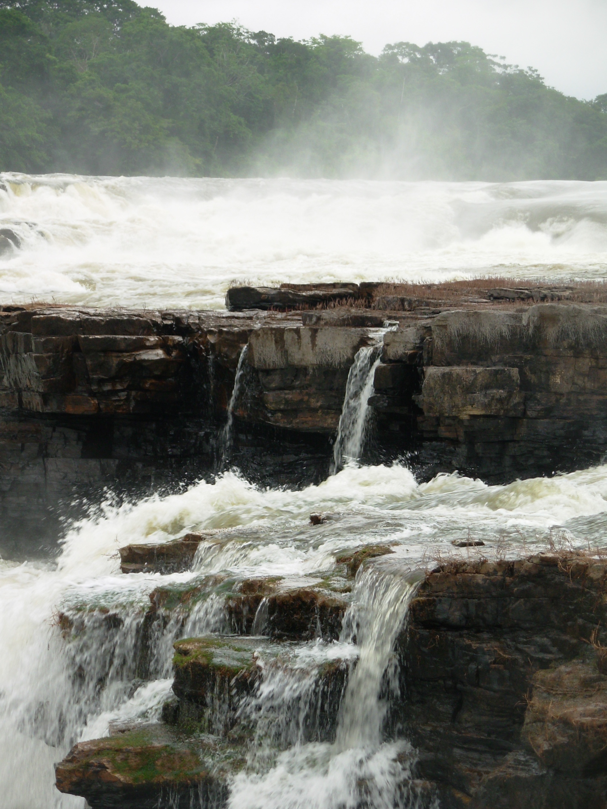
The rivers give the first warning that navigation is unwelcome. Green in the dry season and muddy during the rains, the waterways of Juruena National Park are choked with rocky outcrops, rapids of every size, and waterfalls that have been reshaping stone since long before humans reached the Amazon. At nearly two million hectares, Juruena is Brazil's third-largest national park, and its terrain seems designed to resist easy access -- forty-nine percent flat plains, yes, but the rest undulates upward through increasingly rugged country, with altitudes ranging from 39 meters to peaks that rise well above. This is not a park that invites casual visitors. It is a fortress of forest, river, and stone, holding one of the most biologically significant corridors on the continent.
Thirty-Nine Basins Under One Canopy
Juruena contains thirty-nine river sub-basins, each feeding into the Juruena River that gives the park its name. The largest belongs to the Sao Tome River, which occupies twenty-three percent of the park's area and has every one of its sources contained within the boundaries. The Sucunduri River basin covers another ten percent in the north. These clear-water rivers -- classified by their transparency, not their color -- shift between olive-green and outright turbid depending on the season. What they share is a stubborn resistance to boats. Rocky outcrops and rapids make navigation poor for vessels of any size, which has the unintended benefit of keeping the interior remote. The park sprawls across five municipalities: Apui and Maues in Amazonas, and Cotriguacu, Nova Bandeirantes, and Apiacas in Mato Grosso. To the west, it adjoins the 808,312-hectare Sucunduri State Park, and the Igarapes do Juruena State Park overlaps more than half its area.
The Ecological Corridor
Juruena was not created in isolation. Declared by decree on June 5, 2006, under the Amazon Region Protected Areas Programme launched in 2002, it forms one link in an ecological corridor that stretches across the heart of Brazil. The chain runs from the Xingu Indigenous Park in Mato Grosso and Para, through the Terra do Meio Mosaic in Para, to Juruena itself, then onward through the Apui Mosaic in Amazonas and finally to the Campos Amazonicos National Park in Amazonas and Roraima. The corridor's purpose is unambiguous: to contain agricultural expansion into the central Amazon. Soy fields and cattle ranches push northward from Mato Grosso, consuming forest at a pace that alarms conservationists. Juruena, administered by the Chico Mendes Institute for Biodiversity Conservation, sits squarely in the path of that advance, a biological barrier spanning the Tapajos and Madeira river basins.
Wings, Calls, and Endemic Lives
Researchers have identified 412 bird species within the park, forty of which are endemic to the southern Amazon and at least twenty-six restricted to the corridor between the Madeira and Tapajos rivers. The bald parrot, with its vivid orange crown, is found almost nowhere else. The bare-eyed antbird skulks through the understory. Snow-capped manakins perform their courtship displays in the mid-canopy, while Gould's toucanets flash through gaps in the foliage. Dark-winged trumpeters call from the forest floor, and crimson-bellied parakeets streak between fruiting trees. Migratory species add seasonal layers: purple martins arriving from North America, barn swallows that have crossed an ocean, fork-tailed flycatchers riding the thermals. Below the canopy, the ashy black titi -- a primate endemic to this region -- moves through the branches. In the rivers, migratory fish species navigate the rapids on journeys that connect Juruena's waters to the broader Amazon network.
The Dams That Didn't Come
In 2014, the stakes sharpened. The federal government proposed building two hydroelectric dams -- Sao Simao Alto and Salto Augusto Baixo -- within the park, with a combined capacity of 4,940 megawatts. The reservoirs would have drowned more than 40,000 hectares, flooding portions of Juruena, the Igarapes do Juruena State Park, and the Escondido and Apiaka do Pontal indigenous territories in Mato Grosso, while damaging the Sucunduri State Park in Amazonas. The waterfalls at Salto Augusto and San Simon -- the very features the park was created to protect -- would have vanished beneath still water. WWF-Brasil organized the opposition. The National Council for Energy Policy, which should have included civil society voices, had left its two designated seats unfilled. Public pressure mounted. In September 2014, the government withdrew its proposal. The waterfalls kept falling. But the episode revealed how quickly protection can be reversed when energy demand collides with conservation mandates.
From the Air
Located at 7.87S, 58.14W, straddling the border between Amazonas and Mato Grosso states, Brazil. The Juruena River is the primary visual landmark -- a winding corridor through unbroken canopy. Look for the dramatic waterfalls at Salto Augusto and San Simon along the river. The park is enormous, spanning nearly two million hectares. Nearest airports: Jacareacanga (SBEK) to the northwest, Apui (SWBC) to the west, and Juina (SWJN) in Mato Grosso to the south. Manaus (SBEG) is approximately 500 km north. Recommended viewing altitude: FL380 or above for the full extent; 3,000-5,000 feet for waterfall and rapids detail.