Ka'ula
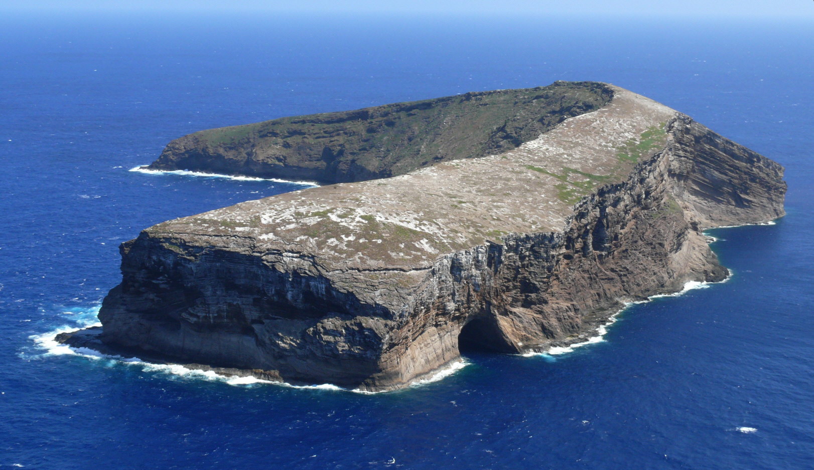
Twenty-two miles southwest of Ni'ihau -- itself the most restricted of Hawaii's main islands -- a crescent of volcanic rock rises from the Pacific like a broken tooth. Ka'ula is barely 158 acres of tuff and basalt, and it is getting smaller. The ocean is eating it. Waves have carved sheer sea cliffs into its flanks and hollowed out Kahalauaola, the Shark Cave, on its northwest face. In Hawaiian mythology, Ka'ula is the seventh-born child of Papa and Wakea, the earth mother and sky father who created the islands. The U.S. Navy uses it for bombing practice.
A Volcanic Remnant at the Edge of the Chain
Ka'ula is the exposed summit of a volcanic tuff cone perched atop a much larger submerged shield volcano. At its highest point, the island reaches 548 feet above sea level -- respectable height for so small a footprint, giving the island the profile of a steep fortress when approached by sea. Captain James Cook was among the first Europeans to sight it, recording the island as "Tahoora" when he reached the Hawaiian chain in 1778. It was one of the first five islands his expedition identified. Today Ka'ula sits about 150 nautical miles west of Honolulu, administratively part of Kauai County, though no one lives there and no one has for a very long time.
Light, Then Darkness
For fifteen years, Ka'ula had a lighthouse. The United States Lighthouse Service completed the structure in 1932, perching a beacon on this remote speck of land to guide ships through the western Hawaiian waters. When the Lighthouse Service was absorbed into the Coast Guard in 1939, the light continued to operate. By 1947, it went dark. The automated navigation systems that were replacing lighthouses across the Pacific made Ka'ula's beacon redundant. The structure remains, but no light has shone from it in nearly eighty years. It stands as a monument to a brief era when someone thought this island mattered enough to illuminate.
Sanctuary and Target Range
Ka'ula's dual identity is almost absurd. In 1978, over the objections of the U.S. Navy, the state of Hawaii claimed ownership of the island and designated it a State Seabird Sanctuary. The island hosts significant nesting colonies, and its isolation makes it ideal habitat. The Navy, however, has used Ka'ula as a bombing range since at least 1952. While inert ordnance is now standard, live explosives were used in the past, and the risk of unexploded ordnance remains. Permission from the Navy is required to set foot on the island. The question of who actually owns Ka'ula -- Hawaii or the federal government -- has never been definitively resolved. So the seabirds nest on an island that the military intermittently bombs, and both sides claim jurisdiction over the crescent of rock that neither truly occupies.
Beneath the Surface
While no one lives on Ka'ula, people visit the waters around it regularly. Fishermen work the surrounding reefs, and scuba divers are drawn to the island's dramatic underwater terrain. Three miles west-northwest of Ka'ula lies Five Fathom Pinnacle, a submerged seamount that rises close enough to the surface to create an oasis of marine life in the open ocean. Hawaiian monk seals haul out in the area, and the clarity of the water this far from developed coastline makes for exceptional visibility. The diving here is remote and demanding -- there are no harbors, no services, no shelter if weather turns -- but for those willing to make the journey from Ni'ihau or Kauai, the reward is an underwater landscape shaped by the same volcanic forces that built Ka'ula itself, untouched by the development that has transformed the main Hawaiian islands.
From the Air
Ka'ula is located at approximately 21.65N, 160.54W, roughly 22 miles southwest of Ni'ihau and 150 nautical miles west of Honolulu. From the air, the island appears as a small crescent-shaped rock formation with steep sea cliffs, distinctly visible against the deep blue Pacific. The nearest airports are Lihue Airport (PHLI) on Kauai, about 75 nautical miles to the east-northeast, and Barking Sands Pacific Missile Range Facility (PHBK) on Kauai's west side, somewhat closer. Pilots should be aware that the island is an active military bombing range -- check NOTAMs for restricted airspace.