Kabul-Kandahar Highway
Every nation has a road that tells its story. For Afghanistan, that road is the Kabul-Kandahar Highway, NH0101 -- roughly 480 kilometers of asphalt connecting the capital to the country's second city through some of the most contested terrain on earth. American engineers paved it in the 1960s as Cold War diplomacy. Soviet convoys rolled down it in the 1980s as occupation. By the 1990s it had crumbled to rubble. In 2003 the Americans rebuilt it for $190 million. And through every era, the people who depend on it most -- the bus drivers, truckers, and travelers who have no other viable route between Afghanistan's population centers -- have paid the highest price for its existence.
A Highway Born of Rivalry
The Kabul-Kandahar Highway was designed and asphalted in the 1960s by Afghan and American engineers working under the U.S. International Cooperation Administration, during a period when both Washington and Moscow were competing for influence in Afghanistan through infrastructure projects. The Soviets built roads in the north; the Americans built in the south. Prime Minister Mohammad Daoud Khan presided over the highway's opening ceremony. In those years, the road carried mostly trucks and coach buses -- private cars were rare. The highway functioned as Afghanistan's commercial spine, threading through Maidan Shar, Ghazni, and Qalat before reaching Kandahar. Then the Soviets invaded. Through the 1980s, military convoys rumbled between the two cities, and by the time the civil wars of the 1990s had run their course, the pavement had disintegrated.
Reconstruction Under Fire
In September 2002, under the new government of Hamid Karzai, the United States funded the highway's reconstruction at a cost of approximately $190 million, with Japan funding additional sections. The Louis Berger Group, a New Jersey-based firm, won the contract and completed the work with Afghan-American, Turkish, and Indian subcontractors. Phase one of paving was finished by December 2003, and the reopened highway was celebrated as proof that reconstruction was possible. But the Taliban had not conceded the road. As early as 2004, fighters harassed travelers along the corridor. In October 2003, they kidnapped a Turkish contractor; in December, two Indian workers. In February 2004, Taliban rebels shot down a Louis Berger Group helicopter, killing three. A month later, they murdered a Turkish engineer and an Afghan guard. The U.S. responded by establishing small civilian-military teams at three points along the route.
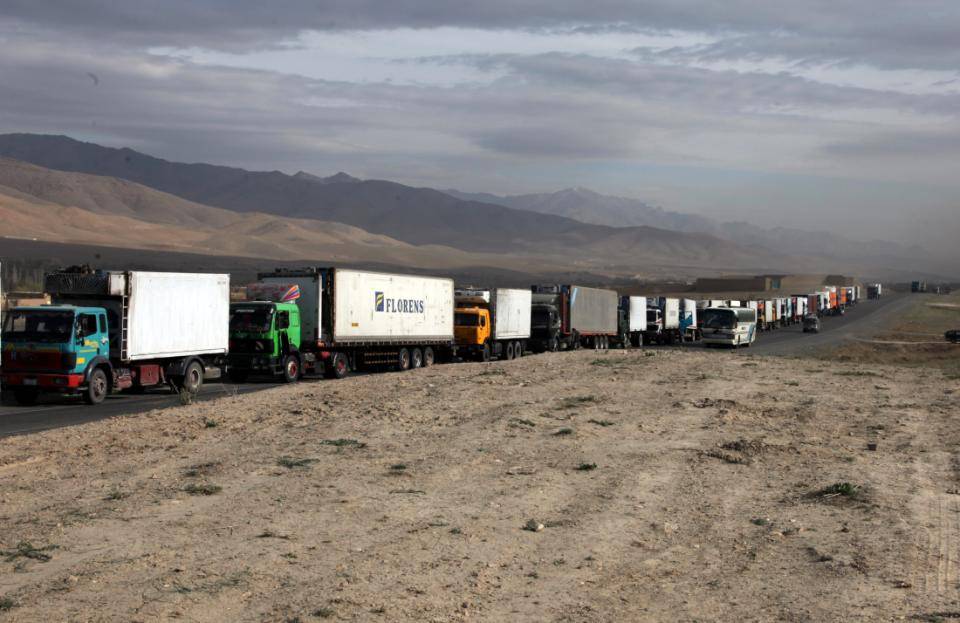
Five Provinces, One Lifeline
The highway starts from Dashte Barchi in western Kabul and traverses five provinces: Kabul, Maidan Wardak, Ghazni, Zabul, and Kandahar. Major intersections branch off to provincial capitals -- Puli Alam in Logar, Gardez in Paktia -- making NH0101 the trunk from which much of southeastern Afghanistan's road network grows. It forms a key section of the Afghanistan Ring Road, the national highway system designed to connect the country's major cities in a loop. Between the major intersections, smaller roads branch off to villages and districts, and five truck scales regulate commercial traffic across the provinces. For millions of Afghans, there is no alternative to this road. It is the route to medical care, to markets, to family.
The Price of Speed
The highway's death toll comes not only from conflict. Head-on collisions between overloaded buses and fuel tankers have produced some of Afghanistan's worst traffic disasters. On May 8, 2016, two buses traveling from Kabul to Kandahar collided with a fuel tanker in Ghazni Province's Moqor District, killing at least 73 people and injuring over 50 in a fiery explosion. The buses had reportedly been speeding to minimize their time in Taliban territory -- a cruel irony in which the fear of one danger drove travelers into another. In September 2016, a tanker-bus collision in Zabul Province killed at least 38. On December 18, 2024, two separate highway crashes in Ghazni killed 50 people and injured 76. The road that connects Afghanistan also claims it.
Rebuilding Again
In 2022, the current government began converting sections of the highway into a modern divided road to reduce the head-on collisions that have become endemic. Construction of temporary toll plazas started in Kabul Province, with another planned for Kandahar. By 2025, work had begun on major bus terminals -- one in the Arghandi area of Kabul Province and another in the Daman District of Kandahar -- projects expected to take three years. The Dashte Barchi bus station already serves as a hub for routes to Maidan Wardak, Bamyan, Ghazni, Daikundi, and Ghor provinces. After six decades of construction, destruction, and reconstruction, the highway remains what it has always been: the road Afghanistan cannot do without, no matter the cost of traveling it.
From the Air
Located at approximately 32.11N, 66.05E, the highway stretches roughly 480 km between Kabul (OAKB) and Kandahar (OAKN). From altitude, the road is visible as a thin line of asphalt crossing brown desert and passing through the cities of Maidan Shar, Ghazni, and Qalat. The highway traverses five provinces and follows relatively flat terrain between mountain ranges. Ghazni airfield (OAGN) sits along the route. The road is part of Afghanistan's Ring Road (National Highway 1) and is the country's primary north-south commercial corridor.