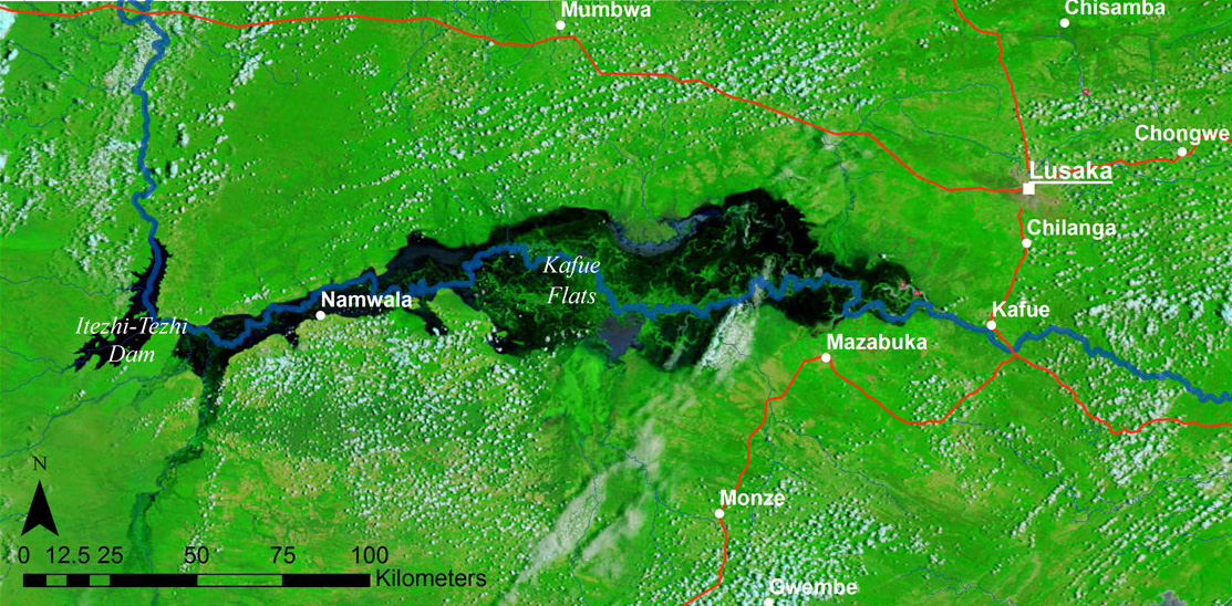
Kafue Flats
In 1931, an estimated 250,000 Kafue lechwe grazed the Kafue Flats -- one of the highest animal carrying capacities recorded anywhere on Earth. The flats, known locally as Butwa, are a shallow floodplain stretching east to west along the Kafue River through three of Zambia's provinces. In the rainy season, water spreads across the plain to a depth of less than a meter, transforming it into a labyrinth of swamp, open lagoon, and flooded grassland. In the dry season, the water retreats, leaving heavy black clay that cracks wide enough to swallow a boot. This annual pulse of flood and drought has shaped everything that lives here -- until the dams changed the rhythm.
The First People of Butwa
The Batwa, or Twa, are thought to have been the first inhabitants of the Kafue Flats, descendants of the nomadic hunter-gatherers who occupied Zambia long before Bantu-speaking peoples arrived from the Congo Basin to the north. Today the Batwa are a small minority, settled on higher ground along the Kafue River channel, supporting themselves through fishing. The Ila and Balundwe farmers and cattle herders who now dominate the flats arrived between two and three hundred years ago, establishing at least 21 chieftaincies. Their lives followed the water: fixed settlements in the woodlands during the flood season, then cattle camps on the drying flats after the waters receded. Seasonal fishing communities from the Bemba in the north and the Lozi from the west add to the mix. The Batwa, however, face marginalization from some of these groups -- a painful irony for the people who were here first.
A Wetland Reshaped
Before the Itezhi-Tezhi Dam was built upstream, the Kafue Flats followed a predictable annual cycle. River levels began rising with the November-December rains, peaked between April and May, then slowly drained until almost no surface water remained by October. The dam, built to store water for the Kafue Gorge power station downstream, replaced that smooth rise and fall with sudden surges as large volumes were released for electricity generation. A substantial flow now runs through the dry season -- the opposite of the natural pattern. Parts of the flats, such as Chunga Lagoon, remain permanently flooded. At the eastern end, the Kafue Gorge Dam's reservoir backs water into the flats, creating additional zones of permanent inundation. The ancient rhythm that wildlife, vegetation, and human communities evolved around has been rewritten to serve a turbine schedule.
Cranes, Lechwe, and Vultures
The ecological consequences have been severe. The Kafue lechwe, an antelope subspecies found nowhere else, declined from that quarter-million in 1931 to dramatically lower numbers -- victims of altered flooding, illegal poaching, and pressure from expanding human and cattle populations. The wattled crane, listed as vulnerable on the IUCN Red List, dropped from between 2,000 and 3,000 in the 1970s to fewer than 1,000 by 2002. Lochinvar National Park, on the southern edge, still harbors one of Africa's highest concentrations of this species. Blue Lagoon National Park, to the north, shelters lechwe, sitatunga, zebra, and African buffalo alongside large flocks of waterbirds. The flats host significant breeding colonies of raptors, particularly vultures, deep within the swamps. Crowned cranes, slaty egrets, lappet-faced vultures, lesser kestrels, and corn crakes all depend on this ecosystem. In 1991, the Kafue Flats were added to the Ramsar list of Wetlands of International Importance, a recognition that their value extends far beyond Zambia's borders.
Sugar, Wheat, and Six Thousand Square Kilometers
Agriculture has claimed the margins of the flats. The Nakambala Sugar Estate at Mazabuka, owned by Zambia Sugar (a subsidiary of South Africa's Illovo Sugar), is the country's largest sugar producer, operating on approximately 15,000 hectares of irrigated land. North of the river, Consolidated Farming produces sugar under the Kafue Sugar brand from a 9,000-hectare estate. The Chiansi irrigation scheme grows wheat and other crops on a smaller scale with plans to expand. Beyond the commercial farms, thousands of subsistence and small-scale farmers depend on the flats for their livelihoods. By 2004, at least eleven major permanent fishing camps operated on the flats, each occupied by at least 500 fishermen, with many more temporary camps established in the dry season. Six thousand square kilometers outside the national parks are covered by the Kafue Flats Game Management Area, which attempts to balance environmental protection with sustainable resource use.
The Cracking Earth
The soils themselves tell the story of the flats' extremes. Heavy in texture, mainly black or dark gray, they crack wide open in the dry season and become sticky and plastic when wet. The surface forms a distinctive pattern called gilgai -- small ridges standing 20 to 60 centimeters above circular depressions two to seven meters across, a landscape that looks corrugated from the air. Two ecoregions converge here: the Zambezian flooded grasslands at the center and the Zambezian and mopane woodlands around the edges. It is this convergence -- floodplain meeting woodland, seasonal water meeting permanent swamp -- that created one of southern Africa's most productive ecosystems. Whether that productivity can survive the compound pressures of hydroelectric demand, agricultural expansion, invasive weeds, and a growing population remains an open question. The lechwe and the cranes cannot negotiate with turbine operators.
From the Air
The Kafue Flats center around 15.63S, 27.07E, stretching roughly east-west along the Kafue River in Zambia. From 5,000-10,000 feet AGL, the flats are unmistakable: a vast, flat expanse of seasonal wetland visible as green flooded grassland in the wet season or cracked dark earth in the dry. The Itezhi-Tezhi Dam is visible at the western end, and the Kafue Gorge at the eastern end. Lochinvar National Park lies along the southern edge. Lusaka (FLLS) is approximately 130 km to the northeast. Mazabuka and its sugar estates are visible on the southeastern margin. Expect haze in the dry season and towering cumulonimbus in the wet.