Kaikoura
In Maori, kai means eat and koura means crayfish. The name is not subtle, and neither is the town. Kaikoura sits on a narrow coastal plain on the South Island's east coast, hemmed in by mountains so steep they occasionally drop straight into the sea, leaving barely enough room for a railway line, a two-lane road, and a strip of rocky beach. Just offshore, the continental shelf plunges into the Hikurangi Trench, and the deep water it brings close to land draws sperm whales, dolphins, fur seals, and 13 species of albatross to a stretch of coast that might hold more marine biodiversity per kilometre than anywhere else in New Zealand.
Maui's Foothold
Maori settled Kaikoura long before European ships appeared on the horizon, cultivating the coastal plain with kumara, a type of sweet potato suited to the mild climate. According to Maori legend, the demigod Maui stood on the Kaikoura Peninsula to steady himself as he hauled the North Island from the sea, a story that speaks to how this finger of land feels even now: solid, rooted, the kind of place you plant your feet. Captain James Cook sighted the peninsula in 1770, initially mistaking it for an island. European settlers established a whaling station here in 1842, and the remains of the blubber-rendering pots can still be seen on the town foreshore. The whales are still here too, though the relationship has changed. Today Kaikoura is one of the best places on Earth to watch them.
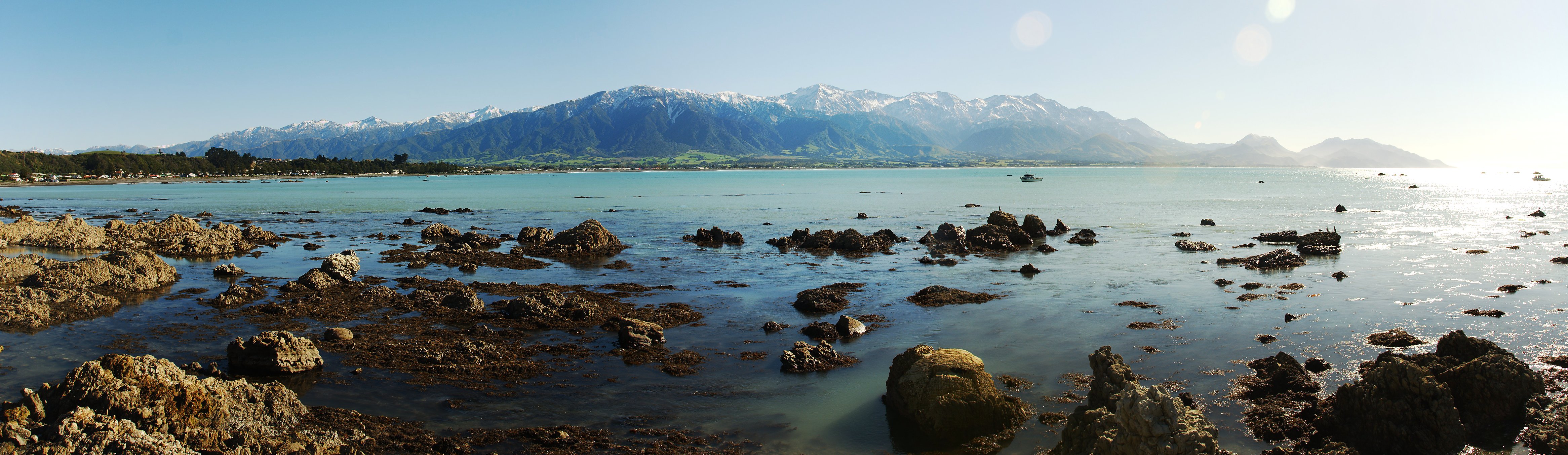
The Mountain Meets the Sea
The geography around Kaikoura is almost unreasonably dramatic. The Seaward Kaikoura Range rises to over 2,600 metres just inland, its snow-capped peaks visible from the beach on clear days. The Inland Kaikoura Range stands even taller behind it. Between these walls of rock and the Pacific, the town occupies a sliver of flat ground on the peninsula and the narrow coastal plain. In places along State Highway 1, tunnels are needed where the mountains crowd the road to the water's edge. This compression of landscape is not just scenic; it is geological. The steepness of the mountains mirrors the steepness below the surface, where the Hikurangi Trench and the continental shelf edge lie just offshore, creating the deep-water conditions that make the ocean here so rich with life.
A Living Ocean
The marine life around Kaikoura is staggering in its variety. Sperm whales are the headline act, their dark shapes surfacing year-round in the deep water south of the peninsula. But they share these waters with dusky dolphins, New Zealand fur seals hauled out on the rocks, and the occasional visiting orca. Depending on the season, humpback whales, pilot whales, blue whales, and southern right whales pass through on their migrations. Kaikoura is home to Hector's dolphin, the world's smallest and rarest dolphin species, and attracts the largest concentration of seabirds on mainland New Zealand, including 14 varieties of petrels, 7 types of shearwater, and the wandering albatross with its three-metre wingspan. Whale Watch Kaikoura operates from a station on Whaleway Station Road, and the name captures the town's easy relationship with the ocean that sustains it.
Shaken and Rebuilt
On 14 November 2016, a magnitude 7.8 earthquake ruptured multiple faults beneath the region, cutting Kaikoura off from the rest of New Zealand. State Highway 1 was buried by landslides. The railway was severed. For days, the town was accessible only by sea and air. The earthquake raised the seabed along the coast by as much as six metres, killing marine life in the intertidal zone and reshaping the shoreline. Recovery took years. The highway north of town did not fully reopen until December 2017, and the final road and rail rebuild was not completed until 2020 at a cost of NZ$1.25 billion. But Kaikoura's resilience proved as stubborn as its geography. Tourism returned. The whales never left. And the town continues to do what its name has always promised: feed you well from the sea.
The Journey In
Getting to Kaikoura is part of the experience. The Coastal Pacific train, running between Picton and Christchurch from October through April, follows the coastline for the final stretch into town with mountains on one side and the Pacific on the other. Fur seals lounge on rocks beside the tracks. By car, Kaikoura sits on State Highway 1, two and a half hours north of Christchurch and an hour and forty minutes south of Blenheim. The more adventurous inland route, Route 70, branches off State Highway 7 north of Culverden and passes through high country that feels a world away from the coast. Kaikoura also forms one corner of the Alpine Pacific Triangle touring route, a 370-kilometre loop linking the town with Hanmer Springs and the Waipara Valley wine region.
From the Air
Kaikoura township sits at 42.42S, 173.68E on the east coast of New Zealand's South Island. The Kaikoura Peninsula extends prominently into the Pacific, easily identifiable from the air. The Seaward Kaikoura Range rises dramatically to the west, snow-capped for much of the year. Look for the narrow coastal strip where SH1 threads between mountains and ocean. Kaikoura Aerodrome (NZKK) lies just south of town. Christchurch International (NZCH) is approximately 180 km to the south-west. Blenheim/Woodbourne (NZWB) is about 130 km to the north. Best viewing at 3,000-5,000 feet AGL to take in the full contrast of mountains, coast, and deep ocean.