Kainji Dam
One quarter of the money spent building Kainji Dam went not to concrete or turbines but to moving people out of the way. That ratio tells you something about what it means to dam the Niger River in central Nigeria, where the line between infrastructure and displacement has never been cleanly drawn. Completed in 1968 after four years of construction by the Italian consortium Impregilo, Kainji Dam stretches ten kilometers across the river and its tributary valleys in Niger State, creating a reservoir 135 kilometers long. It was designed to electrify a nation. It has also, on more than one occasion, flooded one.
An Italian Blueprint on African Water
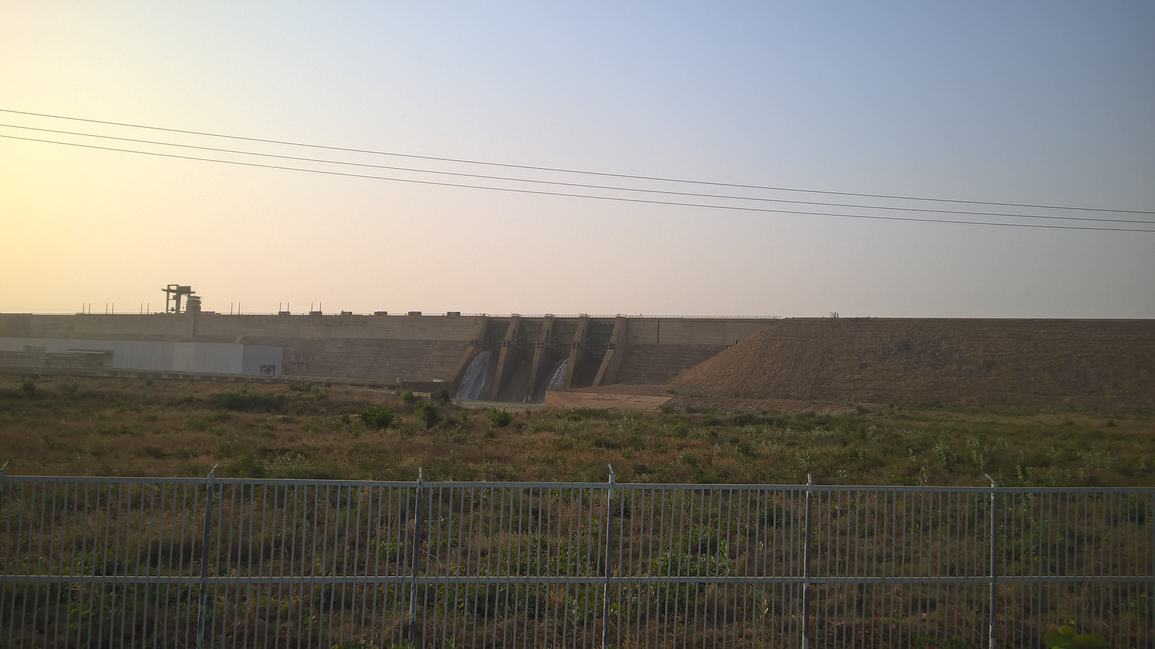
The dam's dimensions are imposing but deceptive. Most of those ten kilometers are earth embankment, including a saddle dam that seals off a tributary valley. The concrete heart of the structure, where the hydroelectric turbines sit, rises 65 meters above the riverbed and spans 550 meters across the Niger's main channel. The original design called for twelve turbines generating 960 megawatts, enough to light every major city in Nigeria and sell surplus power across the border to Niger. But only eight turbines were ever installed, capping capacity at 760 megawatts. The dam cost an estimated 209 million US dollars, a figure that in today's terms reaches into the billions. A single lock chamber lifts barges 49 meters, connecting river traffic above and below the dam, though the lock sees far less commercial use than its builders envisioned.
The Lake That Swallowed Towns
Behind the dam, Kainji Lake sprawls across the landscape, roughly 135 kilometers long and 30 kilometers wide at its broadest point. The reservoir supports irrigation and a fishing industry that feeds communities along its shores. But the lake's creation required the resettlement of entire populations, an upheaval that consumed a quarter of the project's total budget. Villages vanished beneath rising water. The town of Old Bussa, historically significant as the place where the Scottish explorer Mungo Park died in 1806, now lies submerged. New Bussa was built on higher ground to replace it, a planned settlement that inherited the name but not the history of its predecessor.
When the Floodgates Open
Twice in consecutive years, Kainji Dam demonstrated its capacity for destruction. In October 1998, upstream flooding forced operators to release a torrent of water that burst the Niger's banks downstream. Nearly sixty villages were inundated. Livestock drowned, dikes collapsed, and farms were swept away. Officials faced sharp criticism for waiting too long to begin controlled releases and then dumping too much water at once. The following year, in 1999, uncoordinated opening of floodgates caused flooding of roughly the same scale, devastating another sixty villages. The pattern revealed a fundamental tension at the heart of the project: a dam built to harness the Niger's power must also contend with the river's unpredictability, and the communities downstream bear the cost of every miscalculation.
Power and Drought
The Niger River does not flow with the reliability that turbine engineers prefer. Periodic droughts reduce the river's volume, diminishing the dam's electrical output at precisely the moments when Nigeria's growing cities demand more power. The gap between the dam's designed capacity and its actual performance reflects a broader challenge across West African hydropower: climate variability makes the river an unreliable partner. Despite these limitations, Kainji Dam remains a cornerstone of Nigeria's power grid, generating electricity for the country's largest cities and exporting power to neighboring Niger. Zebu cattle still cross the dam's roadway, shepherds guiding them past the same concrete openings where water roars through the turbines below.
From the Air
Located at 9.86N, 4.61E in Niger State, Nigeria. The dam and its 135km reservoir are prominent features visible from altitude. The dam structure itself stretches 10km and is clearly visible on approach. Nearest airports include Minna Airport (DNMN) approximately 200km to the east and Ilorin International Airport (DNIL) to the south. The reservoir, Kainji Lake, is a major navigation landmark along the Niger River. Best viewed at 5,000-10,000 feet for the full scale of the dam and lake.