Kalaupapa, Hawaii
The zip code still works. That is one of the stranger facts about Kalaupapa, a community on the north coast of Molokai where the post office continues to operate for a population that has dwindled to fewer than a hundred people. For more than a century, this flat peninsula at the base of cliffs rising 2,000 feet above the Pacific was a place of forced exile, where the Hawaiian government sent anyone diagnosed with leprosy and declared them legally dead. At its peak, about 1,200 people lived here against their will. Today, a handful of former patients remain by choice, growing old in a place the rest of Hawaii has agreed to leave mostly undisturbed.
Carved by Catastrophe
The Kalaupapa Peninsula exists because of volcanic violence. Between 230,000 and 300,000 years ago, an undersea volcano called Pu'u 'Uao erupted from the ocean floor near Molokai's north coast. The lava spread outward, cooling into a low shield that became the peninsula. Behind it, the sea cliffs that isolate Kalaupapa from the rest of the island were not carved by ordinary erosion. Geologists now believe they formed when a third of the northern portion of Molokai collapsed into the sea about 1.5 million years ago. The offshore islands of Okala, Mokapu, and Huelo are remnants of the original landmass, still harboring native plant species like the rare loulu palm that grew on Molokai over two thousand years ago. At the peninsula's center sits Kauhako Crater, whose lake holds the greatest depth-to-surface-area ratio of any lake on Earth.
A Century of Exile
In 1866, during the reign of Kamehameha V, the Hawaiian legislature passed a law requiring the quarantine of people with severe cases of leprosy. The disease was poorly understood, believed to be highly contagious, and had no cure. The government chose the Kalaupapa Peninsula for its natural prison: sheer cliffs on one side, open ocean on the other. The original settlement was established at Kalawao, on the peninsula's eastern edge. Father Damien arrived there in 1873 and found a community in despair. He built churches, homes, and an orphanage before contracting leprosy himself and dying in 1889. The settlement later shifted westward to the current village of Kalaupapa, which had a better climate and sea access. Mother Marianne Cope and her Franciscan sisters continued the work after Damien's death. The isolation law remained in effect until 1969, more than a century after it was first enacted.
The Trail Down
The Kalaupapa Pali Trail is the only way to reach the peninsula on foot, and it is not a gentle path. Over 3.5 miles, the trail drops 2,000 feet through 26 switchbacks carved into the cliff face. The National Park Service describes the hike as extremely strenuous. Historically, visitors could also ride mules down the trail, but mule rides were interrupted in 2018 due to a lease dispute between the trailhead landowner and the tour operator. A landslide closed the trail later that year, and before it reopened in 2020, the pandemic shut everything down. After years of closure, a new tour operator — the Kalaupapa Saints Tour — resumed guided visits by air in September 2025. The trail itself remains closed to general public access; the only way in for visitors is now by small plane from Honolulu. By boat, you need a special permit and cannot approach within 400 meters of the shoreline.
A Park Unlike Any Other
Kalaupapa National Historical Park was established on December 22, 1980, encompassing the entire Kalawao County and the sites of both former settlements. It is not a park designed for crowds. Only 100 visitors are allowed per day, and every visitor must have a sponsor, either a current resident or an authorized tour company. No one under 16 is permitted. The park preserves churches, cemeteries, hospitals, and the landscapes of exile, but it also protects the privacy and dignity of the former patients who chose to stay after the quarantine laws were lifted. The state of Hawaii promised them they could live out their lives on the peninsula, and it has honored that promise. The community receives freight by barge once a year, usually in July. Kalaupapa Airport provides scheduled air service to Molokai Airport and Honolulu, the peninsula's primary link to the outside world.
The Last Residents
The population tells the story in numbers. In 1900, the census counted 1,177 people on the peninsula. By 1970, there were 172. The 2020 census recorded 82, a mix of former patients, federal employees working on preservation, and state health workers. The former patients are all elderly now. When the last of them passes, a question that has been debated for years will become urgent: what happens to this place? Some have called for opening it as a tourist destination. Others insist the peninsula should remain quiet, a memorial rather than an attraction. The residents themselves have been clear about their wishes. They chose to stay in the place where they were exiled, not because they had nowhere else to go, but because Kalaupapa became home. The post office still operates. The zip code is 96742.
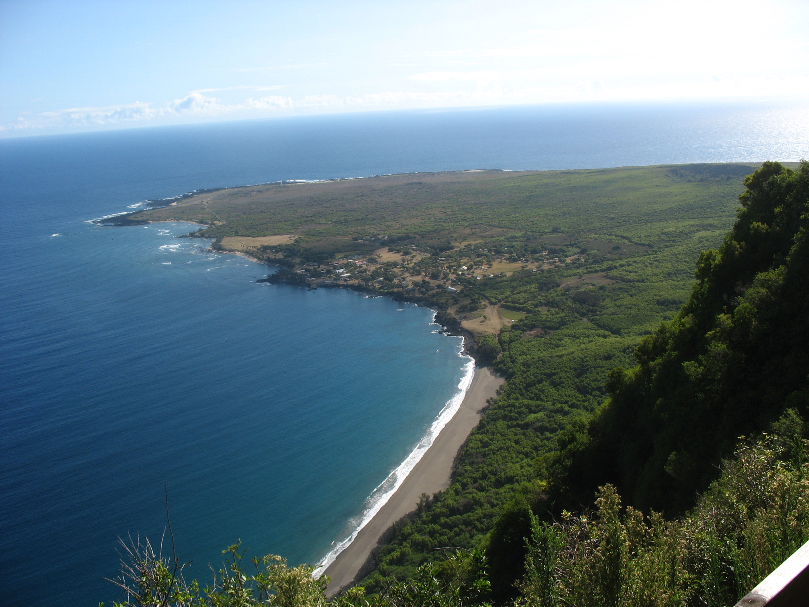
From the Air
Kalaupapa sits at approximately 21.15N, 156.92W on a flat volcanic peninsula projecting from Molokai's north coast. From the air, the peninsula is unmistakable: a green, low-lying shelf at the base of cliffs exceeding 2,000 feet. Kalaupapa Airport (PHLU) has a single runway and scheduled service to Molokai Airport (PHMK) and Honolulu (PHNL). The Kauhako Crater is visible at the center of the peninsula. The trail switchbacks zigzagging down the cliff face can sometimes be spotted from the right angle. Approach from the north for the most dramatic view of the cliffs.