Kalk Bay
The fishing boats come in around mid-morning. They round the harbor wall at Kalk Bay with their catch already sorted, and within minutes the fish are laid out on the quayside -- snoek, yellowtail, whatever the sea offered that day -- while buyers crowd in to negotiate before the restaurants get first pick. It is a scene that has played out here for generations, long before Kalk Bay became one of the Cape Peninsula's most fashionable addresses. The village sits on the eastern shore of the peninsula, facing False Bay, a few kilometers south of Muizenberg and north of Fish Hoek. Its name comes from the Dutch word for lime: the kilns that once burned seashells into building material on this shore gave the bay its identity centuries ago.
The Main Road Corridor
Everything in Kalk Bay happens along a single axis. The Main Road -- the M4 -- runs through the village parallel to the railway tracks and the sea, and nearly every shop, restaurant, and gallery opens directly onto it. The effect is compressed and intimate: you can walk the entire commercial stretch in fifteen minutes, but stopping at every window that catches your eye could take an afternoon. Antique dealers sit next to contemporary jewelers. Vintage clothing stores share walls with craft breweries. The Brass Bell, perched at the water's edge near the station, has been a local institution for decades, its terrace so close to the sea that waves occasionally reach the diners. Cape to Cuba, just up the road, trades on atmosphere and rum cocktails. The architecture along Main Road is an unplanned mix of Victorian, Cape Dutch, and improvised -- fishing-village pragmatism overlaid with bohemian flair.
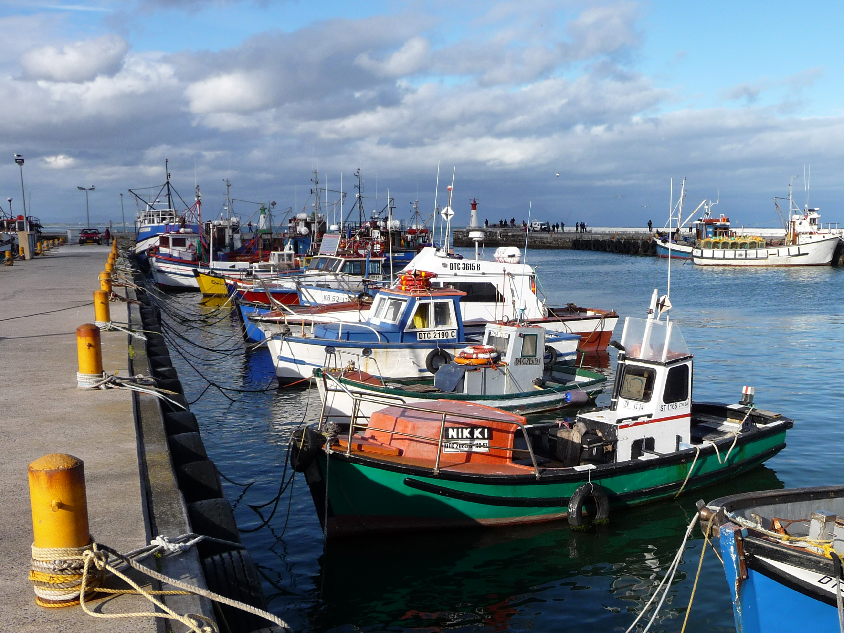
A Working Harbor
What distinguishes Kalk Bay from the Cape's other picturesque villages is that its harbor still functions. The fishing fleet is small but active, and the daily catch creates a rhythm that the boutiques and coffee shops have adapted to rather than replaced. Fresh fish restaurants cluster next to the harbor wall, their menus dictated by whatever came in that morning. Walk up the small, twisting alleys on the mountain side of Main Road and you encounter the older Kalk Bay -- houses built by fishing families over generations, some now converted to apartments or shops, others still occupied by the descendants of the people who built them. The community here has deep roots, and the tension between preservation and gentrification is a constant undercurrent in a village where property values have climbed steeply.
Between Mountain and Sea
Kalk Bay occupies a narrow strip between the Silvermine mountains and False Bay. The topography is dramatic: cliffs rise steeply behind the village, and the sea is never more than a few dozen meters from the main road. The Southern Line railway, running from Cape Town to Simon's Town, passes through the village center, its station one of the most scenic commuter stops in the country. Trains arrive from Muizenberg to the north and Fish Hoek to the south, making Kalk Bay easily accessible without a car. The compactness is part of the appeal. You can cover the entire village on foot, from the harbor at one end to the last antique shop at the other, with detours up the hillside alleys for views across False Bay to the Hottentots Holland Mountains on the far shore.
Gateway to the Peninsula's South
Kalk Bay sits at the midpoint of a coastal journey that draws visitors south along False Bay toward Cape Point. Continue past Fish Hoek and you reach Simon's Town, home to the South African Navy and a bronze statue of Just Nuisance -- a Great Dane famously enlisted as an able seaman in the Royal Navy during World War II. A little further, Boulders Beach shelters one of the few land-based colonies of endangered African penguins, the birds nesting among granite boulders and wandering into residents' gardens. The road eventually reaches Cape Point, where the Cape Peninsula tapers to its dramatic end. But Kalk Bay itself requires no onward destination. The village is the kind of place where you arrive planning to stay an hour and find yourself lingering through lunch, watching the boats come in and the shadows lengthen across the harbor wall.
From the Air
Kalk Bay is located at 34.13°S, 18.45°E on the eastern shore of the Cape Peninsula, facing False Bay. The harbor and village are visible as a small indentation in the coastline between Muizenberg to the north and Fish Hoek to the south. The railway line runs along the shore. Nearest airport: Cape Town International (FACT), approximately 30 km north. Best viewed at 2,000-4,000 ft AGL following the False Bay coastline. The Silvermine mountains rise steeply behind the village.