Kamaehuakanaloa Seamount
Somewhere between 10,000 and 100,000 years from now, a new Hawaiian island will emerge from the Pacific. Its summit already rises more than three thousand meters above the seafloor, making it taller than Mount St. Helens was before the catastrophic 1980 eruption. But you cannot see it. Kamaehuakanaloa Seamount -- the "glowing child of Kanaloa," named for the Hawaiian god of the ocean -- lies entirely beneath the waves, about 30 miles off the southeast coast of the Big Island. It is the youngest volcano in the Hawaiian-Emperor seamount chain, and the only one still in the deep submarine preshield stage of development.
A Volcano Hiding in Plain Sight
Until 1970, scientists assumed Kamaehuakanaloa was a dead seamount, an ancient volcanic remnant dragged to its current position by millions of years of seafloor spreading. Charts labeled it "older volcanic feature." Then a series of earthquakes off Hawaii's coast prompted investigation, and researchers discovered that the seamount was not ancient at all -- it was young, active, and growing. A 1978 expedition found the summit encrusted with both old and fresh lava flows, and fluids erupting from active hydrothermal vents confirmed the volcano was very much alive. Kamaehuakanaloa had begun forming roughly 400,000 years ago, fed by the same hotspot deep in the Earth's mantle that built every island in the Hawaiian chain. Unlike the Ring of Fire volcanoes that line the Pacific's plate boundaries, Hawaiian volcanoes grow in the middle of a tectonic plate, powered by a plume of magma rising from below.
The Summer the Summit Collapsed
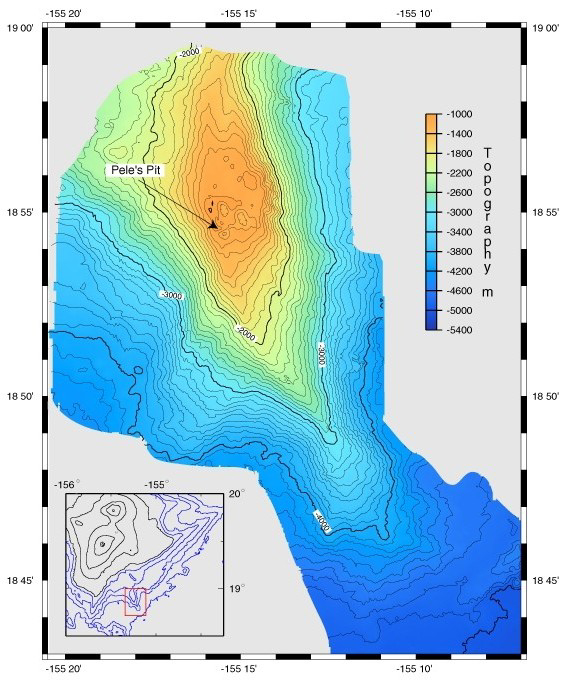
In the summer of 1996, Kamaehuakanaloa announced itself to the scientific world with the most energetic earthquake swarm in recorded Hawaiian history: 4,070 earthquakes shook the seamount. The National Science Foundation scrambled a rapid-response cruise, led by University of Hawaii scientist Frederick Duennebier, to investigate. What they found was dramatic. The southern portion of the summit had collapsed. An area called Pele's Vents -- previously considered stable -- had fallen entirely into itself, creating a massive pit renamed Pele's Pit. Bus-sized blocks of pillow lava perched precariously along the crater rim, and strong currents made submersible diving hazardous. The collapse involved the rapid withdrawal of magma from beneath the summit, reshaping the volcano's profile in a matter of weeks. The swarm also revealed that Kamaehuakanaloa's magma chamber is extremely shallow, sitting just a few kilometers below the summit.
Life at the Vents
Around the hydrothermal vents that dot Kamaehuakanaloa's summit, an unusual ecosystem thrives. The vent fluids run rich in iron but low in sulfide -- conditions that favor iron-oxidizing bacteria over the sulfur-dependent organisms found at most deep-sea vents. Among these specialists is Mariprofundus ferrooxydans, sole member of the class Zetaproteobacteria, which was first studied in detail here. Microbial mats carpet Pele's Pit and surround the vents in dense, rust-colored communities. Larger life is scarcer. Fish species include the Celebes monkfish and members of the cutthroat eel family. Two invertebrate species were endemic to the vents: a bresiliid shrimp named Opaepele loihi and a pogonophoran worm. After the 1996 earthquake swarm, submersible dives could not find either species, and their fate remains unknown.
A Name Restored
From 1955 to 2021, the seamount was called Loihi, the Hawaiian word for "long," describing its elongated shape. In 2021, the Hawaii Board on Geographic Names assigned a more culturally significant name: Kamaehuakanaloa, meaning "glowing child of Kanaloa." Researchers at the Bishop Museum found the name in two Hawaiian mele -- chants -- from the 19th and early 20th centuries. The U.S. Geological Survey adopted the change. The renaming reflects a broader effort to restore native Hawaiian naming traditions to the landscape. Kanaloa is the Hawaiian god of the ocean, and the seamount is, in a very real sense, his offspring: a volcanic child growing slowly on the ocean floor, fed by the same deep-earth forces that created the islands above. Whether anyone alive today will see it break the surface is another question entirely. The Pacific is patient, and so is the hotspot.
From the Air
Kamaehuakanaloa Seamount is located at approximately 18.92°N, 155.27°W, about 30 miles southeast of the Big Island's Ka Lae (South Point). The seamount is entirely underwater and invisible from the surface, but the open ocean above it can be overflown on southeast departures from Hilo International Airport (PHTO). The nearest coastline is the Puna district's volcanic shore. At cruising altitude, the deep blue water above the seamount contrasts with the shallower waters near shore.