Kamakura's Seven Entrances
Look at Kamakura from the air and the logic is immediate. Steep, forested hills close in on three sides like the walls of a bowl, and the Pacific Ocean seals the fourth. Before modern tunnels and paved roads, the only way in or out was through seven narrow passes cut into the surrounding ridgeline -- artificial notches carved through rock and earth, each one steep enough and tight enough that a small garrison could hold off a much larger force. Minamoto no Yoritomo saw this geography in 1180 and chose Kamakura as the seat of Japan's first military government for exactly this reason. The seven passes were not natural features. They were engineered chokepoints, and for 150 years they made the shogun's capital nearly impregnable.
The Fortress That Geography Built
The Azuma Kagami, the official chronicle of the Kamakura shogunate, records that Yoritomo selected Kamakura specifically for its defensive terrain. The chronicle refers to the passes simply as "-zaka" -- slopes -- listing them as Kobukurozaka, Daibutsuzaka, Gokurakuzaka, and others. The term "Seven Entrances" (Nana-guchi) appears later, in Muromachi-period literature around 1450, by which time the passes had already acquired legendary status. Each one was a declared historical landmark, and together they formed a ring of controlled access points that turned a small coastal city into one of the most defensible positions in medieval Japan. Fortification remains -- artificial cliffs and leveled fighting platforms -- are still visible along several of the passes today.
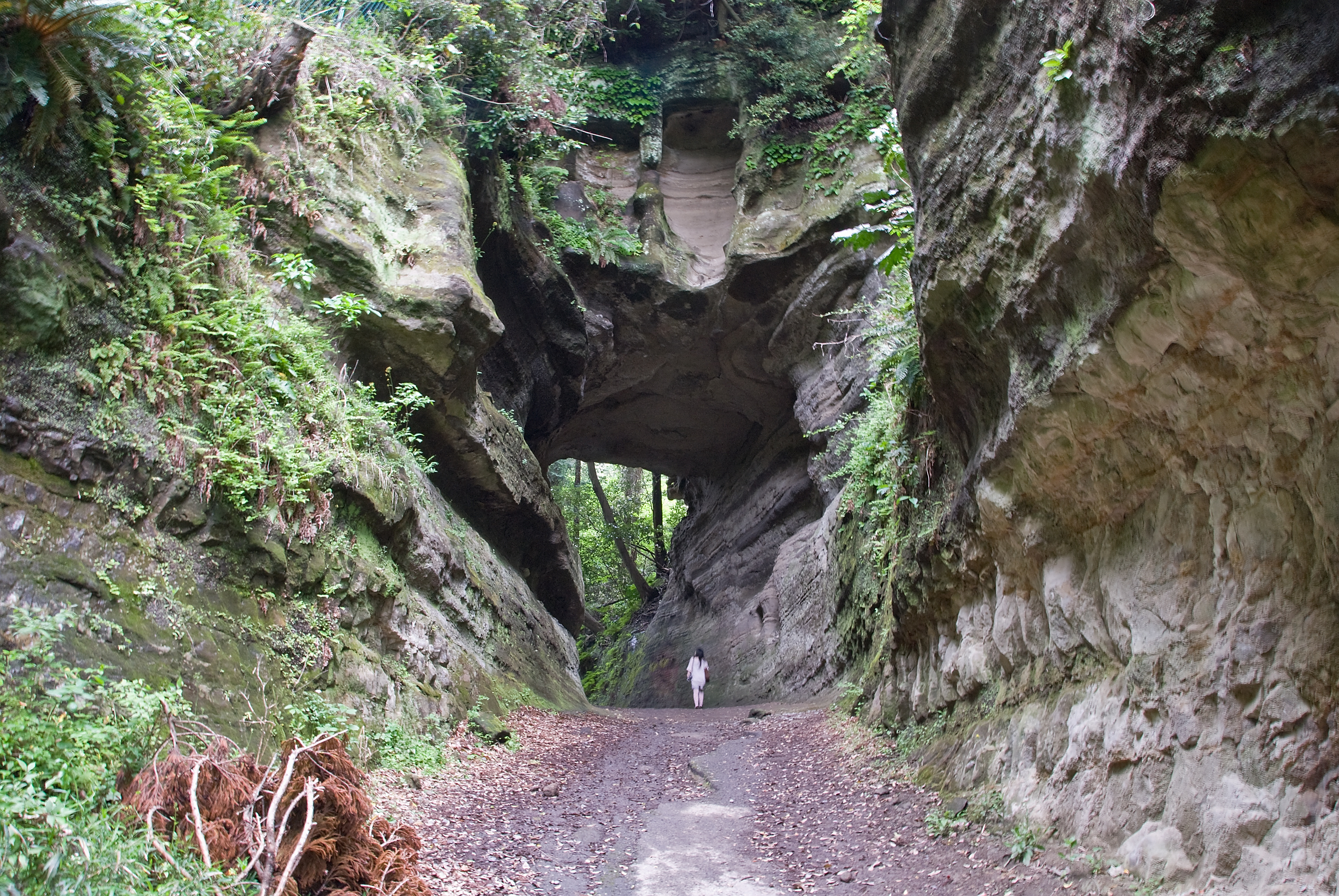
The Steepest Gate: Asaina Pass
In 1240, the Kamakura shogunate ordered improvements to the pass connecting the capital to the port of Mutsuura, a critical hub for salt production and maritime trade with provinces like Awa, Kazusa, and Shimosa, as well as Korea and China. Construction began the following April, and Hojo Yasutoki, the shikken (regent) himself, personally directed the work -- carrying stones and dirt on horseback to speed the project. The resulting Asaina Pass became the steepest of the seven entrances, a lung-burning climb that rewarded defenders with commanding views of any approaching force. On both sides, the remains of fortifications are still visible: artificial cliff faces carved to deny footholds, and flat terraces where soldiers could mass for counterattack. Near the Kamakura side, a stone stele stands beside Saburo Falls, commemorating the pass's designation as a historical landmark in 1969.
Where Armies Clashed
The passes were not merely theoretical defenses. They were tested in battle. The most dramatic test came in 1333, when Nitta Yoshisada led a massive assault on Kamakura to overthrow the Hojo regency. His forces attacked along multiple passes simultaneously. At the Gokuraku Pass -- a road opened by the priest Ninsho, founder of Gokuraku-ji temple, who had flattened a hillside to create it -- generals Odate Muneuji and Eda Yukiyoshi pushed their troops forward and clashed with Kamakura's defenders under Osaragi Sadanao. At the Kewaizaka Pass, fighting raged across a slope whose very name carries the violence of its history: one theory holds that the name derives from an incident in which makeup was applied to the severed head of a captured Taira clan shogun to make identification easier. Nitta's invasion ultimately succeeded, but only after his forces found a way around the passes entirely, wading through the shallows at low tide along the coast.
Paths Through Time
Several of the seven passes survive in recognizable form. The Daibutsu Pass, running from above the modern Daibutsu Tunnel through Kajiwara and Yamazaki to link Kamakura with Fujisawa, was repaired repeatedly from the Edo period through the Meiji era and is now a designated Historic Site. The Kobukurozaka Pass, first recorded in the Azuma Kagami in 1235, follows an old road built by the Hojo regents from Tsurugaoka Hachimangu toward Yamanouchi and Kencho-ji. The Kamegayatsu Pass, whose name appears in the chronicle as early as 1180, connected the area near modern Kamakura Station to the temples of Kita-Kamakura. Some have been paved over. Others remain rough footpaths through bamboo and cedar groves. The Shakado Pass, though not counted among the seven because it connected two areas within Kamakura rather than leading outside the city, is now closed entirely due to rockfall danger -- a reminder that the same geological forces that made these passes defensible also make them unstable.
From the Air
Located at 35.319N, 139.550E in Kamakura, approximately 50 km southwest of central Tokyo. From the air, the distinctive geography is clearly visible: the horseshoe of forested hills surrounding the city on three sides with the Pacific coastline forming the southern boundary. The pass routes can be traced as gaps or low points along the ridgeline, particularly the Daibutsu Pass on the west side near the Great Buddha temple. Nearest airports: Tokyo Haneda (RJTT) approximately 30nm northeast, Atsugi Naval Air Facility (RJTA) approximately 15nm northwest. Sagami Bay provides visual reference to the south and west, while the Miura Peninsula extends southward. The surrounding terrain rises steeply to 100-150 meters, making the pass locations identifiable as the only low corridors through the hills.